Updated 8th September, 7-11th November 2009; 26th June, 17th July, 31st October 2010; 6th January, 18th May, 16th, 30th October, 5th November, 4th December 2011; 18th February, 27th September, 29th November, 27th December 2012; 30th April, 23rd June 2013; 23rd, 24th May 2014; 23rd May, 4th October 2015; 5th May 2016; 23rd May, 4th October, 22nd November 2017; 20th February, 8th, 12th March, 10th, 14th May, 1st July, 24th September 2018; 29th January, 16th, 27th May, 24th July, 18th-20th September 2019; 8th January, 23rd August 2020; 31st October 2020; 8th April, 5th, 9th November 2021; 20th May, 20th September, 12th November 2022; 9th February, 23rd March, 19th May 2023; 2nd May, 7th June 2024
The length of Llanío was 7268m when it was linked into the Four Valleys System (Cueva de Riaño) on 30th July 2019. All caves which are part of the Four Valleys System are listed at the start of the Cueva Hoyuca description. The system was linked to Fridge Door Cave (1800) on April 5th, 2023 through a dig at the far western end - and again, from Fridge Door Cave (April 2025), linking to a lead at the base of the Cross Roads Shaft. Passages to the west, e.g. High Pulse and the complicated area to the west of Playing Card House Pushover will require more examination and work as it also comes close. This video gives an indication of the distances and potential although the dig in Llanío is at the start of High Pulse, not the end, and the distances to Fridge Door Cave are much reduced - see this video from August 2022.
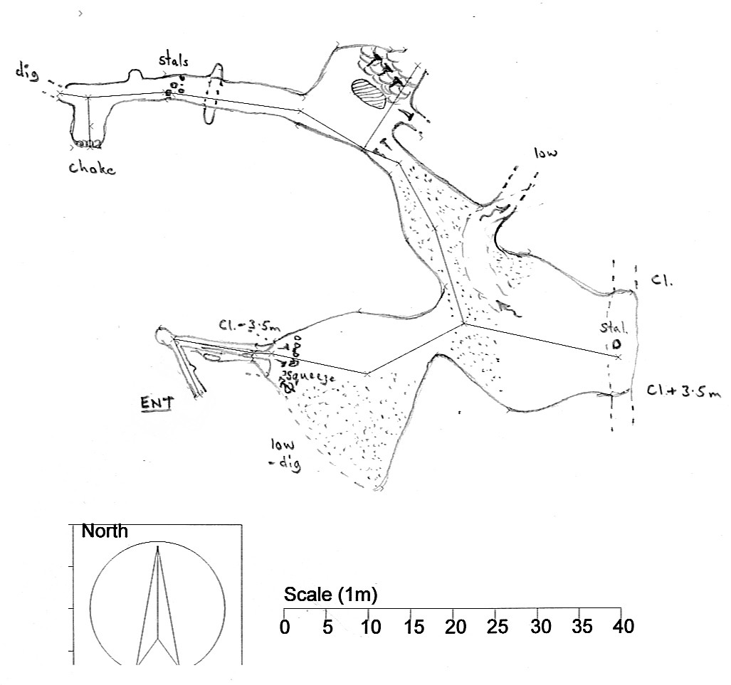
SubPhone Entrance (site 4536) This 7m deep, excavated hole is best approached by climbing down below the road to the right of a road drain. The entrance (which may be invisible under brambles and nettles) has a metal cover and opens onto a 3.5m climb down in a roomy, plastic road drain tube. A narrow drop at the base enters the cave at station 17-03.106. Stooping passage and a climb down enters Under Road Chamber. SubPhone Entrance allows much quicker and easier access to the eastern passages, ie Mulu Manners and beyond. (See site 4536 for the excavation of this entrance.)
Original entrance and the eastern passages
Note: April 2018 - There are now a number of bee hives in the entrance field and the bees were showing "some interest" in cavers walking to the entrance. It may be that the hives will be moved to a more productive area for the summer months.
The hives were present in greater numbers at Easter 2019. On 21st June 2019, one caver walking back up the field suffered 6 bee stings. Bee activity continues through autumn 2022.
March 2023 A large flat area of gravel with foundations / footings has been laid at the top of the entrance field. This is for a honey processing plant. These works (Picture here from Andy Quin.) will have an effect on underground drainage and will possibly curtail the scientific work, both current and planned (see below).
batch 09-01 The normally draughting entrance is a short crawl off the side at the back of a dressed-stone-walled sheep enclosure. This leads to a tight bend to the right and enlarging passage to a small traverse.* A 3.5m climb down at the end leads to a squeeze, crawl then stoop to a wide passage beyond. A seasonal stream enters from a walking-size inlet on the right and ends at a 1.5m high column on small gours in High Hopes. A passage passes over the top. The southern side has been scaled into a short passage, No High Hopes, to a choked chamber (batch 09-02) and the northern side is blind.
On the northeast side of High Hopes, a low stoop and crawl through a loose hole enters a walking-size phreatic tube to an excavated U-tube with a longer uphill crawl on the other side (batch 09-03) that breaks out into the Left Ladders Series (batches 09-05 and 09-06). Walking-size phreatic passage heads south to a junction.
To the south, large passage with some nice formations and pits eventually finishes in tall phreatic domes. (More description needed). At Easter 2013, the small continuing passage to the northeast off station 09-06.1a (at the southern extremity) was examined. It needs capping/snapping for at least 5 meters and there is very little draught. Forty metres to the NNW northwest, a small passage which heads northwest was dug out in dry sand for 2m but it needs a lot more digging. There was very little draught.
To the east, mixed going leads to a traverse over an 11m pitch and further stoops and crawls to a small chamber where, to the right a pitch is reached and straight on, a sandy dig (Blood, Sweat & Tears) has been pushed to a stooping passage and a rift, initially blocked with stal but pushed through at Easter 2010 for 20m or so to a squeeze and a dig. (batch 10-04). This was partly pushed in February 2012:
The floor is sandy and easy to dig. A hammer and chisel is useful for thin calcite in the floor. It is possible to see about 2 meters into passage (20cm high and 1m wide) with a slight draught towards the excavator. It is a flat out crawl with good potential. More digging occurred in the summer, 2012, and it is now possible to see about 6m along passage 20cm high. There was a good draught.
The 11m, Blood, Sweat & Tears pitch at the end of a small passage, was descended over the Matienzo November fiesta weekend and a major segment of passage explored. Batch 09-09-14 has a length of 237m. The current ends include avens and a low duck at the north west, upstream end. The weather was extremely wet during the first exploration, so neither upstream or downstream ends could be followed. The downstream end is close to the upstream as the passage turns back on itself. Downstream was inspected during a dry spell in the summer 2010. A 20cm diameter hole has a solid rock floor. Stones dropped into water beyond but it was impossible to see if the passage is large or small and whether it is worthwhile trying to enlarge the route.
At Easter 2016, a route was pushed through a crawl to the northeast off station 3234-09-14.blood-and-t-pitch4.0. The route heads down under Bird Wing Chamber as follows:
After the crawl a p1 and p6 requiring a 15m rope and 1 hanger, also using a natural belay;
A rising and falling passage to a p6 with a narrow top (underneath the p8 from Bird Wing Chamber). 10m rope and 3 hangers + 1 deviation;
A short crawl to the 3rd pitch, a p6 that requires a 9m rope and 3 hangers.
The tops of the first two pitches could be enlarged and the pitches were wet at Easter 2016.
The final pitch drops into Mitre Passage. This heads ESE and is 2m wide and 4m high, surveyed as part of batch 16-01, 183m. Mitre Passage ends in a chamber with a mud climb to a possible continuation. There are glimpes of an accessible higher level passage in a number of places. There are also side passages to be checked and a drop at the western end of Mitre Passage. The 2017, major extensions from Mitre Passage (batch 3234-17-03) including the route to the second, SubPhone Entrance and Mulu Manners are described next.
* Two squeezes at the entrance were enlarged in October 2019 and a draughting passage between them was dug to where it became too tight.
Over the drop at the end of the traverse, an eyehole on the left drops 4m in a rift which was also connected back to the main route through an excavated crawl. (September 2021).
Way on past The Shark Possible ways on towards the southwest on the ledge.
Continue flat out under the bedding (stn 146) towards southeast, and up between boulders. From there (stn 149) there are 4 ways on.
The impressive Mulu Manners, an 8m wide and about 6m high passage, continues for about 170m towards the southeast. Towards the south there is a way around (stn 148) the fallen roof back into Mulu Manners. Further towards the south leads to a grotto (stn 176) and a way under bedding (stn 190) which has not been pushed.
Just to the northwest (stn 179) there is a draughting crawl that, in the beginning, is very well decorated with stal. In places it is flat out crawling. At the current end (stn 189) rock flakes are moved to the sides to make access easier. At the end of January 2018, the flat-out crawl was pushed for 15m to a point where it is only 20x60cm wide, but there is good draught. That point was measured to be 8m after stn 189. The passage crosses over the north end of Ali Chamber.
Mulu Manners About 20m into Mulu Manners (stn 151) there is a sandy crawl/dig to the south. About 100m down Mulu Manners, an 8m handline on natural is needed down a slope. Just past the slope and up, the passage splits for about 30 meters (stn 154-155). The passage towards the north has a beautiful anastomoses roof. At the end of Mulu Manners the passage goes up and splits at Mulu Junction.
North and south off Mulu Junction Just north of Mulu Junction, under a gypsum-coated roof, there is a loose slope down which was explored in the summer 2017, and is the route to the South Passage (see below). Crawling further E over rubble leads to two chambers. The southern chamber has a c4? aven in the southern end that needs bolts. Just to the right of the c4 aven, a climb up through a slot leads to the area S of Mulu Junction.
To the south, and on the west wall in a 10m Ø chamber, a 2m climb up enters a 2x3m walking size passage. About 4m in it is possible to make a natural belay with a rope under and around a block. The walking size passage ends at a dripping aven, about 5m high. It may be possible to find a way up, but it requires bolts. The passage continues in a crawl, and opens up again into a chamber with nice straws in the roof. At the end of the chamber there is a dig, about 60cm wide, widening out. The height is about 20 cm but the floor of sand/small rocks is easy to dig. The strongly draughting route continues low for about 3m to where you cannot see further. The end is heading for site 4188, Shrewd Find at a similar altitude and the passage ends are probably no more than 30m apart. (Surveyed as batch 18-01c, 55.0m.)
Back in the 10m Ø chamber, to the north it is possible to climb down between boulders but there is no way on. To the east, there is first a passage heading south to a p25 (stn 163), which could bring the cave down to the lower Riaño Cave level. In January/February 2018, 3 bolts were placed before the drill battery failed. A later trip found the drop impassable due to the amount of water cascading down. (This is likely to be due to water sinking in the wet weather in the valley directly above.) In April 2018, the pitch was dropped and chokes on a sandy floor. A window on the SE is more roomy. An unexplored traverse can lead into a rift on the NW wall.
Finally, there is a passage heading east into a rift where water runs down. This may continue up where the water comes from.
From Mulu Junction to South Passage Up to the left at Mulu Junction, a hole in the floor is the top of a loose scree slope - a 6m slide down with a 12m handline replaced January 2018. (Batch 17-04). A walking size sandy-floored passage leads off. The route meanders with occasional large boulders and slopes to negotiate. Down to the left there is a 15m pitch which has been dropped in a phreatic tube to a muddy floor and no way on. A slope up enters Chamber of Good Manners. There are crawls in the north end and a rift up in the south end becomes too tight. This crawl goes towards the north. However it seems like the "aven" in the southern end can be bridged into with a couple of bolts as protection. A hole in the east wall is the way on and where batch 3234-17-05 (600m) starts - ending to the north at the Ski Slope and, to the south, South Passage.
A roped c2 is the entry to the draughting tube on the east side. A batman rope up loose gravel and down on the other side leads to easy and big horisontal passage with no need for SRT to progress the absolutely dry passages all the way to South Passage. Above the Batman down slope, a roof tube (Ø 1m) has been climbed for 6m (2 bolts) to a horizontal level that went for 3m until filled with diggable size rock/flakes. It was possible to see 3m further, but the space was only 10 cm high. In the first large chamber after Batman, the climb down leads to a flat sandy/rock floor under bedding with no way on. The passage/rift heading N was investigated in April 2019 and the ascending rift closed in after about 10m. There are very few formations. On the way towards The Ski Slope there are canyons with sand and boulder strewn floor and a big chamber with possible ways on to the north and down, eg batch 18-07 slopes down from station 17-05.27 and leads to 28m of horizontal passage. The Ski Slope leads to some passages that all seem to end in the same boulder choke, where it is wet. The top of this boulder choke is at a similar altitude to the passage choke in the high level passage, Dingle's Delight in Cueva de Riaño, and 33m further to the NNE. This choke at the top of the Monster Ramp may be pushed over the top via the draughting aven at stn 17-05.47 (about an 8m climb). There is also a passage on a cracked mud floor that gets too small. Batch 18-08 description to go here.
At the start of South Passage you have to balance on a ridge of break down. At stn 17-05.64 exploration was left in the summer 2017 with more ways on.
Near the end of South Passage, near Don't Stop Now, an 8-bolt climb up from station
3234-18-02.21 was surveyed as batch 22-01, extending the cave by 31m, height 20m.
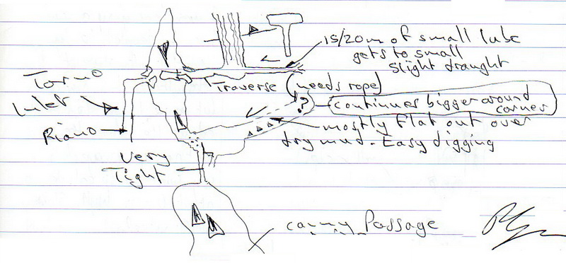
Canny Passage is entered down a rope on the east side of South Passage. A c-2 enters walking-sized passage past a roof fall to a hole in the wall on the right. A 4m roped climb down is soon met and a large chamber that funnels in from 2 sides. At the top, on the north side, is a possible mud dig. A hole in the centre enters a very tight, draughting route down to the top of the Torno Inlet in Cueva de Riaño (see video). A white marker has been left at the top of the inlet which should be visible from below. The Canny Passage was surveyed as batch 3234-19-02. Length 194m.
Canny Passage was extended (but not surveyed) in April 2022. Both small extensions occurred beyond the very tight squeeze. The first, opposite the route to the Tippex marker above the Riaño stream, was entered after some rocks clearance. A traverse leads to small tube which becomes too tight after 15 / 20m. The second prospect is below the tight section where a dig needs more work to reach a corner where it continues much bigger. A sketch of these extensions from the logbook and is included on the "After April 2022" survey.
B Chamber and beyond (see survey. Description edited from logbook entries by Torben Redder.)
Exploration down South Passage continued in January / February 2018.
The left hand route continues low (flat out) for about 10m, then opens up into a 15m high rift/chamber (B Chamber).
There are multiple small ways on from the chamber and it is quite complex.
Climbing a C+2 on the northwest side leads to a way in behind the wall, where it is possible to get up left to a point looking down into B Chamber. A rift heads south and splits. Towards the SE it gets too narrow.
Towards the NW (New Hope) there is, at stn 18-02.10 a passage with drop down into the top of B Chamber (voice and visual connection). Further up there is an aven from where water continues down the p20? below. There are loose boulders around the rim of the shaft. The leads in the southeast of New Hope were investigated in the summer 2020:
A1 - A squeeze into tube is restricted by stal that need big hammer or snapper. There is a draught, but we were there on a day with outside temperature 36 deg C.
B1 - A climb up (c4) was done with two bolts, but the passage ended after 3 metres.
C1 - A squeeze in top of a crack leads to a p4. At the top of P4 there was no draught from below, but only from between the boulders above. At the bottom of p4 there may be ways on between boulders. "We did not push it."
The"p20?" turned out to be a p24 when dropped and passages below were explored and surveyed over Easter 2019. (Consolidated as batch 19-02.) An overnight camp was established just before B Chamber on a sandy area. The pitch was rigged with a 10m rope for a traverse line from a natural to a Y-hang; from the Y-hang, a 24m rope. There is water spray in the shaft which responds very quickly to the weather. The rim of the shaft has loose boulders.
At the bottom of the p24, a tube goes north and slopes down to a 2m climb down to a stream, the Getting There Series. Going south at the bottom of p24, and then turning right and crawling down in a sloping passage leads to a stream.
The stream can be
followed down two climbs to a hands-and-knees crawl. Just before the end of the main passage to the right, a low, wet and muddy crawl winds towards the north for about 10-15m where there is nowhere to turn around. At the end, the height is about 20cm with a rift in the roof. After about 2m, it seems to get higher again. There is a good draught and water drips can be heard with an echo from the other side. This was surveyed as batch 19-03 in the summer 2019.
The cave was linked to Cueva de Riaño from the Getting There series on 30th July 2019. An excavated squeeze (the connection) on the north of the passage enters the base of an aven (in Riaño) and a further squeeze out into a sandy crawl heading northwest to a climb down into Torno Inlet. Turning right at the crawl also reaches the stream.
At the bottom of p24, heading up the rift, a climb up between boulders (past a mouse skeleton) leads to a well decorated chamber, Mouse Chamber. Mouse Chamber can also be reached directly from the p24.
Mouse Chamber, northeast end:
Climb up slope over boulder into a well decorated passage, Column Corridor. Follow Column Corridor to a 2x2m window overlooking the higher level above the southwest end of Mouse Chamber. Column Corridor was first entered from there by climbing the vertical c4 (time wasted). Further along Column Corridor, a nice, walking size meander heads south to First Boulder Chamber and Second Boulder Chamber. In Second Boulder Chamber it is possible to climb down in the floor.
Mouse Chamber, southeast end:
1) A crawl heading east leads to a p5 with an unpleasant, tight pitch head that drops to a 2x2m chamber with no way on.
2) A walking size passage south leads to a crawl along a solid wall with boulders to the left. At the end there is a stal constriction, that will dig with a large hammer/chisel/crowbar.
Mouse Chamber, southwest end:
Climb up 4m between boulders to reach the top of the choke. From there the window into Column Corridor is seen.
Don’t Stop Now. This is back in South Passage where a ramp up behind large boulders leads to a steep sandy ramp down into a space under bedding. There seems to be two ways on (not surveyed yet): one with a p8 and another possible lead straight ahead, from where it is possible to see into the p8 through a rift.
Napoleon Passage. (Surveyed as batch 18-09; length 170m) A c+4 leads to horizontal passage. A rope has been left as a hand line. About 10m into the passage, beyond the climb, there are strongly draughting - but too small - holes in the south wall. The 4m high canyon can be followed in the top, changing to walking size and then crawling before it pops out into a 3m wide passage, Battleship Down! Towards the E it chokes; a passage rising to the south then west also chokes. To the west is a 12m pitch which has no draught but may continue in a rift down. Above the p12, a 4-bolt traverseon the N wall leads to a 3m diameter chamber with a lot of helictites but no way on. The roof is choked with boulders.
B Drop. A well decorated, 4m high and 2-3m wide route sets off from the summer end of South Passage and leads to a pitch with a p8. The bottom of p8 is B Chamber, so the p8 was not dropped. (Surveyed as batch 18-02, 168m).
Crystal Mine. As above, climbing up the c2 in the NW corner of the wall in B Chamber and spiraling up left behind the wall leads to the view point above B Chamber (stn 1.5). This is followed by a climb (protected by 1 bolt and stal) up in the N corner. From there a walking size meandering passage is heads west for about 100m. The passage is very nicely decorated with stal and helictites. At the end the passage gets too small.
In August 2018, 3 dig queries around B Chamber were excavated and found to join to known passage.
Batch 3234-17-06 A short body sized tube leaves the main passage east, roughly 25m south of the junction at station 17-05.27. A large fallen white flake of calcite marks the entrance to the side passage. At the bottom of the tube, a T-junction is reached and the passage is stooping height.
To the right the passage closes down almost immediately with no prospects. To the left the passage enters a small low circular chamber up a steep ramp. From here two routes converge on another chamber surrounded by fallen boulders. The main route continues round the circular chamber and down a steep slope. A second route is through a tight crawl, partly blocked by a boulder.
From this second chamber, the roof height enlarges significantly. A low route east under a huge fallen boulder could be seen but was not pushed or surveyed. Straight on up a slope in a gap between fallen boulders leads to a junction (17-06.9 - marked by a small cairn).
From this junction heading north leads up a steep slope and a 1m high step into the big chamber at 17-05.29. Heading east is in a short wide passage with many fallen rock flakes towards a rift heading roughly north/south (stn 13).
In a hole in the floor below stn 13, a big chamber can be seen below. The chamber was briefly entered beyond stn 14 in the summer but not pushed or surveyed due to time constraints. The documentation of WWNTF happened in February 2018.
We Were Not The First (WWNTF) The series can be entered from the south via the east/west passage. Another route is from stn17-06.14: the p2 drop leads to a shelf, from where there is a 4m drop into the chamber below. Getting across the p2 drop into a tube leads to a junction where there are 3 ways on, one down towards the north (a dig in sand/rock, 40x10 cm), one up towards the north (draughting, solid rock 20 x 80 cm, may get wider around corner) and the last down towards the south, from where the WWNTF Chamber is entered.
In the southern end of WWNTF Chamber, there are 2 ways on:
1) A low sandy crawl that draughts but get too low. At that point the passage has a flat roof and sandy floor with sand slopes up to the sides - easy digging. This was dug for 6 hours on 6th April 2022. At a cross-rift it was possible to get up into the roof but snappers are required.
2) A climb up towards the east leads to a ledge, from where a rift is entered and also “continues low under boulder” is reached. At the ledge there is also a c2 up back in the chamber above WWNTF Chamber. The rift heads south and ends at a 20 cm wide rift that draughts.
Batch 3234-17-07 From the main passage at 17-05.22, a low passage leads off roughly east and shortly enters a chamber with many fallen rock flakes. To the south, a low crawl under a boulder leads into a stooping-height chamber at stn 3 (cairn) and eventually into a walking height passage. The passage ends in a huge boulder choke underneath the main passage between stations 17-05.50 & 51. A very low crawl was evident heading west from the stooping height chamber but not investigated fully.
Heading instead along the long-axis of the chamber at stn 3, a low crawl in the roof drops down into another small chamber, where a voice connection was heard from a hole in boulders below the main passage junction at 17-05. 27. A small passage from this chamber emerges into the main passage just south of the station 27 junction.
South-ish Passage (batch 3234-17-08) in entered down between boulders at the start of South Passage.
Back at the base of The Aven, the passage slopes down over mud to a pit in the floor and a level area just before station 16 on a large rock. This is another hub and routes and passages are more numerous from here on.
(Batches 09-1311 & 09-131) The pit is a 3m ladder climb through a mud-lined slot to the head of an 15m free-hanging drop in a large rift. This is probably best dropped using SRT as there is a possible passage to swing or traverse into 5 or 6 metres up from the bottom. The drop ends on a ledge with a climb over a lip to a drop of at least 15m which is undescended. (The probable base of this would be at the same altitude as Terminal Decline.) A short climb down from the ledge ends below a possible climb up into the visible passage to the west.
During summer 2010, this was re-explored and extended and described as follows:
"Muddy, awkward top opens out with an easy descent to a bridge between drops. A short climb down then up enters a short section of passage which chokes." (Included in batch 10-09). "From the top of the bridge, pitch descends to an awkward mud hole (easy dig) to a further drop and a short horizontal section to a further drop of c5m. Needs bolts before and after mud hole." A section sketch of the pitches (from the 2010 summer logbook) can be seen here.
(Batch 09-091) The large passage to the north of the pit contains 3 rifts which can be skirted around or climbed into. At the base of the middle one, a dig to the east has gone 20+m to another dig and a passage that becomes too small, while the further rift links to known passage to the west. Beyond the rifts, the passage swings to the left (with a possible climb up on the left wall) and rises on sand to an apparent dead end. However, a narrow climb up on the left and squeeze through closes the Jovens' Loop - larger people enter the rest of the loop at station 16.
Where the passage swings to the left, a climb up in a boulder-floored rift enters the Lazo de Ancianos, surveyed as batch 2889_11_01. A small passage passes through a couple of squeezes and a short crawl in a tube before reaching a small T-junction. To the right (northwest) the passage closes down. To the left, a 5m flat out crawl has been dug and pushed by one person to a short section of (unsurveyed) walking passage that closes down at a small hole as it apparently approaches the Joven's Loop.
The sandy dig at the "apparent dead end" was excavated at Easter 2011 and immediately connected with station 0 (1/8/09) in Joven's Loop.
(Batch 09-092, batch 09-093) Turning west at station 16 leads to smaller passage. The Jovens Loop route turns right at a cracked arch feature and carries on with a climb along the right wall of a rift. Straight ahead the passage becomes too low on rubble but, to the right, a low crawl on rubble under a loose roof eventually emerges in a sandy passage which meets a cross rift with solution pockets and an immediate slope up and tight squeeze through to complete the round trip.
Stepping over and around the rift after the cracked arch leads to a smaller route to Snap, Crackle and Pop (Batch 09-094), an excavated section where it is now possible to slide up the side of a large boulder into low passage, Playing Card House Pushover. The next 65m (batches 09-108 & 09-107) is stooping or hands-and-knees crawling over roof collapse, passing a hole - the entry to Yorkshire Passage - down to the left. The route enlarges at a sloping pitch head with a fine view across to the continuation of the passage swinging to the right. The 9m pitch slopes down over loose rubble with a 4.5m vertical drop to finish. (Batches 09-1110 & 09-119) The base chokes in both directions.
In the summer 2010, the 6m climb at the western end
was tackled but the passage at the top is now entered by a roped traverse along the southern wall requiring a harness and cowstails. (When inspected in July 2022, an adequate line was found in place with rusty bolts, solid hangers and very rusty maillons (but seemed solid). A hand jammer could be useful for the final traverse leg up into the continuing passage. A walking passage at the top leads past formations to a 15m high aven with a fine white calcite wall with a possible passage at the top. There may be possible holes down to the right. The Playing Card House Pushover Extensions continue through walking passage to a crawl and further walking passage to a lined traverse over deep drops into a more complex area. The various leads were tackled in this northwestern end over one trip in the summer 2011, including a bolt traverse to a possible "black hole". The survey has the results of these climbs and pitch explorations.
The sinuous route through Yorkshire Passage (batch 09-106) soon ends at a small chamber that slopes down over loose rubble to a 3m vertical drop, passing precariously close to a metre-high stalagmite. To the west, (batch 09-101) walking passage closes up after 20m at an arch filled with rubble that may be a digging prospect. To the east, through a 1m diameter hole with formations on the left, an 8m pitch down the wall of a rift lands on deep sand that slopes steeply down to the other side of the rift with no way on. (Batch 09-121)
Being linked to Cueva de Riaño, and close to Fridge Door Cave, Cueva de Entrambasaguas and Cueva Torno, this is a cave with excellent potential in most directions!
Biological sampling was untaken as part of a research project at Easter 2014.
Over Easter 2018, the Matienzo Karst Entomology Project (led by Tom Thompson) followed up a previous study by collecting bugs, spot sampling and setting pitfall traps in a number of sites under a Cantabria-wide permit. The Entomology Project carried out some work in this cave. Traps were retrieved and spot sampling was carried out over Easter 2019. Photos were also taken.
Water sampling around High Hopes was undertaken to check nitrate levels as a precursor to possible future study. This was followed up in January 2019 when a Lancaster University master's degree student, Scott Ambler, accompanied by Dr Peter Wynn and Andy Quin collected samples for a study of nitrogen levels in water, mud and stal. The sampling points were in High Hopes, Whoopee Hall, the passage beyond that heads back to the surface and The Hub, where a sample of the mud layer on the calcite was taken. (Photos; video) Further samples were taken around Easter 2019 and in the summer. Some results and conclusions are mentioned in "Passages north of Whoopee Hall" - The Hub section, above.
The science paper was published by Peter Wynn et al in Chemical Geology (Elsevier) in April 2021, based on water and stal collected and analysed from Cueva-Cubío del Llanío. Titled "Contemporary systematics of vadose zone nitrate capture by
speleothem carbonate", the paper concludes that nitrate trapped in stal forms a good historical and on-going record of levels of nitrate above and below ground. The potential for measuring changing nitrate pollution in karst areas is obvious. A link to the paper should be available until May 22nd 2021.
A new science project, with a view to producing a "Speleothem Phosphate Palaeothermometer" started in February 2023. This project intends to provide a breakthrough in the field of temperature reconstruction by developing a new palaeothermometer using phosphate-oxygen isotopes contained within speleothems. The NERC-funded project will uses Llanío as the collection centre for taking water samples to measure phosphate levels along with temperature and CO2 data. The research team includes Peter Wynn and Ben Surridge from the Lancaster Environment Centre of Lancaster University and Andi Smith from the British Geological Survey. See an introductory article
On 2 occasions in April 2024, Peter and Andi with Andy Quin retrieved and redeployed data loggers, checked drip water chemistry and reinstalled two calcite collecting plates and several drip water collectors. At that time, "the entrance was a bit brambly and also contained the smelly rotting remains of several small animals and a large bird, possibly the work of a fox".
This study may be curtailed by the building works taking place at the top of the entrance field (see March 2023, "Original entrance and eastern Passages" note, above.)
Miscellaneous
• John and Gordon from the MCP, while searching in the fields west of the old entrance in October 2019, were shown a number of (known) caves by the farmer. As it came on to rain, he drove them back to their vehicle - "Great guy!".
• In April 2024, Jim Davis reported
an interesting 8cm limestone band all eroded in 3D - Incipient cave formation? Dave Barrett documented "Monster Ramp area had a big draught coming down from above, both in the choked passage and from the calcite ramp, on a very windy day outside".
Survey batches
Abbreviations:
JCa: James Carlisle JCl: John Clarke HL: Harry Long JC: Juan Corrin AN: Alasdair Neill PG: Paul Gelling PP: Phil Papard
SG: Simon Gelling PPa: Phil Parker TR: Torben Redder PFN: Peter Fast Nielson TW: Terry Whitaker LK: Louise Korsgaard MM: Marites Magpantay TCl: Tom Clayton PE: Peter Eagan JO: Jude Onions SR: Sue Ryall DM: Dave Milner BB: Bjarne Buchardt SP: Stig Pallesen TH: Tom Howard PON: Pete O'Neill RB: Richard Bullock ND: Nigel Dibben PC: Peter Clewes DD: Dave Dillon CSm: Carmen Smith
SU: Santi Urrutia DB: Dave Bell
C&C: Compass & clino DX : DistoX
| Batch | name | date |
surveyors & assitants | method |
| 09-01 | entrance passages | 16/04/2009 |
JC, HL | C&C |
| 09-02 | No High Hopes | 01/08/2009 |
JCl, JC, HL | C&C |
| 09-03 | east to dig | 01/08/2009 |
JCl, JC, HL | C&C |
| 09-05 | east beyond dig | 02/08/2009 |
AN, PP | C&C |
| 09-06 | east beyond dig | 02/08/2009 |
AN, PP | DX |
| 09-07 | W from stn 6 | 02/08/2009 |
JCl, HL | C&C |
| 09-08 | Pulse Racer | 3-4/8/2009 |
JCl, PPa | C&C |
| 09-09 | N beyond The Hub | 07/08/2009 |
JCl, JC | DX |
| 09-10 | Beyond Snap, C&P | 11/08/2009 |
JCl, JC | DX |
| 09-11 | Beyond Snap, C&P W p | 13/08/2009 |
JCl, JC | DX |
| 09-12 | Beyond Snap, C&P S p | 13/08/2009 |
JCl, JC | DX |
13/08/2009 |
||||
| 09-14 | down p11 in LL Series | 09/11/2009 | PP | DX |
| 10-05 | consolidated batches | 29/3-1/4/2010 | TR, PFN, TW, JCa, LK | DX |
| 10-04 | extension to E to dig | 02/04/2010 | JCa, TCl | C&C |
| 10-06 | sand choke below 32m aven | 03/08/2010 | JCl, PPa | C&C |
| 10-07 | below B,S&T pitch | 09/08/2010 | PP, TR | DX |
| 10-08 | PCHP extensions | 11/08/2010 | JCl, JC | C&C |
| 10-09 | p15 beyond 32m aven | 11/08/2010 | PE, AN, TR | DX |
| 10-10 | PCHP extensions | 13/08/2010 | JO, SR | C&C |
| 10-11 | PCHP extensions | 13/08/2010 | JO, SR | C&C |
| 10-12 | PCHP extensions | 16/08/2010 | AN, PE | C&C |
| 11-01 | Lazo de Ancianos | 26/04/2011 | DM, PPa | C&C |
| (11-02) | incorporated in 11-04 |
|||
| (11-03) | incorporated in 11-04 | |||
| 11-04 | Aven Extensions | 14-17/10/2011 | TR, PFN | DX |
| 12-01 | Eels Shaft and beyond | 2,3/2/2012 | TR, PFN, BB, SP | DX |
| 12-02 | West Wing | 31/1/2012 | TR, PFN, BB, SP | DX |
| 13-01 | Bird's Wing (contains duplicated legs) | 26,29/3/2013 | TR, PFN, LK, MM | DX |
| 16-01 | below Bird's Wing to SW | 28/3, 1&2/4/2016 | TR, PFN | DX |
| 17-03 | Under Road Chmbr, Mulu Manners | April 2017 | TR, PFN, LK | DX |
| 17-04 | Mulu Corner towards S. Passage | 2/8/2017 | TR, LK, PP | DX |
| 17-05 | continued to South Passage | 4/8/2017 | TH, PON, TR | DX |
| 17-06 | loop south of Ski Slope | 8/8/2017 | RB, ND, PC, DD | C&C? |
| 17-07 | nearly loop south of Ski Slope | 8/8/2017 | TH, ND, PC, DD | DX |
| 17-08 | South-ish Passage | 8/8/2017 | TH, ND, PC, DD | DX |
| 18-01a | Top p10 to Mitre | 29/1/18 | TR, PFN | DX |
| 18-01b | S Sandy Chamber | 29/1/18 | TR, PFN | DX |
| 18-02 | B Chamber ++ | 30/1/18 | TR, PFN | DX |
| 18-01c | Up & Running | 31/1/18 | TR, PFN | DX |
| 18-03 | S Ski Slope: WWNTF | 1/2/18 | TR, PFN | DX |
| 18-04 | Crystal Mine | 1/2/18 | TR, PFN | DX |
| 18-05 | Hidden Crawl | 3/2/18 | TR, PFN | DX |
| 18-06 | Side Road lead | 3/2/18 | TR, PFN | DX |
| 18-07 | SW of Ski Slope | 27/3/18 | TR, JCa | DX |
| 18-08 | Around Monster Ramp | 31/3/18 | TR, PE, CSm | DX |
| 18-09 | Napoleon Passage | 1/4/18 | TR, PE, CSm | DX |
| 19-02 | Mouse Chamber + | 9,11-12,14/4/19 | TR, PFN | DX |
| 21-02 | Canny Passage (incl. 21-01) | 18, 20/10/2021 | TR, PE, LK, SU | DX |
| 22-01 | Don't Lose Hope area (+20m up) | 16/4/2022 | TR, PE, PFN | DX |
| 23-01 | Connection to Fridge Door Cave | 6/4/2023 | TR, PE, DB | C&C? |
| 1800-25-02 | Connection from Fridge Door Cave | 16/4/2025 | TR, PE, DB, LK | DX |
References: anon., 2009a (Easter logbook); anon., 2009c (summer logbook); anon., 2009d (autumn logbook); Corrin Juan, 2010 (photos); anon., 2010b (Easter logbook); anon., 2010c (summer logbook); León García José, 2010 (Volume 1 and Volume 2) (survey and photos); Corrin Juan, 2011; anon., 2011b (Easter logbook); anon., 2011d (summer logbook); anon., 2011e (autumn logbook); anon., 2012a (January, February logbook); anon., 2012d (summer logbook); anon., 2012e (autumn logbook); Corrin Juan, 2013a; anon., 2013b (Easter logbook); anon., 2014b (Easter logbook); Papard Philip, Corrin Juan and Smith Peter, 2014; anon., 2015b (Easter logbook); anon., 2015c (summer logbook); anon., 2016b (Easter logbook); anon., 2017b (Easter logbook); anon., 2017c (summer logbook); anon., 2018a (January, February logbook); anon., 2018b (Easter logbook); anon., 2018c (summer logbook); anon., 2019a (January logbook); anon., 2019b (Easter logbook); anon., 2019c (Whit logbook); anon., 2019e (autumn logbook); anon., 2020c (Spring, summer logbook); anon., 2020d (autumn logbook); Wynn P M et al, 2021; anon., 2021d (autumn logbook); Scaife C, 2022; anon., 2022b (Easter logbook); anon., 2022c (summer logbook); anon., 2022d (autumn logbook); anon., 2022e (Christmas logbook); anon., 2023a (January, February logbook); anon., 2023b (Easter logbook); anon., 2024b (Easter logbook); Davis Sam, 2024; anon., 2025a (Easter logbook)
Entrance pictures: 2009-2019 : 2020 - now : building works start, March 2023
Underground pictures : Easter 2009 : summer 2009 : autumn 2009 : Easter 2010 : summer 2010 : Easter 2011 : summer 2011 : autumn 2011 (mainly Aven Extensions) : February 2012 (West & East Wings, including Eels) : Eastern dig 2012 : Easter 2013 : Easter 2014 : campsite Easter 2016 :
Easter 2017 - sub-phone, Under Road Chamber, Mulu Manners etc
Summer 2017: East of The Shark towards the Ski Slope : Mulu Manners and descending loose c6 : Explorations beyond Mulu Manners
January February 2018 - Water sampling around High Hopes : B Chamber, Crystal Mine, Mulu Junction, Hidden Crawl (Jan/Feb 2018 explorations)
Easter 2018 - Subphone to Napoleon : old entrance series and laying traps : Redder-Korsgaard family trip
January 2019 - Lancaster University sample taking for nitrogen analysis
Easter 2019 - entrance series : Overnight trip
Summer 2019 - trip to Mulu Manners (1) : Sample collecting for nitrogen analysis : Link to Cueva de Riaño (see also Cueva de Riaño) : skeleton : Trip to Mulu Manners (2) :
October 2021 : Canny Passage : April 2022 (Torben Redder) : April 2022 (Peter Eagan) : April 2022 (Andrew Northall) : July 2022 : October 2022, dig at far west :
Easter 2023 - connection to Fridge Door Cave Torben Peter E
Easter 2024 familiarisation trip
Videos : summer 2009 (15Mb wmv file) : summer 2010 PCHP Extensions - 241Mb; 5 min. mpg or 5Mb wmv file :
Easter 2011 - entrance passages to sandy dig : Lazo de Ancianos extension
summer 2011- northwest corner leads : Autumn 2011 extensions : February 2012 extensions (YouTube) : February 2012 extensions (60Mb download)
Easter 2013 (YouTube) : Easter 2014 (YouTube) : entrance passages (summer 2015) (YouTube) : Easter 2016 explorations (YouTube)
Easter 2017 - Under Road Chamber - Ali Chamber (YouTube) : Summer 2017 - explorations through SubPhone Entrance (YouTube)
January / February 2018 - new explorations: B Chamber, etc (YouTube) : Easter 2018 - Bolting at the end of Napoleon Passage (YouTube) : Redder-Korsgaard family trip (YouTube)
Sampling, January 2019 - in hand : Easter 2019 - nearly a Riaño connection : Digging near The Hub : Connection with Cueva de Riaño, July 2019
Second connection, Canny Passage, October 2021 (YouTube) :
Approaching Fridge Door Cave (April 2022) (YouTube) : Dig in High Pulse, April 2022 (YouTube) : Chamber of Good Manners (YouTube)
: dig beyond The Hub - prospects (YouTube) : same dig, autumn 2022 (YouTube)
Far west dig, October 2022 (YouTube) : Through to Fridge Door Cave, 5th, 6th April 2023 (YouTube)
Detailed Survey : hand-drawn (Easter 2009) : version 1 after summer 2009 : version 1 with contours and road : draft version 2 with November '09 extensions
2010 Easter draft version (loop closure ignored on this version) : Easter 2010 extensions (dxf > pdf) : after Easter 2010 : after summer 2010 :
after Easter 2011 : after summer 2011 : after autumn 2011 (provisional - with Torben's DistoX file) : after autumn 2011 : after February 2012 : after Easter 2013
after Easter 2014 : after Easter 2015 : after summer 2015 : after Easter 2016 : after Easter 2017 : (after summer 2017) : amended after summer 2017
after January / February 2018 : after Easter 2018 : after summer 2018 : after Easter 2019 : after summer 2019 (Riaño connection) : after autumn 2020
after October 2021 : after Easter 2022 : after Easter 2023 : after Easter 2025
Line Survey :
On area survey : 4 Valleys System (Survex file after Easter 2023)
Survex file : yes (after Easter 2025) (Amended magnetic declination December 2013 to align with Eur79 grid and coordinates altered to fit ETRS89 datum, April 2014.)
: in the 4 Valleys System (now)
Passage direction rose diagram: 1/7/2018