Updated 1st, 2nd, 7th, 9th December 2011; 14th January 2012; 27th April, 27th September, 29th November 2012; 28th February, 26th April; 19th September 2013; 23rd May, 3rd December 2014; 5th July 2015 (Simon Cornhill); 18th October, 5th December 2015; 30th April, 16th July, 30th November 2016; 22nd May 2017; 1st July 2018; 17th September, 23rd October 2019; 8th January 2020; 5th March 2021; 20th September 2022; 18th, 31st May, 23rd September 2023; 8th February, 2nd May 2024
"A tall opening that goes in 3m to a right then left turn to a slot in the
floor with a boulder stopping the way on. There is a good draught." [Original description]
With the encouraging draught, the boulder was removed and the slot enlarged in November 2011 opening the way into the only known system under this Moncobe hillside. Note that parking is very limited so try to coordinate vehicles.
A day-by-day account of the early explorations can be seen here.
Up to November 2012, walks over the hillside above have failed to locate any other significant holes.
Following a previously noticed cold draught descending the cliff face above the entrance, a traverse to the left in November 2015 gained access to a shaft (site 4274) about 25m above. This emerges in a rift 6m to the left of El Cubillón.
Ropes and hangers + maillons were replaced on 13th April 2023. Further work is required to reduce rub points. A rub point on the entrance pitch has been isolated with another alpine butterfly.
The cave entrance lies in a depression at the bottom of a prominent limestone buttress.
A walk into the high entrance rift soon rounds a bend and leads to a very short crawl to a tight descending rift which has been enlarged to give two possible ways down. A short ladder is useful at the top. The 5m rift opens into a small but high chamber with a draughting eyehole at the far end. The floor below the eyehole has been excavated to give a 2 - 3m shaft ending in a narrow slot. A slanting squeeze down leads to the top of a pitch. Alternatively a squeeze over the top leads to a small chamber and a tight connection to the pitch head from the other side. The first part of the pitch is another slanting squeeze to roomier territory. (At Easter 2014, tight sections were removed to allow easier access for a diver working alone. In October 2016, the first awkward take-off was enlarged).
From here, the 19m pitch gradually opens out into a roomy aven. The way on is up an easy 1.5m climb into a short tight passage ending in an impressive calcite aven. Leaving the passage involves a slightly awkward squeeze up and over a large flowstone boss to a 5m descent onto the floor of the aven. To the right an inlet needs further investigation. To the left a tall opening reveals that the floor is really a step in a larger aven. The next 19m pitch has a step about 8m down from where a ledge gives access to another way on. This has been climbed to a calcite choke possibly related to a tight inlet seen on the opposite side of the aven from the calcite boss. (In November 2012, at the start of the second rope pitch the gap between the calcite boss and the wall was widened but needs more work.) At the bottom a short high walking passage leads into an impressive breakdown chamber.
(In October 2016, the aven just prior to the "p8" was bolted but safe progress stopped about 10m up due to boulders.)
Any water from the pitch appears to stick tightly to the right hand wall and descend into an obvious stream passage. Climbing over boulders leads across the chamber to an ascending loose rubble heap leading to possible (very loose) ways on with a large aven above. The whole area appears to take a lot of water in wet weather. Down the far side of the rubble heap there are large clean-washed boulders with a hole down through which drops some 5-8m to what looks like a clean-washed floor.
An easy climb down enters the aforementioned stream passage. After about 50m of easy walking the floor parts to reveal a lower level giving a 5m descent. On a 90 degree left hand bend a little way downstream from the 5m pitch, a crawl up an inlet for 30m reaches a high aven. This aven has been free climbed for around 30m using stals and natural threads as runners. Unfortunately nothing of interest could be found.
From the 5m pitch, an impressively wide and high walking passage continues around several bends with some possible leads until the water course enters a low crawl over cobbles. This continues for some distance until becoming quite tight but still pushable. At the point it becomes tight, some 5m up on the left of the rift, there appears to be a larger passage emerging. (This low crawl is not yet surveyed). Before the crawl a slightly uphill walk to the left over mud banks leads after a couple of high chambers to an arch with an incredibly slippery floor of flowstone by a prominent stalactite (beware !!) and on into further easy walking. After about 50m the passage opens dramatically into an impressive, large, bare chamber with a single giant stalactite descending from the roof - Damocles Chamber. The passage now becomes larger and meanders past possible leads. At one point a jumble of boulders covered in decaying calcite with little visible means of support has to be climbed over. Eventually the passage divides at a knee deep pool, Watery Junction, but both branches remaining equally large and high. (A calcite slope between Watery Junction and the start of the stream passage was climbed in November 2012. A pretty grotto was reached but no access was gained to a possible roof tube above. This will need bolting up outside.)
Hillary Steps were explored in August 2023. A slippery climb up enters a couple of well-decorated chambers to a squeeze and the route completely choked with calcite.
To the right the passage maintains its character. The floor now consists of totally horizontal soft calcite with thin rivulets. After about 100m the passage rises, becomes smaller and leads to a large chamber with ways on (not surveyed). To the left a slot around flowstone leads surprisingly into a classic active stream-way - narrow at water level but wider above. From the mud on roof stal it is clear that this passage has sumped at some time in the past. The running water does not equate with that met in the cave so far. After about 100m a significant inlet on the right leads to a junction at 25m; right soon gets smaller but with room for further exploration. To the left, the passage gets bigger and leads to a fairly steep slope passing a descending passage that probably connects back to the streamway.
At the top of the mud slope is an important junction. Various routes on have been pushed for only a few metres but all continue. (This inlet has yet to be surveyed). About 150m after entering the stream passage there is a short climb down which leads after a further 10-15m to a pitch head, explored at the end of November 2011. A traverse out onto a rock arch permits a free hang of about 30m down into a deep lake - Tilberthwaite Tarn. (This has previously been called Stickle Tarn.) Below water level the passage can be seen to continue in larger proportions but, when it was dived on 21/8/2022, it was found that the water sinks through mud and gravel with no way on. Across the top of the pitch there appears to be an inlet. (The survey ends just before the climb-down.)
Back at Watery Junction the left hand branch requires a wade through the pool and a climb over muddy boulders. (Try to avoid the fine mud trumpets!). Almost immediately an impressive aven soars up into the darkness. This has been climbed to around 40m following what appears to be the main way. The very top is about 10m above the final stance, but soft calcite stopped progress. It looks very unpromising at the top with no draught. From a good stance at 20m a bolt traverse could be climbed over to another continuation of the aven, up a steep flowstone cascade.
After about 200m the easy walking passage (with leads and noticeable draught in November 2012) becomes a crawl to a small chamber and pool, Bassenthwaite Water. A passage with low air space can be seen continuing for some 15m. This was dived in August 2019 and 2022. See below.
[Above description by Phil Goodwin and Martin Barnicott]
Over Easter, 2012, a number of trips explored "side" passages and climbed avens, but the hoped-for high level remains elusive. Batches 12-01 - 12-06 were surveyed, adding 823m to the length to give a total of 1584m length. The centre lines for these batches can be seen on the Survex centre line. Descriptions of these batches should be integrated into the above description in due course. The top of the second pitch was also opened up.
There were no pushing trips over the summer, 2012.
At Easter, 2013, an aven was climbed (where?) and a bolt climb over the sump at Lake Tilberthwaite was climbed. From the start of the sump is an 8m bolt route up, then 4m of passage to a 2nd bolt climb of 4m, followed by 6m of rift passage then 4m of bolting along a traverse ending in a 6m pitch with a draughtless mud choke. The whole area is coated in very thick clinging mud. A 181m extension was also made in the west of the cave (junction name?) and this is shown on the centre line as batch 2538-13-02. A complete survey may appear in due course.
In the summer, 2013, at the same junction, Snail Aven was climbed and surveyed to where it pinched in. (Batch 13-03). From the same area, a route through a boulder was pushed to a climb up a waterfall (Batch 13-04). At the top there is a continuing upstream passage which is unsurveyed. The sump was inspected for a possible dive. Bolting was also started at the furthest south mud staircase with 5m of progress until the drill packed up.
At Easter, 2014 the sump at Tilberthwaite was dived by Jim Lister who found it to be a metre deep with knee-deep mud and a non-starter. Across from the bottom of the pitch to the sump is a tight rift followed for 30m where it widened to 1m with deep water below. This was dived to a depth of 5m with the rift getting wider below. A return trip is planned.
The rift continues for another 30m to an inpenetrable inlet with with a small stream running in.
Bat Aven was climbed, ending in small rifts.
In November 2014, it was reported by Phil Goodwin that the end of "higher South Passage" was visited, "to aven bolted at Easter". The downward rift at the top is "too tight for most people" but "a determined thinny might get through". Rocks drop a considerable distance. "Slightly higher than the top, a large space can be seen through a 130mm calcite eye-hole - needs capping." At Easter 2016, stal was removed to reveal a substantial chamber beyond and snappers were used to open up the hole. On the second trip more work was needed, again using snappers. The exercise was repeated in October 2016.
Just above the bolt 8m up from the bottom of the aven, an opening on the left (looking up) descends through flowstone to a grotto and then links to the bottom of the pitch.
At that time, a collapse down an aven just before the last pitch in the entrance series was seen and found to have strong draught, appearing to be surface-related. The collapse was later linked to a surface collapse, site 4094.
In September 2015, more surface debris was noted. "Boulders have fallen down and silt is in danger of blocking the route through." The mud staircase needs steps cutting.
At Easter 2016, on the way out after snappering, the two-man team encountered flood conditions at the bottom pitch with the SRT rope in the main water. Eventually it was possible to fix the line at the base and to climb up the angled rope, with difficulty, but out of the water. It was then found possible to move a boulder just before the pitch edge to give the second caver a drier climb.
At Easter 2017, the rope on the second pitch was replaced and the rub-point removed. A water trace with optical brightening agent was also carried out. The OBA was placed in the stream near the Tilberthwaite sump, 23rd April 2017. A reasonable amount of rain fell which broke the very dry spell and OBA was detected at Fuente Aguanaz after 6 to 8 days. More details are shown here.
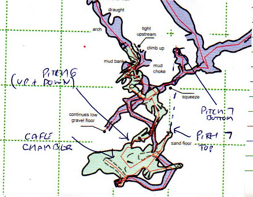
In August 2019, Jim Lister and Mark Smith dived Bassenthwaite Water at the end of First South Passage on 22nd, 23rd and 25th August. The sump is about 30m long with airspace over most of it. Footprints were noticed halfway along, confirming that earlier explorers had dropped in from above. A large, muddy stream passage leads off for about 100m with lots of necky climbs up muddy ramps. One pitch found which dropped into "many metres of streamway". The whole extension was surveyed as batch 19-01, with a length of 529m. The finds are mainly heading south including a stream way going upstream. Downstream will need digging of the gravel fill but there is no draught. (More complete description, Jim? - after the survey is published?) See also August 2022, below.
Note from Simon Cornhill:
I’m guessing that the very start of 2019 data is at the other side of the Bassenthwaite Water duck at water level (2538-19-01.0) and they did an (estimated?) leg of 6m back through the duck (bearing 61°, elev 0°) to station 2538-19-01.a. However, this station is tied into the main centreline at the end of Dave Milner’s survey (2538-13-01), where it looks like he was 6m above the duck. So, it looks like the relative elevation and position of the new 2019 stuff could be somewhat inaccurate.
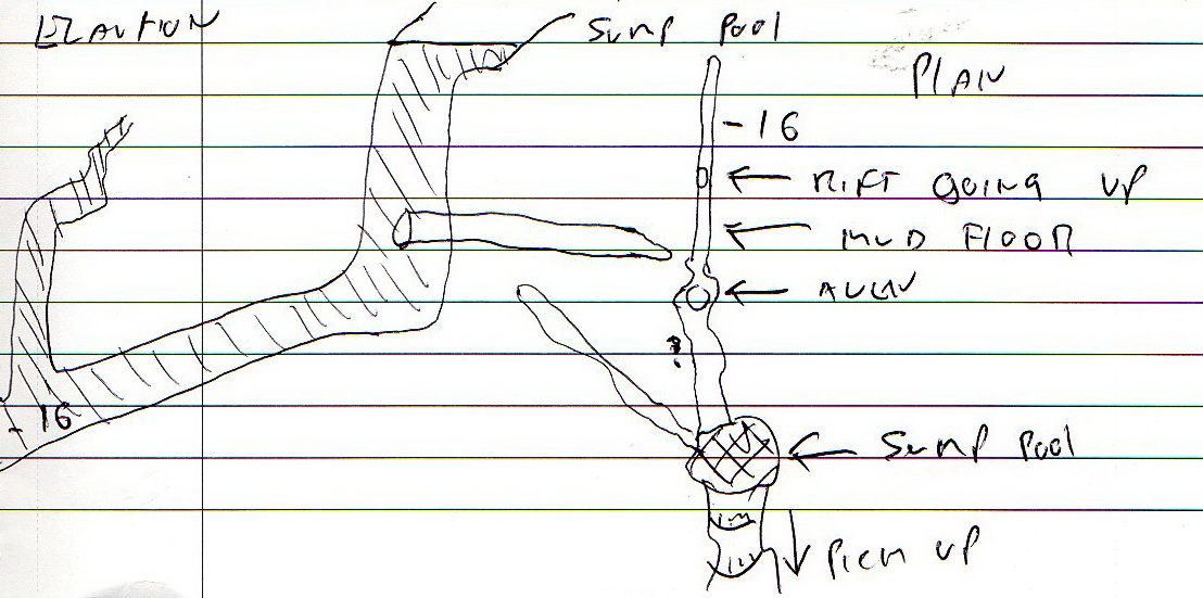
Further work over 7 trips through Bassenthwaite Water were carried out by Jim Lister and Mark Smith in August 2022. The downstream was dug out and capped and eventually, through a crawl (52m long), a 20m pitch was reached. At the base there is a sump pool and, over 3 dives, no way on was found (with very poor or no vis) in a complicated sump. It was dived to -16m. The survey batch 22-01 reaches the head of the p20. Logbook sketch here. Jim Lister wrote, "Mark tried to duck under roof but found it to be a vertical shaft going straight down. Team had rest day to let water clear which it did not. Jim dived to -16m; passages leading off closed down but interesting vertical rift going up in roof! Jim dived day after. Sadly it closed down just below what felt like surface, the sump will go but we have missed something!!!! Need some visibility to find way on!"
The plan for future trips is, "Take dive kit down on day one of expedition including bagged up wetsuits. Return a week later take muddy cave kit off before streamway, kit up and dive."
A survey error was also noted: The vertical "Pitch 7" (pitch top @ 2538-19-01.cub_2.8; pitch bottom @ 2538-19-01.cub_3_bottom_of_shaft.l) are 36m horizontally separated and the pitch top is 16m below the base! The error can be seen in the Survex file and is shown on this survey piece.
Simon Cornhill has spent some time looking at and correcting anomolies. The results are shown in the Easter 2023 Survex and Detailed Survey below.
April 2023: A trench was dug at the far side of Bassenthwaite to lower the water. "The sump now has airspace above it." The sandbags filled with sand and gravel were also placed in the downstream "continues low gravel floor" creating a dam to hopefully prevent more sediments washing in.
Refering to the 2019 survey, (where there are more names than in the description above):
Part way up Mud Stairway, a passage to the north was surveyed as batch 23-01, a "lovely" mud-filled passage which splits into two with both routes soon ending. (Length 39.8m)
The centre line with no passage detail - to the west of Second North West Passage - was resurveyed with detail as batches 23-02 and 23-05.
Batch 23-03 is an inlet that goes off the second p19, about one third of the way down. Climbs up end a choke of calcited rocks. There may be a tight way up. (new 22m).
Batch 23-04 is a short length of passage (off the re-surveyed 23-02 / 23-05) to a too-tight rift.
Full details of these 5 batches will appear in the 2023 Easter update to the survey.
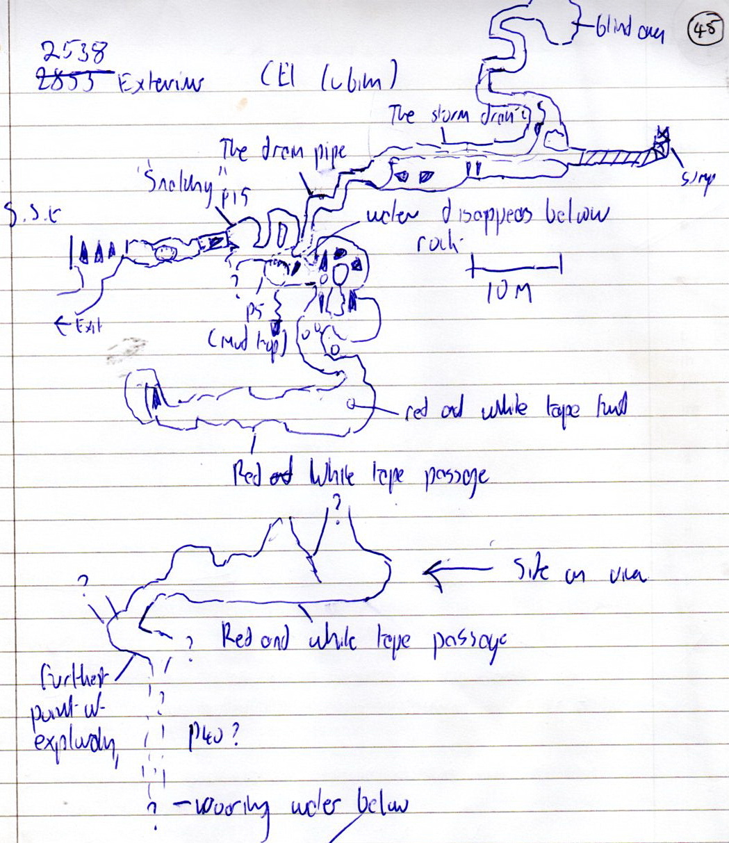
August 2023: Two trips in August 2023 explored down a 15m pitch ("Snatchy") off station 2538-12-03.6.19. This enters an aven with "lots of small streams entering". A p5 drops into a strongly-flowing streamway. Downstream is immediately too tight but there is possibly a clamber up which may bypass it. (1) Upstream started small but entered large passage (stn 0) ending at a sump(2) and, to one side, an inlet passage that ended at an aven (stn 14).
(1) A combined tactics climb from the base of the p5 enters a series of muddy chambers before breaking out into large passage. There was a piece of red and white tape on the floor but no footprints, so the tape could have fallen from above. After 20 - 30m, the slope reaches the head of a tight rift p40(?) with the sound of a roaring stream below.
(2) The sump was investigated by Mark Smith and starts as a duck for about 15m. The passage turns a corner and properly sumps but with no belay points for a dive line.
(Although some of this extension has been surveyed, it has not been tied back to a known survey station due to equipment failure.)
[Info from Alex Ritchie]
Sketch of extension (p45 logbook)
March 2024: Third South Passage The connecting passage batch 24-01 was surveyed to tie in batch 23-06. At the final pitch to the north (24-01.33), although a 50m rope was taken in, it became "way too tight" down 6m. There is a loud sound of water out of sight an unknown distance below. The survey shows this point as being on the other side of the sump.
It's worth highlighting the fact that the aforementioned pitch is a significant prospect in this cave and for the expedition in general. Cubillón takes a really significant draught, far outsized for what you'd expect for the known size of the system, and a healthy portion of said draught is observed at the top of the pitch which was found to be too tight. Capping this pitch is a truly miserable prospect, as is even getting to the top of it, but there is every indication that someone both brave and stupid enough to do so could be well rewarded. Equally, they may be rewarded with simply capping the next rock protrusion instead. The level of sticky mud encountered in this area of cave cannot be understated - using any sort of electrical equipment, such as a Disto or a drill, should be done only with a device for which the owner cares not if it should break. It may be worth looking at the survey in detail to see if an easier way into this area can be found - indications are that such a way may exist, as red flagging tape was found near the pitch head (potentially dropped from above), despite the rest of the chamber clearly being "new" cave. [Andrew Northall, logbook 27/3/2024]
Right by where the above new section takes off from the new passageway, there is a mud and boulder choke immediately adjacent to the passage. A way on can be seen down through the choke but this would be extremely dodgy considering the material composition. Approx. 10m into this new section there is a hole to crawl up to and through to get to the first pitch head. Once through a bridge climb can be seen leading back towards the main passageway, but it is uncertain whether this goes back into the main passage or into a separate passage above. Greasy climb, would need a bolted line for cowtails.
[Sam Davis, logbook]
All the survey pieces were brought together in a drawn-up survey by Diane Arthurs and Simon Cornhill in July 2016 and updated after the August 2019 discoveries. Note that the p30 down to Tilberthwaite is not labelled on the current survey and that there was a major error at "Pitch 7". (See above.)
Link to entry in the Cave Diving Sump Index.
References: anon., 2006d (summer logbook); anon., 2011e (autumn logbook); anon., 2011f (Christmas logbook); anon., 2012b (Easter logbook); anon., 2012e (autumn logbook); Corrin Juan, 2013a; anon., 2013b (Easter logbook); anon., 2013d (summer logbook); anon., 2014b (Easter logbook); anon., 2014d (autumn logbook); Papard Philip, Corrin Juan and Smith Peter, 2014; anon., 2015d (autumn logbook); anon., 2016b (Easter logbook); anon., 2016d (autumn logbook); anon., 2017b (Easter logbook); anon., 2019d (summer logbook); anon., 2019e (autumn logbook)anon., 2021a (January, February logbook); anon., 2022c (summer logbook); anon., 2023b (Easter logbook); anon., 2023c (summer logbook); anon., 2024a (January, February logbook); anon., 2024b (Easter logbook)
Entrance pictures : yes : distant views
Underground pictures : yes : Easter 2012 : Easter 2013, Lake Tilberthwaite climb above sump : April 2023 : August 2023: Third South Passage : August 2023 1st South Passage : Easter 2024
Videos : Exploration beyond Bassenthwaite Water, 2019 :
From 2022 on YouTube - Mark Smith in the crawl to the head of the new pitch : Jim Lister capping crawl : Pitch descent and sump 2 at base : Mark Smith diving sump 2 :
August 2023: route to Second South Passage & exploration in Third South Passage (YouTube)
Detailed Survey : pdf file (November 2011) : projected section (line) pdf : Easter 2012 (in preparation) : Data - including info not yet on survey : annotated, Easter 2016 : July 2016
August 2019 (note error mentioned in August 2022 section.) : Easter 2023 (errors corrected and more detail) : Easter 2024
Line Survey : on aerial photo : on map (note differences between the two)
On area survey :
Survex file : 2024 Easter now includes 23-06 with the tie-in section 24-01 (note error mentioned in August 2022 section.) (Amended magnetic declination December 2013 to align with Eur79 grid and coordinates altered to fit ETRS89 datum, April 2014.)
Passage direction rose diagram: 1/7/2018