Updated 17th October 2004; 7th October 2006; 16th April 2008; 26th June, 4th, 14th July, 22nd October 2010; 27th May, 21st June, 14th October 2011
A depression on the opposite side of the road from the farmhouse. The first
notable feature is the centre opening which draughts out very strongly. This
has had some boulders removed and the crawl inside splits. To the left, the
passage enlarges and ends at a draughting choke that probably requires a
cage to progress. Photos of this area were taken in 2006.
To the right, The Sewer is entered - a flatout, confined passage which, by 2008, was 40m long downstream and has been "left wide open with good draught".
This route is not a passage to push if
it is raining. This was shown at Easter 2008, although the route was made
a bit larger.
The second feature is the rift some 40m above and to the left of the first.
This opening in a 1 x 2m limestone outcrop drops in a very narrow,
sharp, spikey rift to a choked floor (about 20m?). A narrow rift continues
back up the other side. There was no noticeable draught at Easter 2004. This has been given a separate site number - 3349.
Over Easter 2010, the cave was extended downstream through very tight squeezes in a crawl and up an inlet into large, old passage. A survey was carried out and the following description produced:
The entrance is located under a rock arch at the base of a drainage gully. A flatout crawl over cobbles soon reaches a junction. Straight on enters a medium-sized chamber choked at the far end - a possible dig here will require care. Bats have been seen in this area.
Back at the junction, a right turn leads into The Sewer proper. A constricted crawl past a dog-leg and right hand bend reaches a small cascade, immediately followed by a narrow entry into the first squeeze, the U-bend. More flatout crawling reaches The Sludge Digestion Unit, a technical squeeze that is more difficult on the return. Five metres of awkward thrutching ends at a slope down and drop into a pool. Easier going reaches a further pool out of which is the final squeeze, The Septic Tank. The passage soon enlarges at a confluence.
Upstream is Effluent Inlet, low for 15m, before a climb up to the right through the Manhole. This enters a large chamber, a large fossil passage about 8m wide and decorated with stal at its northeastern end. At the opposite end a small passage heads off and rejoins Effluent Inlet upstream of the Manhole. This connection is unsurveyed. The passage soon ends at a draughting dig.
Downstream from The Confluence passes a curtain on the left and continues, walking-size, with occasional stooping for about 60m. At one point it is possible to climb up an aven series (Filtration Aven) containing a vertical tube in the roof and a horizontal dig. The final chamber has a blind 8m aven and two squeezes in the streamway drop into a loose, choked area where access back to the stream requires the removal of blocks by capping.
The streamway flows on a sandstone bed and trends in a northeasterly direction into the hill.
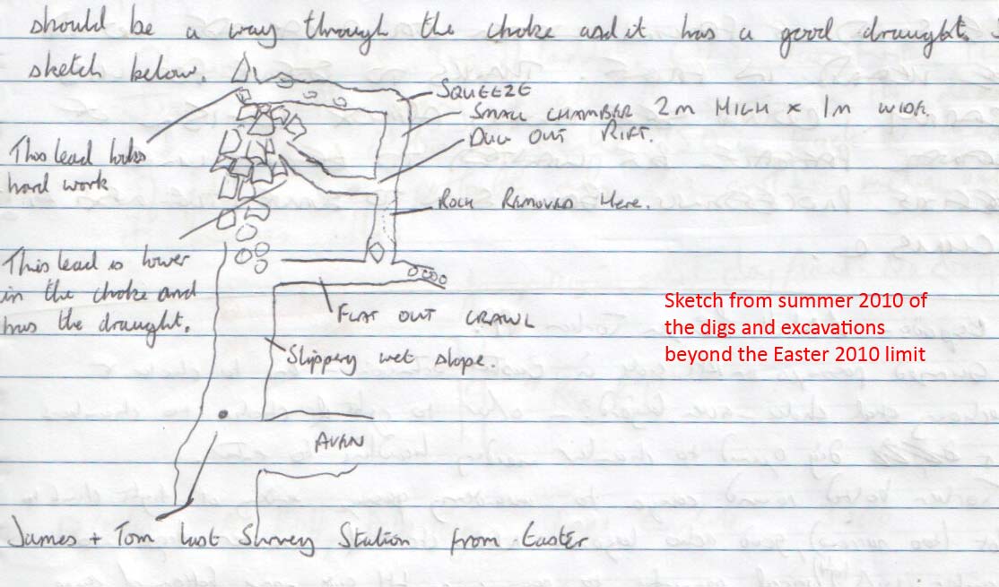
This downstream area was excavated in the summer 2010 when the right hand wall was removed and rubble dug out. Beyond is about 10m of crawling to a choke with voids below. A draught is also felt in the floor at the excavation and this revealed a rift which was opened up to about 15m of passage ending lower down in the choke than the first lead. With more time and effort there should be a way through the draughting choke. (Sketch).
Further progress was made in June 2011.
A diagram of the hydrology of the San Antonio - Hornedo - Cobadal area drawn after Easter 2011 can be found here.
Over three days in July 2011, the supposed upstream course of Fuente Aguanaz (or, at least, part of it) was dowsed. The furthest point reached was a small sink close to the entrance of the Sumidero de Cobadal. A number of inlets and sinks were also highlighted. See the links below.
Reference: anon., 2004b (Easter logbook); anon., 2004d (summer logbook); Corrin Juan, 2006; anon., 2006d (summer 2006); anon., 2008c (Easter logbook); anon., 2010b (Easter logbook); anon., 2010c (summer logbook); Corrin Juan, 2011 (survey & photo); anon., 2011c (Whit logbook); anon., 2011d (summer logbook)
Entrance pictures: yes
Underground picture(s): inside entrance : possible digging area : squalor, Easter 2010
Video:
Detailed Survey : sketch from logbook : Easter 2010, complete survey : sketch from 2010 summer logbook
Line survey:
On area survey: Dowsing reactions close to this cave : All dowsing reactions in the supposed Fuente Aguanaz catchment. (Article about the dowsing carried out in July 2011 can be found here.)
Survex file: yes (Easter 2010) (Amended magnetic declination December 2013 to align with Eur79 grid and coordinates altered to fit ETRS89 datum, April 2014.)