Updated 19th February 1999; 26th October 2001; 26th January 2005; 6th January 2011; 30th June 2018
The site was first documented in 1982. The lower cave is a resurgence in wet weather and ends at a daylight connection and a small dig.
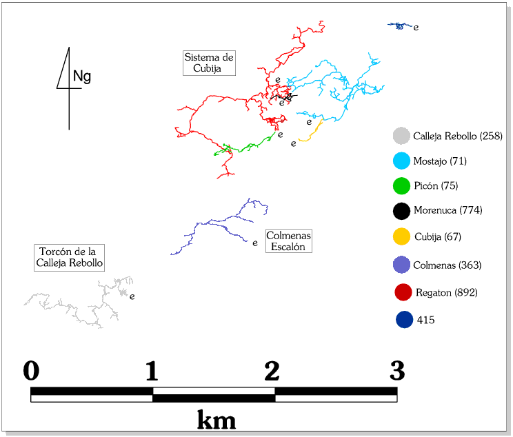
The dry cave lies 8m above the resurgence and leads to a draughting boulder choke after 20m. This was excavated at Easter 1994 to a very narrow and wet streamway which continued for about 50m to another choke. The cave was pushed over nine trips during the summer of 1994, giving over 2.3km of passage, some fossil tunnel and a link with Fuente El Escalón (280) to form the Sistema de Colmenas-Escalón (though not dived through the sump). The system is active and should be avoided when rain is forecast. On occasions when there is a small flow of water in the entrance series, no water is seen at the resurgence.
The 400m entrance series, Free Beer Passage, is generally small and quite tight and awkward in places with deep water in wet weather. One hundred metres from the entrance, on the north side, a mucky passage leads to a calcite dig. Half way along Free Beer Passage an oxbow sets off high on the right above some gours and rejoins the main passage further in. This route is easier than the streamway as it avoids several squeezes. The route continues through some zig-zag bends, past a choked aven, enlarging to The Hangover a junction at a boulder run-in and fossil canyon passage.
To the west, the large passage passes through a big chamber and under a bouldery inlet coming from roof level. Shortly after entering a well formed streamway a choke on a corner is reached which has been crawled into. The choke draughts and there is a black space in the roof on the extreme right hand side. The route (White Mischief) now heads south initially as a walking height streamway containing pools but soon degenerates to a low pebbly crawl.
Just before this, two leads remain to be pushed. On the left a draughting inlet needs hammering to enter while a low, wet passage on the right near here continues for more than 20m but probably needs a wetsuit.
Eventually a small chamber containing fallen blocks is reached and a cairn marks Cairn Junction with two small 'inlets' entering from different directions. The right hand eventually leads to a chamber after 70m with several ways off , one of which is an aven which has been climbed for 10m and continues for at least another 10m to blackness(?) Following the stream inlet further, a junction is reached where the inlet water divides. The right branch quickly reaches a draughting choke which has been passed to gain a small chamber with both the water and the draught issuing from too tight fissures. This part of the Cairn Junction Inlet appears to be the major part of the water flow for the Colmenas resurgence during "normal conditions". The left hand branch of the junction continues for about 60m until the passage becomes too tight.
Following the left hand side the going remains awkward until the passage changes and becomes more phreatic in nature.
Gradually the cave becomes narrower and gets too tight to follow except at roof level until an aven is reached, over 12m tall. (Between Cairn Junction and this part of the cave, several tubes in the roof exist. Most have been pushed and, of the ones that don't end after a short distance, they form small, high level routes which connect in various places in White Mischief below).
From the base of the aven, the passage stays at head height with much calcite flow being evident including one with surface debris present. A side passage on the right opposite an obvious white column has been entered for a few metres and is still going but very tight. Other side passages in this area all appear to end in digs or small avens.
Eventually climbing up through boulders gains a chamber with collapse and the way on is to the left. Beyond the route leads to a 40m+ aven but just before this a slot in mud(?) draughts out strongly. This is the furthest point to the west and may be the best start for a possible Torcón de la Calleja Rebollo (258) connection.
To the east of The Hangover a rubble slope rises to a large vadose canyon which drops down two 3m climbs and meets a slippy calcite slope which requires two ladders. Shortly beyond this and through a calcite window, the Playschool Series starts, the passage entering a large breakdown area with a choked rift above.
Two passages lead off from this area. the southerly route takes water through varied passage, past a sink, through a heavily calcited area and ends at a region of tree routes and bones where it may be possible to dig through to the surface. This point lies under the cliff face southwest of Fuente El Escalón (about 1m below the surface) but would probably be impossible to radio locate. There are a couple of possible features and dig sites on the surface.
To the east of the run-in, an arch in the roof enters canyon passage. Three hammered squeezes are passed to a 2 x 2m draughting and well-decorated passage. A number of right angle bends lead to a red stal column and a weird herring-bone stal on the floor, hence the name Mackerel Passage. Some 50m beyond the red column a sandy ramp leads to a passage which ends after 50m at a draughting sandy dig which must sump in wet weather. At the red column a northerly passage also closes down after some 50m.
Heading east leads to a phreatic maze area and eventually the link with the
back end of Fuente El Escalón (280), through several wet crawls.
Link to entry in the Cave Diving Sump Index.
References: anon., 1982 (logbook); Corrin J, 1983c; pers comm/anon., 1986 (logbook); anon., 1994a (Easter logbook); material in file; anon., 1994b (logbook); Corrin J, 1994b (survey); anon., 1995c (logbook); Corrin Juan, 1995a; Corrin Juan, 1996; anon., 1996a (Easter logbook); anon., 1996b (logbook); Corrin Juan, 1997a; Corrin Juan, 1997b; García José León, 1997 (survey); Corrin Juan, 1997c; Corrin Juan, 2001a; anon., 2004f (Christmas logbook); León García José, 2010 (Volume 1 and Volume 2) (line survey)
Entrance picture :
Underground picture(s):
Detailed Survey :
Line Survey : On the North Vega System line survey; no detail
On area survey :
Survex file : yes (Amended magnetic declination December 2013 to align with Eur79 grid and coordinates altered to fit ETRS89 datum, April 2014.)
Passage direction rose diagram: 30/6/2018