Updated 13 February 1998; 19th February,18th April 1999, 12th December 1999, 3rd January, 26th October 2001; 15th April, 8th June, 25th October 2002; 8th November 2003; 21st November 2004; 28th October 2007; 15th April, 29th September 2008; 3rd May, 23rd October 2009; 7th January, 11th October 2011; 19th September 2012; 8th September 2013; 16th, 23rd September, 9th October 2014; 13th September 2015; 14th October 2016; 24th February, 9th September 2017; 30th April, 1st July, 21st September 2018; 11th May 2019; 4th September 2021; 7th May, 4th September 2022; 7th January, 9th May 2023; 27th April, 18th September 2024
What follows is an incomplete description.
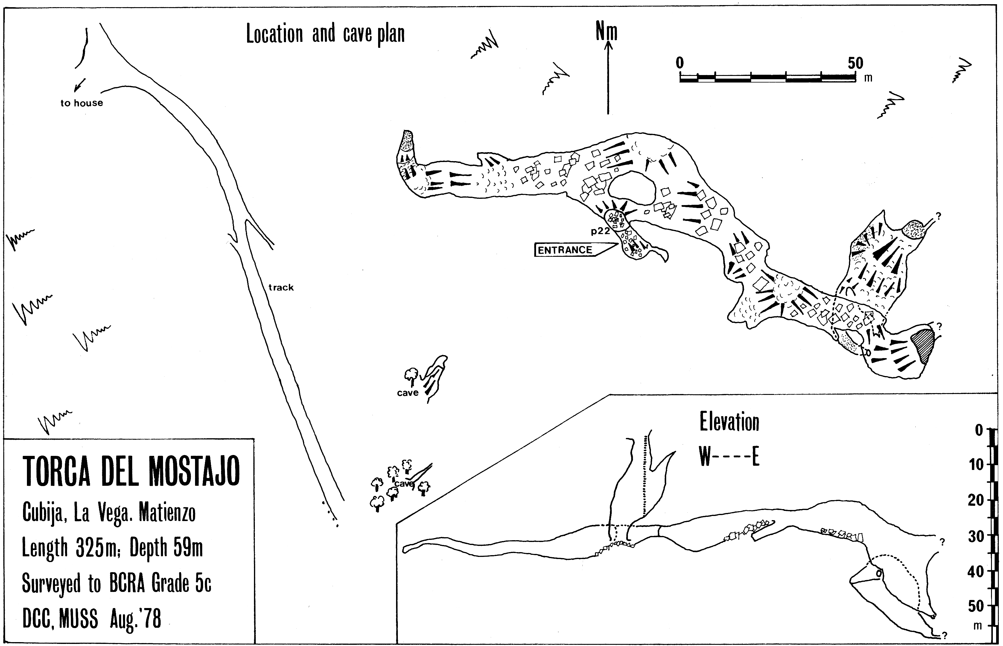
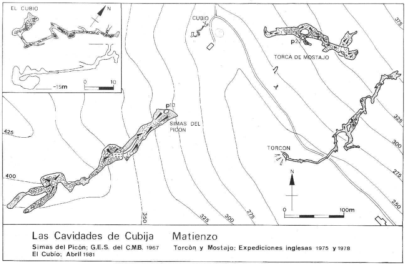
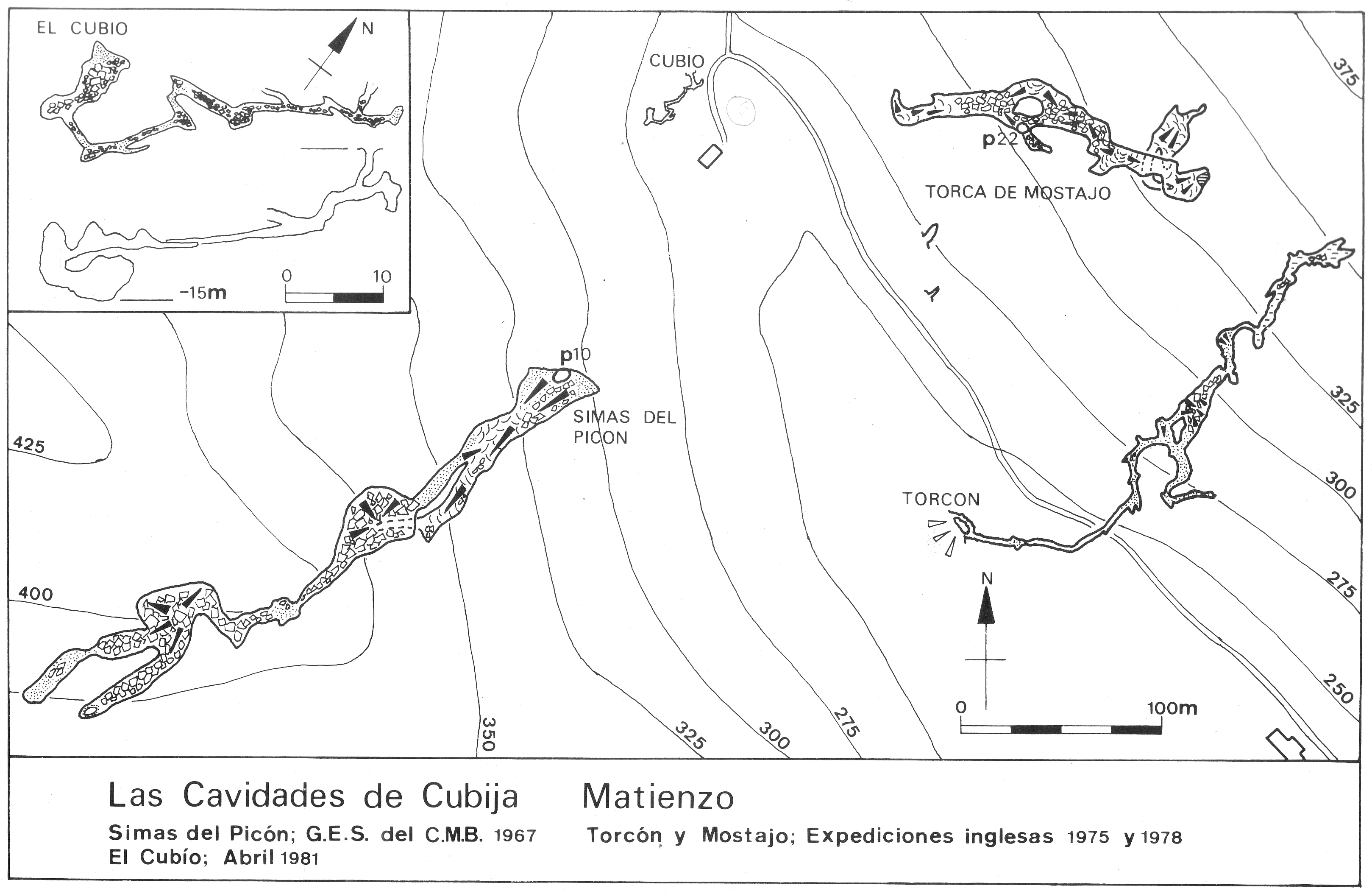
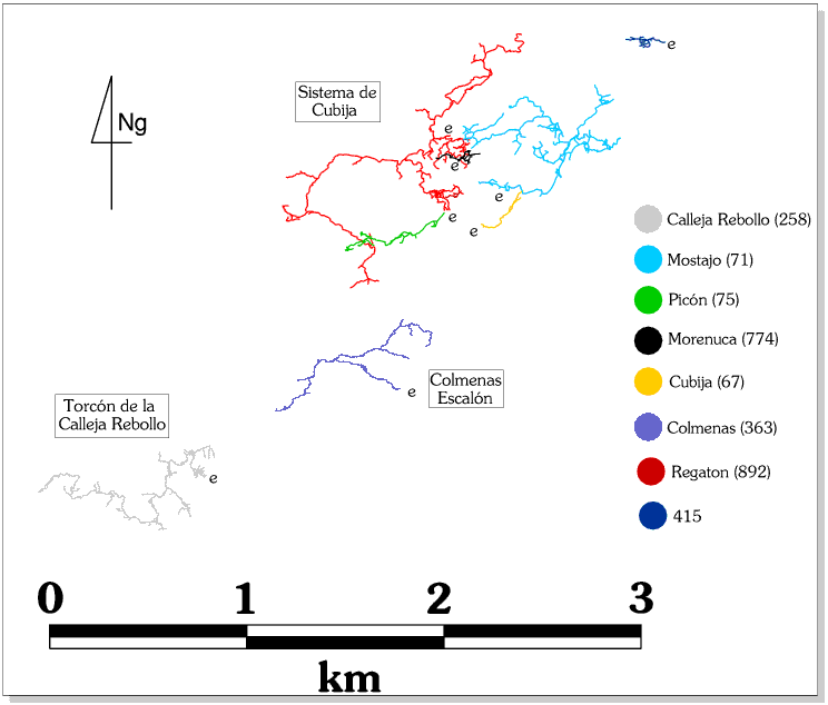
The top entrance to the major cave system in the Cubija valley. The cave is complicated on the middle level and this has hindered systematic exploration. The cave was linked with Torca Regaton (892) in 1994, and to Cueva de la Morenuca at Easter 1996 giving a total explored length then of 17023m to the Sistema de Cubija. A composite survey, showing the four caves of the Cubija System, was published in early 2017. The three traverses on the high level were re-equipped with new bolts and ropes by a Spanish team in November 2022. Each has a diagram accessed below. In 2024, it was reported that routes to well decorated sections were well-trodden with many markers.
The 22m entrance pitch from a P-anchor on the southeast side drops onto a slope of boulders with another 5m drop to a stony slope. (In 2017, it was noted that the 22m entrance pitch requires a 45m rope to rig. Whether this includes the final 5m drop is unclear.) New P-bolts were noted on the entrance pitch when visited at the end of March 2024.
To the left, in 7m square passage, is a choke after 50m; to the right is the main route which ends after 200m at a perched boulder and a steep slope down to a pool. This was the original end. Five years after its discovery this slope was scaled and climbed to the continuation. The climb is now bypassed by using the roped traverse on the left hand wall (replaced in 1993, and in 2022 by a Spanish team). This clings to the top of a 30m high calcite slope and ends, after some 60m, at the sandy floored and draughting entrance to the 1983 extensions. Traverse detail.
Comfortable mixed caving, mainly on a sandy floor, leads past some nice stalactites, long helictites and a long straw formation. In a chamber, a 3m ladder or rope foot-loop climb up on the right hand wall enters a short length of passage which descends to a tight, strongly draughting crawl which took 6 days to excavate. (In October 2008, the crawl had "filled up" and required some re-excavation). This flatout section lasts for only 20m; the passage then breaks into the typical Matienzo tunnel, with a gypsum floor and initially, many formations. Part way along the crawl, to the right, is another crawl which opens out to a squatting height chamber. A duck under the right hand wall enters a crawl to a metre high passage which closes down.
The main passage passes around the side of a number of holes but the main obstacle is, after 300m, The Pit, an awkward traverse down into, and up out of, a sandy walled drop. The climb out of The Pit is laddered and was retackled in 1995. The rigging was replaced in November 2022 - traverse detail.
The tunnel, equally large on the other side, almost immediately meets another, more easily negotiable hole. This was re-equipped in November 2022 - detail here. The forward route enters a large chamber with apparent carbon films over mud layers. A smaller section enters a boulder floored tunnel which chokes with a possible passage in the roof. This is the most NE extent of the passage at 290m.
Near the end of this passage, a 10m climb up (down?) on the NW side leads to pitches reaching an ultimate depth of 100m. At ???m a phreatic level is encountered but chokes with calcite after a short distance.
In this area, in the summer 2012, the extension off the main level was partially re-explored and pushed down a climb into a new series which heads southeast. The following description of the MUSC Series has been written by Adam Sharples. Complimentary sketches of the first day's explorations in 2012 are found here and here. Surveys have been drawn up and await a resurvey of the whole cave.
MUSC Series (2012 - 2013 - 2014) (Adam Sharples)
(An account of some MUSC and Black Rose CC explorations in the series has been previously published in a Black Rose journal.)
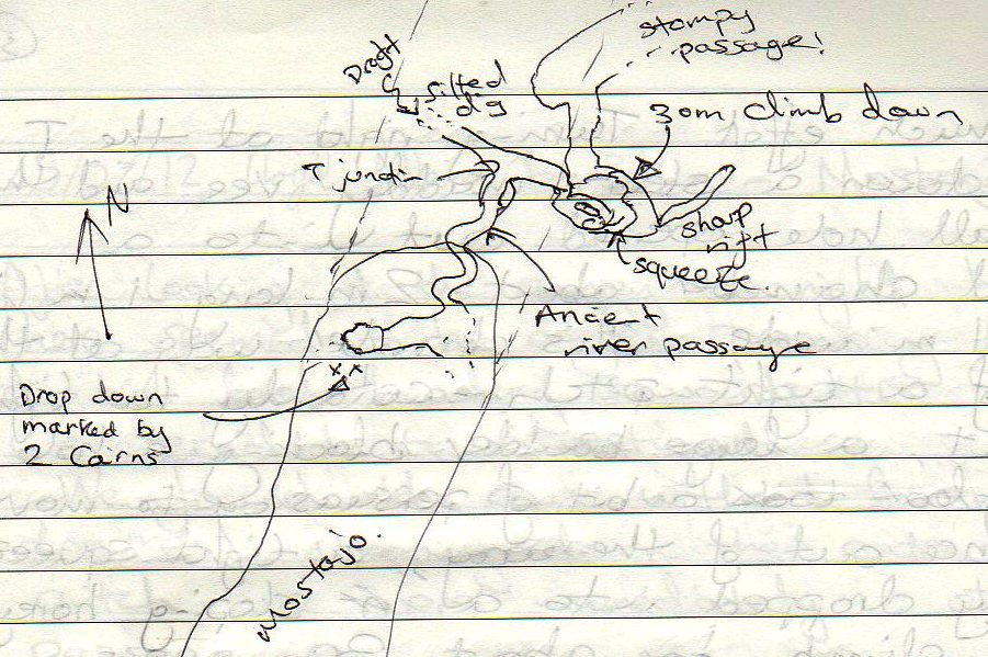
Just before reaching the current end of the wide upper level passage, are a couple of large boulders forming a wall. To the left just in front of these is a hole down, currently marked with two cairns nearby, one of which has a note of paper detailing it as a survey point, and a large mud arrow studded with rocks pointing down into it.
Inside, the passage winds underneath itself, down an easy climb, through a minor vertical squeeze, which can be bypassed by a crawl to the right, through a small drop down into a surprisingly out of place looking, sinuating ancient streamway. This is followed for a minute, to a short crawl at its end, and more traditional passage. A drip from the ceiling here has created a trench that needs stepping over, but can be used to collect water while exploring further into the cave. Over the drip hole, a window looks down a steep, muddy V-shaped trench that leads to the blasted breakthrough. You can either drop through the window down into the trench, or take the easier route to the left under a boulder that bends right and leads straight down.
At the bottom of the trench an S-bend leads into a small 2 man chamber with an over-tight vertical pitch to the left, and a blasted continuation down at floor level to the right. This is best negotiated lying on your right hand side and immediately turns into a climbing pitch. As of writing an in-situ handline is installed down the climb, but care must be taken, as the ledges are good but infrequent and muddy, and are now covered in shards of blasted rock from above.
(Batch 0071-22-01 fits in about here? Links to station 12-01.31 at the base of The Shunt climb. A clean drippy rift requires a traverse around a corner to a muddy crawl. The base of the rift is about 10m down.)
Eventually exiting to the right (looking down the climb) the passage quickly reaches the top of a chamber. A difficult direct climb down can be avoided by climbing over the edge to the left and traversing the left hand wall along and down to a survey station marked boulder on the chamber floor. An abused column marks the start of this traverse at the top, and makes for a good hand hold if held low down.
At the opposite end of this chamber, a muddied 2m climb down leads left, to an unwelcome, muddy, flatout crawl which quickly opens out to rift passage, that can be negotiated by staying at a mid-high level. A large spike of rock, the 'womaniser' marks the end of this traverse, and should be passed, keeping both legs on the same side.
A 2012 survey station on a boulder marks the next chamber. To the right here, leads around another couple of boulders and a little flowstone, to a whitened floor section with a step over a gap into walking size passage. Immediately to the right here a crawling section leads off into passage surveyed in batch
"0071-13-01". Straight ahead quickly ends up in sharp walled rift with traverses around and over lodged rocks. Ignoring holes in the right hand wall, keep left to eventually be presented by a climb over a boulder using nicely cut out steps on the right hand wall, into a good sized chamber. This chamber is full of broken and shattered rock and can be loose and treacherous in places.
The safest way to negotiate this chamber is to keep in the middle to a climb up between two boulders, with a worrying hole in the floor just beneath, then heading up and left. Pick your way around these boulders so that you are still heading away from where you entered the chamber, close to the left hand wall. Here you will be confronted by a flat, mildly sloping rock, leading to a short exposed climb up, next to the left hand wall. This climb is over medium sized jammed rocks that give good holds but look worryingly short of material maintaining their position.
Bear away from the wall slightly, clambering over rocks to continue climbing up to a good stable ledge. The most obvious climb straight ahead can be bypassed by an easier, though still loose route, slightly further along the ledge to the left, leading up to the same large flat ledge above.
Heading directly away from the top of the climb over good solid ground and gradually dropping down bearing left, gives a view out over the main trunk passage. Staying on the ledge and heading down until it joins with the trunk passage gives a choice of a straight ahead, moving downhill through the large passage heading south, or a sharp right to head uphill in a northerly direction.
HEADING SOUTH
South (left/straight ahead) in the large main passage heads downhill through easy stomping large passage with opportunities for new leads to be found. After a few minutes, a clamber down leads to a bridge with a very high roof.
Under this bridge, easy climbing down and around leads to a vertical gap between boulders looking out over a short steep ledge with a large drop below. Due to the nature of the hole, as of writing, it hasn't been possible to look over the edge, but thrown rocks fall for a couple of seconds, indicating at least a ~15m drop. This needs rope to be properly checked.
On the other side of the bridge, the passage gets smaller and changes character. Although still walking height, it becomes necessary to climb boulders and squeeze through gaps to continue, now generally heading uphill. A side passage to the left, heads to a dripping chamber with a climb up at the end into passage that hasn't been checked yet (possibly leads back to the main passage?). Further uphill in the main section, a slope up and bearing right heads into a smallish chamber, ~7m in diameter with a survey station, which was the furthest reaches of the 2012 exploration. Passage to the right here leads to a pitch, dropping into passage surveyed in batch "0071-13-02". There are other sections in this area that could do with a thorough explore.
HEADING NORTH
North in the large main passage leads steeply uphill over an edge, then back downhill into narrowing passage. At the far end, holes have not been explored but look small. Shortly before the obvious end, a flash of white rock on the left, marks a climb up into walking and stooping height passage. Other holes around here also lead into this passage. Continuing down, the passage gets smaller and changes to sharp black rock, ending up crawling out into the end of a chamber. This section is surveyed in batch "0071-13-03". Straight ahead is an obvious pit, around 20m deep, full of sharp, shattered boulders with no obvious way down at the bottom. Traversing across the left hand side of this pit, with a good thread in a hole on the left, leads to passage continuing over the other side.
This area is the most recently explored and will harbour the most new discoveries still, as well as being the least well documented. This area is surveyed in batches "0071-13-05" "0071-13-06" and "0071-13-07". Forward from the pit, a short section of walking leads to large boulders that can be easily crossed. Bearing right, following the sound of dripping water finds, initially, a somewhat clean washed pitch that can be carefully traversed to the left into passage surveyed in batch 05. Before getting to this pitch, a short climb up to the left leads into the source of the sound, a dripping clean washed pitch, over which can be connected with the above passage in batch 05. Continuing to the left from the pitch, leads into muddied rift passage, sometimes requiring crawling, an awkward slope down, and eventually drops through a smaller chamber into the larger White Rock chamber, getting its name from the conspicuous triangle of white rock placed on a boulder and used as a survey station. This is also where the above passage, surveyed in batch 05, drops into.
A steep slope to the left in this chamber arrives at an easy climb up into a maze of passages, some explored, some not. To the right, the obvious landmark of a group of three ~2m high columns in a medium chamber gives a good waypoint. There is also a survey station here, consisting of a knob of stal, placed on top of the highest boulder in the chamber, with pencil marks noting the number.
On the other side of the chamber from the columns, a rift passage, initially traversing, leads to a T-junction. Left has not yet been explored. To the right, there are some sections of formations, leading to a wet pit at a right hand bend. This has not been dropped. Carrying on, the passage bends back round left and emerges into a medium chamber, with the same dark mud floor as the passage around the large pit that was traversed at the start of these surveying batches.
To the right, this chamber seems to end in smaller chambers with nowhere to go. To the left, downhill leads to a drop to a ledge and the obvious sound of dripping/flowing water. Rocks fall for a few seconds but this has not yet been explored and will need a good amount of rope, and a few bolts. Straight ahead from the entrance to this chamber is a small hole in the opposite wall, leading into a short, flatout uphill crawl. This then drops down to a very slowly flowing streamway in stooping and crawling height passage. Upstream, to the right, can be crawled through to a too-small crawl in the streamway, which seems to open out beyond and echoes significantly. The roof and walls here are solid rock, but the floor is loose silt so could be dug. Downstream, to the left, gets wetter and smaller. This has not been properly checked, but could possibly be crawled through if the explorer was happy with the increasingly aqueous passage. However, it would appear that this downstream section leads to the bottom of the wet sounding drop, detailed above.
2015 - A possible connection after the third traverse into the new extensions was investigated over the summer. Sounds could be heard in the new extension but not higher up in the cave. No original exploration or surveying was carried out.
Various climbs were carried out at Whit, 1995. Near the end at VN5095297429 a 10m bolt climb to an ascending mud ramp ended with a choked phreatic tube. Further back on the corner at VN5086997384 a 15m bolt climb on poor rock ended in a solution pocket. The
Other passages and climbs off here including the 1986
Portienzo bit, part way along top level was partly at Easter 1994. Description needed.
About 30 metres before the Pit, 4m up the left hand wall is the concealed pitch entry to the lower level passages, the Golden Void. There is a suggestion (1995) that there might be an easily gained passage at the head of the Golden Void but this was discounted at Easter 1999. In August 2017, a small extension to the southwest of the head of the Golden Void was pushed and surveyed for 55m This is Sheppard's Bush (batch 0071-17-01). It was also noted that the pitch requires a 45m rope and that 3 of the 4 bolts at the top are "shot and at least one should be renewd to allow descent on 2 good bolts".
Hedgehog Crawl is found by crossing the centre of Chamber 46 and keeping to the right until a chamber ahead is seen with the sound of dripping water. Avens have intersected the passage and two deep pits have to be traversed by climbing around the left hand side. At the back of the second aven an exposed rope climb of about 4m up a flake enters the start of Hedgehog Crawl.
The passage starts as a flatout crawl through and over stal, passing several chambers on route. After about 50m, many dried crystal pools are seen which contain the formations after which the passage has been named. ( photo 1 photo 2). An alcove on the left hand side is eventually reached which contains much sand. The way on is through a low crawl to the right hand side and a squeeze through calcite leads to several pools. The final 60m of the crawl is an uncomfortable, very low crawl over calcited pebbles until the passage forks. The right hand side continues as before and may rejoin the trade route later on. The left hand side descends a steep slope into a rift containing the marked station V20.
To the left hand side of V20 an undescended (10m?) pit surrounded by stal is located. Going up and to the right of V20 a crawl through a stal grill leads to a junction. The left route leads to a low chamber with a large, undescended pit in the floor. Traversing past on the right hand side leads to two passages that are too low for further progress without digging. Just before the pit, a 3m climb up a vertical sand bank gains a chamber with several ways off. This needs pushing and surveying. A small crawl to the north of the pit rejoins the main way on further up the passage.
On the right, the possible continuation of Hedgehog Crawl rejoins, and the draught can be followed through a low crawl to a sandy tube that breaks out into a T junction (station 614).
To the right leads to a series of chambers and passages. This obvious, low, calcited passage may be followed to a continuation through abundant gypsum for about 200m to a dig. Just before this point a pit in the floor may be descended for about 20m until it gets too tight. this whole section has a draught that appears to switch randomly and also contains one rat (?) skeleton at its start.
The second left hand passage enters a low chamber containing fallen slabs and a climb down at the left hand wall drops into passage just near the connections with Regaton and Morenuca. Continuing on, a chamber is reached with two ways out. At the back, a crawl leads to a collapse area which connects with the previous low chamber. The right hand passage eventually ends at a calcite choke after a free climbable negotiation of a pit in the floor. Shortly before this, a crawl up a sandy bank on the right leads to meandering fossil passage which currently ends at an 18m pitch with an unpushed continuation on the other side. A traverse requiring a little protection, or dropping the pitch to a possible lower level is required to follow the good draught in this area.
The left hand side of the T junction leads immediately to a 4m roped climb into a large passage. On the right hand side a large aven bisects the passage creating a pitch down. The large aven continues up for about 15m and is, in total, about 40m deep. This is the Italian Pitch, first explored in 1985. The connection to Torca Regaton (892), discovered in 1994, is about 20m down from the last rebelay and 20m up from the floor. A short pendulum to the opposite side of the shaft lands on an obvious big boulder (station 930 in Regaton). Regaton may be gained by entering a small passage at the back of the block lower down.
Traversing around the left hand side of the Italian Pitch gains the continuation of the passage. To the left a crawl leads to a complex area of tubes which has only been partly explored. Passing under a climb up on the right hand side to a low chamber which connects further back, a large, steeply ascending ramp is reached. Climbing the ramp is most easily done on the right and, at the top, a tricky traverse meets a large, truncated roof tube. To the left of the ramp top a collapse area is reached but just before this, on the right, a tube may be climbed into using combined tactics. This is the connection with Cueva de la Morenuca (0774).
The Eastern Series on the middle level was extended in 1991 to its most easterly point by dropping a 12m pitch into a series of rifts and boulders, ending at an altitude of 215m. In 1999, further explorations in the eastern Series showed that there was still work to be done in this area. See the log book.
The 1992 explorations added a small amount but the survey needs tying back
in to a known point.
In the summer 2017, Wonderland (to the north of the middle level) was revisited. It was considered that the draughtless choke would be a big job.
Over Easter 2018, a couple of trips were made down the Golden Void to try to find another route into the MUSC Series. This was unsuccessful but some discrepancies were noted on the survey, for example a series of stations annotated with a "p" underground had been mistakenly interpreted as pitches. These and other amendments are shown on pages 20-23 of the Easter 2018 logbook. This area was resurveyed as batches 18-03 and 18-04 in the summer.
On one unusual trip at Easter, the entrance SRT rope was found to have been scorched by a farmer's fire. After replacement and descent, the passages leading to the Golden Void were found to be smoke-filled and the trip was eventually abandoned. (There are places in Mostajo where extensive black surface deposits are seen. It is possible that this the result of smoke particles settling out from many fires. There are some "shadows" in these areas - places, possibly up-wind of projecting rocks, where the black deposit is absent.)
Over Easter 2019, two trips were made continuing the explorations started the previous year. A pitch with water running down was descended near station A27 but no way on was found.
A pitch at station marked PP0 to the west of Hoodoo Haven between the Golden Void and the Manchester Series was dropped. A dry stream passage was followed upstream to a sump and downstream to a sump. This is known passage but with no previous survey detail. Of the 320m surveyed in batches 19-01 and 19-02, 157m was new passage. This passage is likely to be the same as the dotted passage shown on the survey with no passage detail etc? These explorations extended the length of the North Vega (Cubija) System to 22596m.
Three trips were made in the summer 2021. The first "down the Golden Void, across traverse with hemp rope, through the squeeze and down the sloping, muddy pitch". Several passages were pushed hoping to connect with the MUSC Series. In batch 0071-21-01, 68m of new passage were surveyed, adding to the high levels in batch 19-02. (Batch 21-01 appears to have no survey notes or drawing).
On the second trip - into the MUSC Series - batch 19-02 was surveyed for 29m off station 12-02.0. This went through a squeeze to a rift and gully, but was too loose and dangerous to proceed - Voodoo Lady..
The Time Travelling Donkey Series (batch 21-03) is a loop series joining into the main passage in two places, 13-04.11 and 13-04.13, the latter being the start for the following description in the logbook by James Carlisle.
Hole down on the left beneath boulder climb at south end (just before junction into big stuff with |Northern and Southern branches). A slide down reaches a drop off onto a mud pyramid with a 4m drop on 3 sides - care needed. A scramble down through boulders gain a rift passage into a large chamber (Donkey Three Ways). Going right through a window leads to a climb down to a tight streamway or an exposed climb into a blind rift.
Back at the chamber, an exposed drop-off leads to the head of a p11 - Pin the Tail On The Donkey - down to a streamway - DGB Streamway. The exposed drop-off and the pitch can be rigged with a single 25m rope. South in the streamway ends at a blank sand wall. North leads through a narrow crawl up into a large chamber. A window at the top of the pitch also connects to the same chamber. A climb up out of the north end of the chamber leads to a large rift in Burroboros - leading to a loose climb up through a boulder choke with a very tight squeeze back into the main passage, two survey stations north of the original entry point to the new series.
According to Quin (BU pp59-62), in his magnetic
susceptibility studies, sediments from Torca del
Coterón on South Vega show similar k values to sediments in Torca
del Mostajo, indicating that the sites may have had a common morphogenic
agent and have been connected. However, the study also indicates that sediments
from Torca Regaton (892) show little similarity to
sediments from Mostajo, indicating that the sites have not had a common
morphogenic agent. This needs explaining.
Link to entry in the Cave Diving Sump Index.
References: anon., 1978 (logbook); Corrin J et al, 1978 (survey); Mills L D J, 1981; Corrin J S and Smith P, 1981; Smith P, 1981b (survey); anon., 1983b (logbook); Corrin J, 1983b (survey and photo); anon., 1984 (logbook); Cawthorne Bob, 1985b; Barrington P and Hanson D, 1984 (survey and photo); anon., 1985a (Easter logbook); anon., 1985b (logbook); Corrin J, 1986 (survey); anon., 1986 (logbook); Corrin J, 1987; material in file; anon., 1987 (logbook); Garcia J L, 1987; anon., 1988 (logbook); Davis J and Corrin J, 1989 (photo); anon., 1991 (logbook); Corrin J, 1992a (survey); anon., 1992b (logbook); Cawthorne B, 1992; Corrin J, 1992b (survey and photo); Corrin J and Quin A, 1992 (survey); Corrin J, 1993 (survey); Quin A, 1993b (survey); Corrin J, 1994a (survey); Corrin Juan, 1995b (survey); anon., 1993b (logbook); anon., 1994a (Easter logbook); anon., 1994b (logbook); Corrin J, 1994b (survey and photo); anon., 1995b (Whit logbook); anon., 1995c (logbook); Quin Andrew, 1995 (survey); Corrin Juan, 1996; anon., 1996a (Easter logbook); anon., 1996b (logbook); Corrin Juan, 1997a; Corrin Juan, 1997b; anon., 1997b (logbook); Corrin Juan, 1998 (photo); Fernández Ortega F, Valls Uriol and Maria del Carmen, 1998 (photo); García José León, 1997 (survey and photo); Corrin Juan, 1997c; anon., 1999a (Easter logbook); anon., 1999c (logbook); Corrin Juan, 2001a; anon., 2002a (Easter logbook); anon., 2002b (summer logbook);Corrin Juan, 2003c; Corrin Juan and Smith Peter, 2007; anon., 2008c (Easter logbook); anon., 2008e (summer logbook); anon., 2009a (Easter logbook); Corrin Juan, 2010; León García José, 2010 (Volume 1 and Volume 2) (survey and photos); anon., 2012d (summer logbook); Corrin Juan, 2013a; anon., 2013d (summer logbook); anon., 2014c (summer logbook); anon., 2015c (summer logbook); anon., 2016c (summer logbook); anon., 2017c (summer logbook); anon., 2018b (Easter logbook); anon., 2018c (summer logbook); anon., 2019b (Easter logbook); anon., 2021c (summer logbook); Scaife C, 2022; anon., 2022b (Easter logbook); anon., 2022c (summer logbook); anon., 2022d (Chrfistmas logbook); anon., 2024b (Easter logbook)
Entrance picture : yes - from a distance : close up view : summer 2013, installing P bolt : Easter 2018; anon., 2023b (Easter logbook); anon., 2024d (summer logbook)
Underground picture(s): Climb to Hedgehog Passage Dwarf Chamber Golden Void top
Hedgehog Passage 1 Hedgehog Passage 2 The Italian Pitch Top level formations
Pictures by Paul Fairman, along the top level, Easter 2023
Pictures by Paul Swire, below the Golden Void, Easter 2022
Pictures by Alex Ritchie & Chris Scaife, summer 2021
Pictures by Bill Nix, in the entrance series, Easter 2018
Pictures by Tom Howard, below the Golden Void, summer 2017
Pictures by Lauren Griffin, summer 2016
Pictures by Bill Smith, summer 2014 (Flickr)
Pictures by Dan Jackson, summer 2014
Pictures by Bill Smith in the MUSC Series, summer 2013
Pictures by Bill Smith in "old" Mostajo and the MUSC 2012 Series.
Pictures taken by Mandy Fu and Mike Topsom, summer 2008
Pictures taken by Bill Nix and Bill Sherrington, October 2008
Pictures taken by Chris Castle and Nicky Dennis, Easter 2009
Scanned slides from 1983 - 1985 (Frank Addis, Phil Papard)
Video : Entrance and the installation of a P bolt, summer 2013 : Torca del Mostajo (Espeleo50 - 4/3/2017 - YouTube) : Entrance fly around (YouTube)
Detailed Survey :
| 1978 | known cave | low res | high res |
| 1981 | known cave on area map | low res | high res |
| 2017 | on the Cubija System survey | ||
| 2017 | summer extension on the Cubija System survey | in hand | |
| 2018 | summer resurvey and additions | in hand | |
| 2019 | Easter resurvey and additions | in hand | |
| 2021, 2022 | Additions | in hand | |
Line Survey :
On area survey : shown on the Cubija System (North Vega System) with no detail
Survex file : download Mostajo only (after summer 2022) (Amended magnetic declination December 2013 to align with Eur79 grid and coordinates altered to fit ETRS89 datum, April 2014.)
download North Vega area survex file (after summer 2022)
Passage direction rose diagram: Sistema de Cubija (North Vega System) 1/7/2018