Updated 8th June 1998; 27th October 2001; 9th November 2003; 21st December 2008
Probably associated with Torcón de la Calleja Rebollo (258). Entrance is obviously placed when viewed from a distance, although actual location is less easy due to an uphill jungle bash.
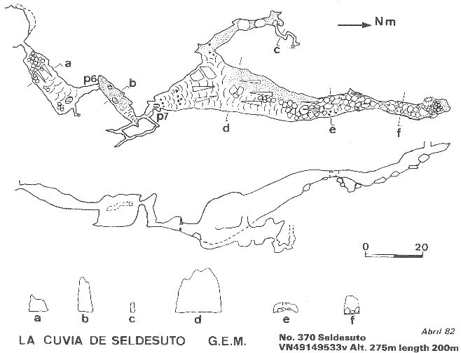
The small hole on the right of a rock shelter leads to a walk down in a large passage and the roomy head of a 6m pitch on the left. The drop lands in a roomy, sandy-floored rift. At the northeast end is a 6m climb up the left hand wall. A rope is useful for the return. A short grovel at the top ends at a 7m pitch into a calcite-floored passage which enlarges to its lowest point (20m wide). From here, a branch to the left chokes after 50m while the main route rises to a roomy, boulder and mud- floored passage with holes.
The cave finishes in solid rock; apparent holes high up on both sides have been checked out with a maypole.
A 50m extension through a tight calcite squeeze was obtained at May 95. It
is located in the left hand side wall at the start of the left hand branch
off the main passage near three columns. This was surveyed at Easter 1997
but has yet to be added to the survey. (Paul Stacey).
The rock shelter above the entrance appears to have a large archaeological
deposit including faunal remains, snail shells Cepaea nemoralis and
flints - typical of a Mesolithic site. Ruiz Cobo Jesús et al, 2008,
p195 has a photo of this level.
References: anon., 1981a (logbook); anon., 1982 (logbook); Corrin J, 1983c (survey); material in file; anon., 1989 (logbook); anon., 1995b (Whit logbook); anon., 1997a (Easter logbook); Corrin Juan, 1998; Smith Peter and Ruiz Cobo Jesús, 1999; Ruiz Cobo Jesús and Smith Peter et al, 2001; Ruiz Cobo Jesús and Smith Peter, 2003 (photo); Ruiz Cobo Jesús et al, 2008 (survey and photo)
Entrance picture : distant close-up
Underground picture(s): entrance chamber
Detailed Survey : from 1982: low res high res
Line Survey :
On area survey :
Survex file : yes (Amended magnetic declination December 2013 to align with Eur79 grid and coordinates altered to fit ETRS89 datum, April 2014.)
y