Updated 12th June, 9th October, 28th November 2005; 7th January, 15th
May, 11th June , 1st October 2006; 6th May, 1st, 21st October 2007; 16th
April 2008; 24th October 2009; 8th March, 24th June, 13th July 2010; 18th September 2023; 29th April 2024
An excavated hading fault which has a strong draught. The site was reopened
in 2005 and digging has progressed through mud into clean rocks. The site
was surveyed to about 12m deep but goes down another 3m in a hole in
the final chamber floor: this breakthrough into a low chamber with stal was
made at Whit 2006. An excavated crawl at the far end does not look promising.
A hole down between boulders require some stabilising. (A large block fell
across the top of the hole during Easter 2007). A pulley from the roof was
set up in the summer of 2007 to allow easier lifting. At Easter 2008 digging
continued with the suggestion that the draught was not appearing at the base
of the dig.
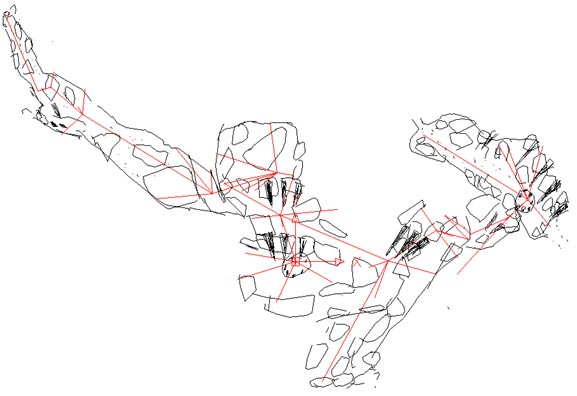
At the end of July, 2009, a large boulder was capped at the base of the dig allowing access down a short ladder to a bouldery section along and down the fault. Some reasonably stable passage was entered but most of the routes are between boulders in the extensions 70m length. At the lowest point a shaft (excavated in January 2010) was opened up by taking off projections. The route is again on the fault, sloping down at some 45 deg to a boulder dig. After moving some boulders a squeeze was passed into a large sloping passage on the fault. After some 20m it hits a wall with some straws and a possible passage off to the right (west) but this closes down. There is an excellent draught into this extension for the day (8 to 10 deg) but it was not good enough to identify where it goes, possibly down under the 'wall' to the continuation of the fault as in the first 'chamber' at the bottom of the entrance rift. The extension was surveyed at Easter 2010 but the draught was still not strong enough to suggest a primary digging place. The draught seemed to split in the final chamber and several draughting digs were started - 2 pits in the chamber and to the left and right along the bottom wall. The dig on the right was pushed 2m to where a slight drop and enlargement can be seen. It now needs a digging tray.
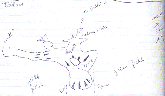
In the summer 2023 (4/8/2023), the base of the site was extended after some inspection of the pits higher up in the cave. Loose rock was removed from the draughting low point and a squeeze entered a low gallery heading east. The ceiling angle is 50 - 60° and is "mother rock". The floor has many loose blocks. After 10m there are calcite formations and 2 possible digs with visible continuations going down along the ceiling. Rocks need to be removed. The first dig is in the middle and the second at the end. The cave was found dry after heavy rain. This extension requires surveying and the length above has not been increased. A sketch addition is in the logbook and here. This area and other possible leads were re-inspected in late March 2024 and the conclusion was, "This would be a major dig using scaffolding, shoring and using major rock removal techniques."
About 100m up the hill is a small resurgence cave, site
2290. In wet weather, the water flows down the hill and sinks near to
Tablons. There are three holes (sites 2491,
2492, and 2493) below the sink
which have been excavated and abandoned.
References: anon., 1980a (logbook); Corrin J et al, 1981b; Corrin J S and Smith P, 1981; anon., 1985b (logbook) (survey); anon., 2005b (Easter & summer); anon., 2005d (Whit logbook); anon., 2005c (autumn logbook); Corrin Juan, 2006a; anon., 2006b (Easter logbook); anon., 2006c (Whit logbook); anon., 2006d (summer logbook); Corrin Juan, 2007; anon., 2007b (Easter logbook); anon., 2007d (summer logbook); Corrin Juan, 2007a; anon., 2008c (Easter logbook); anon., 2009c (summer logbook); Corrin Juan, 2010; anon., 2010a (February logbook); anon., 2010b (Easter logbook); Corrin Juan, 2011 (survey); anon., 2018b (Easter logbook); anon., 2023c (summer logbook); anon., 2024b (Easter logbook)
Entrance pictures : yes
Underground picture(s): February 2010; 2009 summer and Easter 2006 breakthroughs
pictures through 2005
Video : (Juan Corrin) dry stream and fence line running downhill at Tablons
State of the hole just before re-excavation 2005
Re-excavating near the entrance digging at the end of August 2005 1 2 3
combined video and pictures (43.7Mb download)
2006 videos: entrance and ladder descending pitch 1 2 crawl at base excavating
combined video and pictures (18Mb download)
Video during the 2009 breakthrough (17Mb)
Detailed Survey : DistoX export of the 2009 extension : sketch at the beginning of 2005 : 2010 "complete" survey
Line Survey :
On area survey :
Survex file : 3d file - after Easter 2010 (spin the elevation to show the hading fault) (Amended magnetic declination December 2013 to align with Eur79 grid and coordinates altered to fit ETRS89 datum, April 2014.)