Updated 17th December 1999; 14th May 2000; 21st January, 7th October 2001; 15th October , 8th November 2003; 1st February, 20th May 2006; 27th October 2007; 3rd November 2009; 6th January 2011; 13th September 2013; 5th February 2017; 1st July 2018; 15th December 2021; 4th May, 8th September 2022
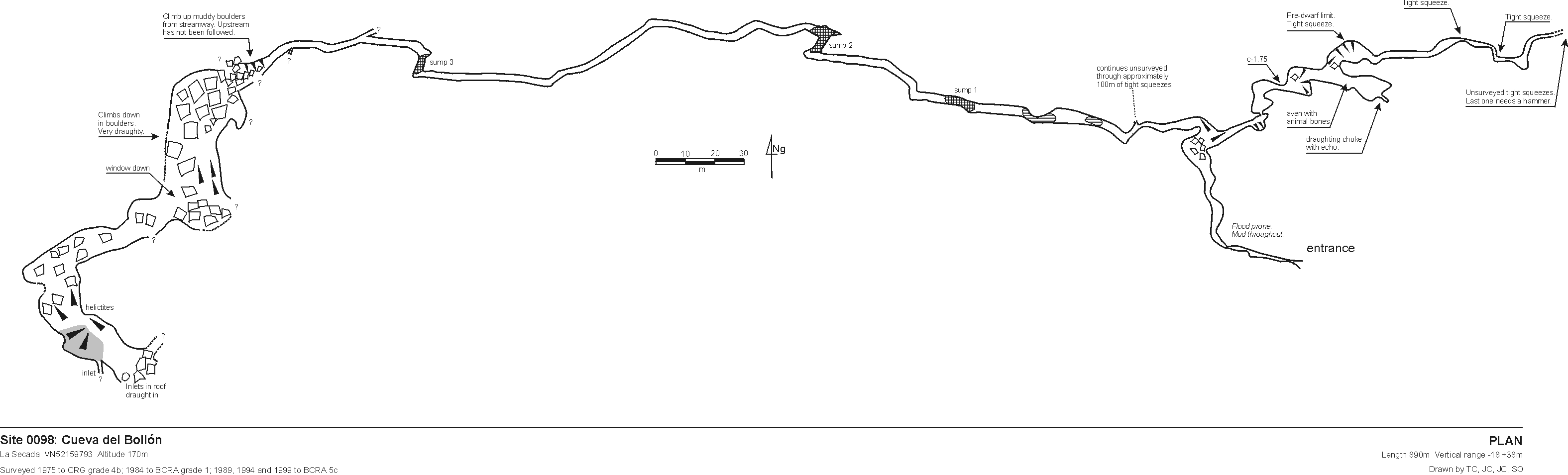
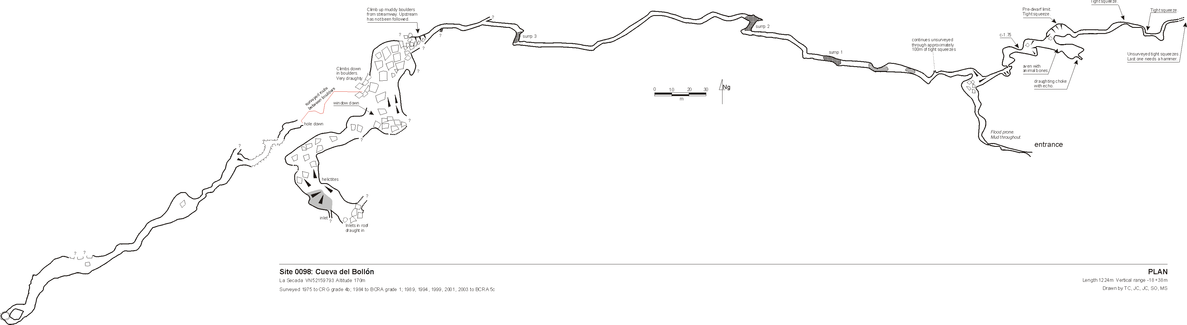
The entrance is most easily approached by walking down off the road about 100m east of the entrance then walking parallel to the road until a small valley is met. the entrance is at the top of this, under the road. The cave acts as a resurgence and floods completely in very wet weather, water resurging at the base of the valley.
A descending rift leads to a mixture of walking and muddy crawling for 70m until a chamber is reached. (See ** below.) By sliding down to the left, deepening water leads to a 3m sump which is not free-divable. This was passed in the summer of 1994 to another stretch of passage ending at a promising sump. At the end of summer 1995 expedition, this had dried out somewhat to become muddy wriggle to a steep, muddy climb out. Approximately 120m of westerly- trending, sand and mud-floored passage, ends at sump 3. Some 40m from sump 2, a passage leads off to the north for 30m ending at a boulder-filled pool.
Just before sump one, on the right hand side, a nasty, wet, strongly draughting
crawl was dug through to Passage of Slime and a muddy boulder choke.
This is passed by a squeeze and climb up to high level. Around here are two
climbs: the first is 20m in bad rock; the second needs a couple of bolts
and is safer. The draught can be followed down to a large choked chamber
with two avens. One goes to a chamber with two over tight passages. The second
could not be protected due to bad rock. "This area needs a return trip."
A return happened at the end of July 2013 where 65m of passage were surveyed (batch 13-01). This is described as narrowing down after the first pool and becoming very narrow and tight at the end of the crawl (about 20cm) before opening up into 30m of very muddy passage. The route reaches a small chamber at the end where it closed down into an impassable section that could possibly be dug. A noticeable draught was felt. It appears that the boulder choke and climbs have not been reached.
Additional notes for the above area.
To the right of the chamber, a tight squeeze at floor level on the left of
the passage leads to a succession of muddy chambers. One impassable crawl
at floor level in this section has a very strong draught. Other minor extensions
have been made (including a couple of avens - Phil Boardman - are these on
the survey?)
The passage heading east was pushed in the summer, 2013, in continuing small passage. The way on is currently blocked by a boulder approximately 1m3 in size. The way on is to the right of the boulder. A good draught can be felt and the route definitely continues. A new 48m was surveyed as batch 13-02.
In 1999 sump 3 was passed and all sumps were described as free divable with the summer water levels. Beyond sump 3, 40m of walking and stooping passage leads to the base of a steep boulder slope. There is a large amount of collapse debris and care should be taken. A short traverse around to the right at the top of the first slope leads to an eyehole 6m from the far wall where it is possible to climb down to a section of passage containing large, old stal which has fallen. Straight ahead is a blank wall but to the left is a second slope of about 30 degrees leading past a small bunch of helictites before emerging on a sandy plateau. The slope continues upwards beyond this where a Yorkshire pot-type inlet is seen on the right and other possible inlets are seen in the roof. (Explorations in this area are usually carried out through Hole-in-the-Road, site 1452).
This area is beneath sites 1452 and 898 and draughts. There are many leads and crannies to examine throughout the cave including the streamway continuation beneath boulders before the climb up (see below).
At Easter 2000, site 1452 was linked in via a 35m
pitch to where it is possible to swing across to link with the slope. Heavy
rain a couple of weeks before meant that the water levels were high at the
base of the slope and it was impossible to investigate upstream.
In the dry summer of 2001 this area could be investigated: 82m of loose,
draughting, bouldery passage was surveyed. This could possibly be pushed
by removing some of the boulders blocking the route on.
During the very dry summer of 2003, the bouldery area down the slope was
pushed further. A squeeze down under boulders to the left at the last survey
point leads to a 45 degree rift with an unexplored hole down. Over the top
leads to boulders leading eventually to a crawl under solid walls witha gravel
bottom. The passage then opens out and enters a reasonably big stream passage
down a ramp. This is followed keeping to the left hand side into large passage.
On the right avens can be seen up mud slopes. The continuing cave ends at
a large boulder collapse.
Directly above the last survey station is an aven with water dripping down.
The boulder collapse can be climbed up about 15m with a small hole in the
ceiling and a slight draught between boulders. At stream level a squeeze
gains a small chamber with a 5cm wide slot giving a view down to the streamway.
The extension length amounted to some 252m. Further extensions in 2009 are described under site 1452.
** A sump pool at the lowest point beyond the entrance rift at Easter 2022 led to the finding of two short, high level, muddy series of passages. The following descriptions by Alex Ritchie include station numbers in survey batches 0098-22-01 and 0098-22-02. Surveys are included on the latest main survey file.
1- 6 Blind Bat passage – Climb up on the right immediately inside the entrance to reach a stooping passage which quickly splits. Left goes to a small chamber with all ways on too small. Right drop's down a slope where the passage splits again and both quickly become too tight.
12 – 36 Accy Bypass – Where passage first bends to the right and lowers (was sumped on visit), a 2m climb up on the right leads into higher passage. This quickly diminishes to a tube and then a squeeze under a spike before opening up again into a boulder choke.
At station 17 just beyond this (marked) is a small passage at the same level between boulders which leads to a short and awkward and very muddy 5m pitch into a rift. All ways close down quickly with one that draft's through a very narrow rift, which descends further, too narrow. A climb up of about 3-4m, which is rather slippery gains the top of the boulders.
The way on is now to the left over a mud bank and into another small chamber with a blind hole in the floor. The way on is again up - up a steep muddy slope which leads to an easy squeeze. The passage opens into a medium sized chamber with a large hole in the floor (24, marked). To the left following the draft leads to a narrow thrutch through a rift before a 3m climb down into another chamber.
In this chamber there is a 6m climb up leading into the top of the rift, this has not been surveyed. At the back of the chamber is an opening and this is the start of the Accy Bypass pitch (12m check). Start by rigging off the flake on the left at the opening, from here the pitch drops to a ledge 3m down and a massive boulder in the rift, that serves as the re-belay. You will need a big sling to rig this. The main drop is from here down the obvious hole, but it's best to swing through the rift to more open passage 2m down, and descend from here a further 7m to the floor: rope protector needed. (20m rope, 2 slings, 1 rope protector).
This lands in the main known passage on the other side of the temporary sump. Back in the medium sized chamber (24) a loose 3m climb down leads into a jumbled boulder chamber. At the far end of this is a 7m pitch. Rig from a boulder 1m back and a secure boulder over the pitch head (long sling required). (15m rope 1 sling, 1 rope protector). This drops into a large aven chamber with a calcite slope leading up again. At the bottom of the slope is a small decorated chamber which is choked with mud. At the top of the calcite there are two possible ways on. Large rift passage can be seen up a 3-4m climb up calcite (likely needs bolts or scaling pole). Another smaller passage can also be accessed by a slippery muddy climb but this appears to lead back into the boulders above.
The villagers claim that this cave connects with the sea, as on the occasions
that it acts as a flood resurgence, it washes out quantities of sand and
shells. The end of the eastern branch appears to lie only 50 - 70m away from the
western extremities of the Western Series in Cueva de
Carcavuezo (081).
• Entry in the Cave Diving Sump Index.
References: Fernández Gutiérrez et al, 1966 (survey); anon., 1974b (logbook); anon., 1974a; Cox G, 1973; anon., 1975b (Easter and summer logbooks); Kendal Caving Club and Manchester University Speleological Society, 1975 (survey); anon., 1980a (logbook); Corrin J S and Smith P, 1981; anon., 1984 (logbook); anon., 1985b (logbook); anon., 1987 (logbook); Corrin J and Knights S, 1988 (survey); anon., 1988 (logbook); Davis J and Corrin J, 1989 (survey); anon., 1989 (logbook); anon., 1993b (logbook); material in file; anon., 1994b (logbook); Corrin J, 1994b (survey); anon., 1995c (logbook); Corrin Juan, 1995a; Corrin Juan, 1996; anon., 1999c (logbook); Corrin Juan, 2000; anon., 2000b (Easter logbook); Corrin Juan, 2000; anon., 2001c (Summer logbook); Corrin Juan, 2003a; anon., 2003c (summer logbook); Corrin Juan, 2005; anon., 2006 (Easter logbook); Corrin Juan, 2007; Corrin Juan and Smith Peter, 2007; anon., 2009c (summer logbook); Corrin Juan, 2010; León García José, 2010 (Volume 1 and Volume 2) (survey and photo); Corrin Juan, 2011; anon., 2013d (summer logbook); Papard Philip, Corrin Juan and Smith Peter, 2014; anon., 2017a (January, February logbook); anon., 2022b (Easter logbook); anon., 2022c (summer logbook)
Entrance pictures : January 2017 : summer 2022 (JC) - 360° photos 1 2 (help file)
Video : Summer 2022 - draught
Underground picture: Easter 2022
Detailed Survey :
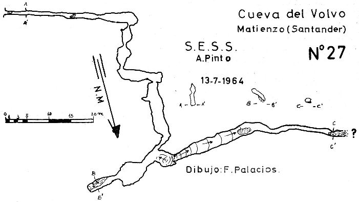
| 1964 | low res | high res |
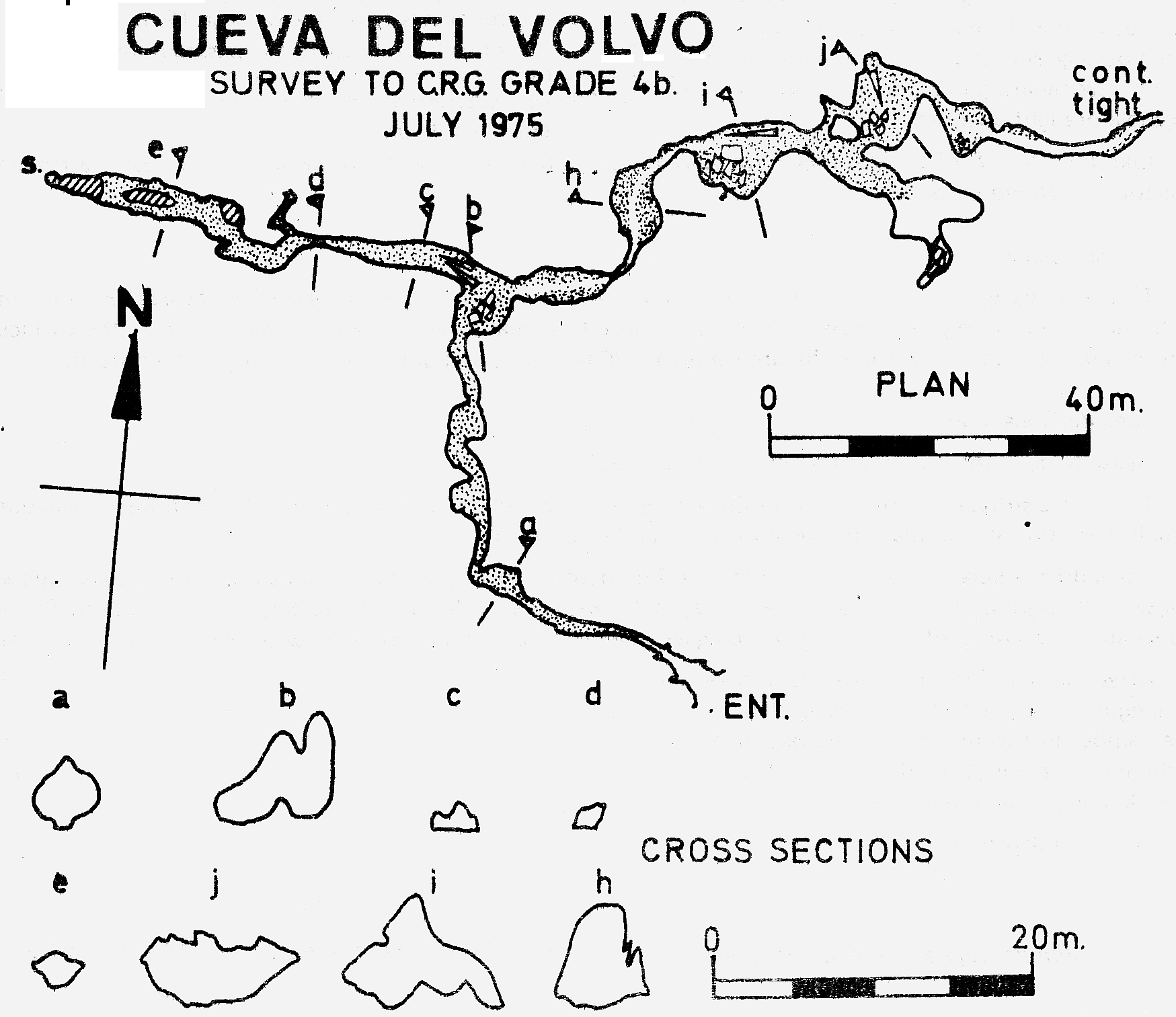
| 1975 | low res | high res |
| 1999 | 1:1000 | |
| 2003 | 1:1000 | |
| 2013 | 1:1000 | |
| 2022 | 1:1000 |
Line Survey :
On area survey :
Survex file: combined with site 1452 (May 2022) (Amended magnetic declination December 2013 to align with Eur79 grid and coordinates altered to fit ETRS89 datum, April 2014.)
Passage direction rose diagram: yes, with Hole in the Road 1/7/2018