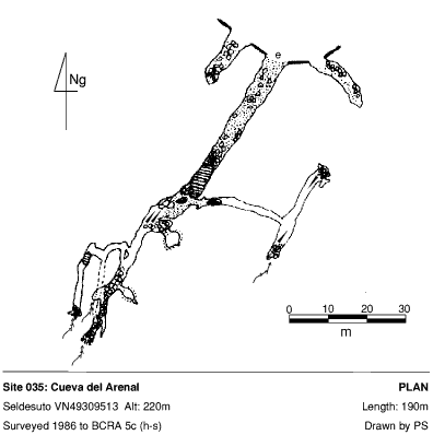
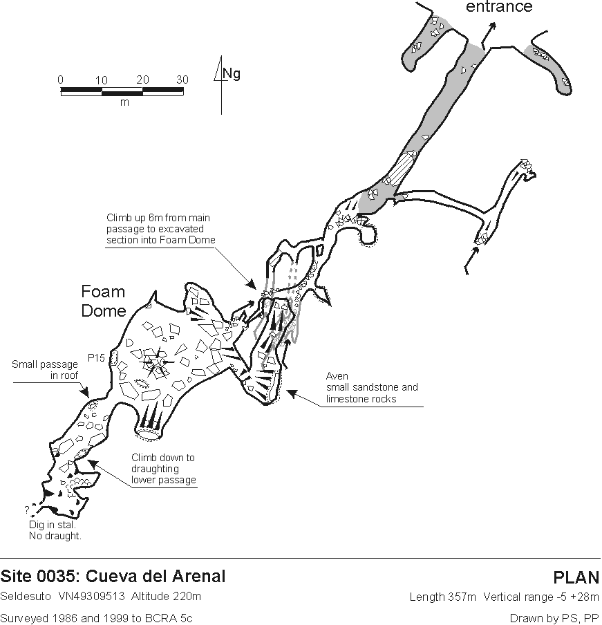
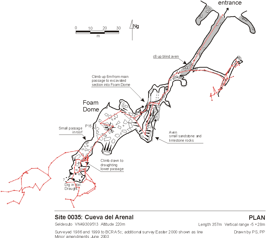
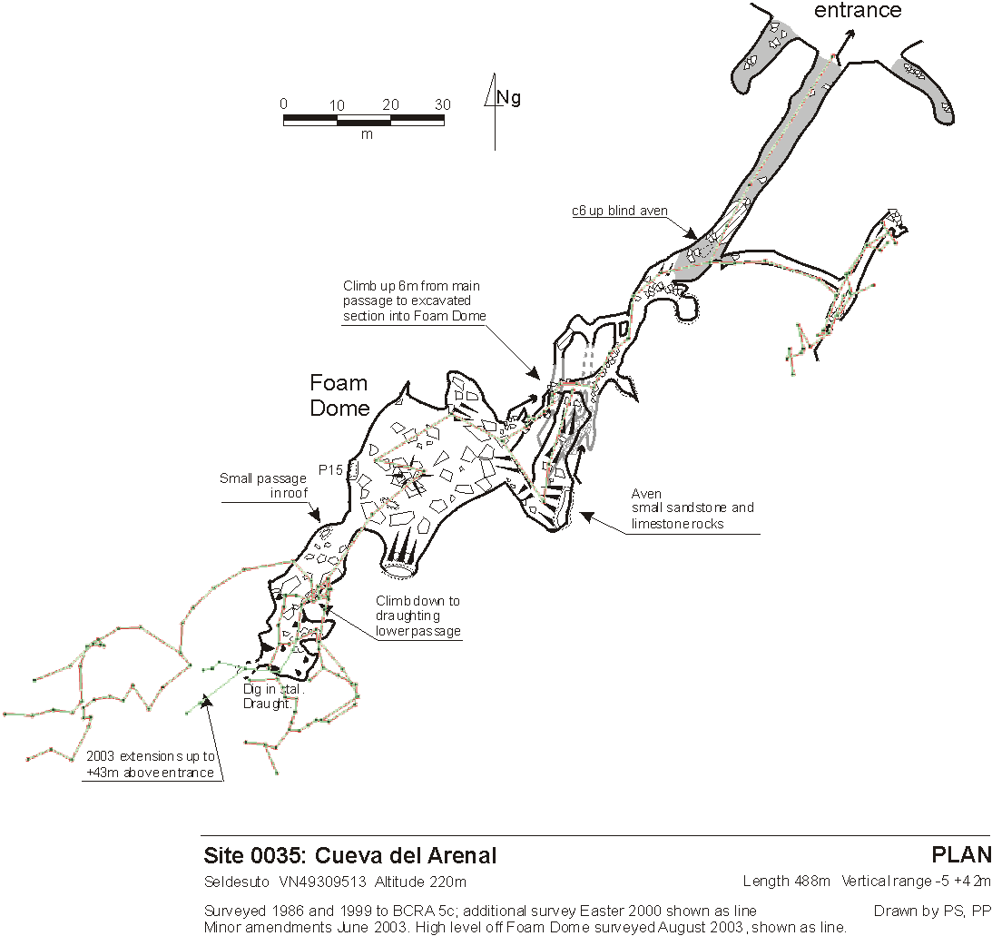
0035: Arenal, Cueva del (Callejón de Seldesuto, Cueva del)
Seldesuto 30T 449198 4794921 (Datum: ETRS89. Accuracy code: M) Altitude 211m
Length 861m Vertical
range -5m +43m
Area position : Site entrance in context : Logbook search : A Google search for this site (Arenal, Cueva del+Seldesuto)
Updated 30th August 1998; 17th December 1999; 15th May 2000; 21st January , 10th June 2001; 6th October 2002; 12th October 2003; 20th October 2004; 1st February 2006; 26th September, 27th October 2007; 20th December 2008; 23rd October 2009; 1st October 2011; 19th September 2012; 17th April 2016; 2nd September 2017; 29th April, 30th June 2018; 7th May 2023; 27th April 2024
The entrance lies above a cliff at the
top of a normally dry stream bed. Heavy rain
floods the entrance and produces a stream cascading down to the valley
bottom. During certain flood conditions the cave has been known to make a
loud sound. Presumably this will be as the draughting entrance passage is
being closed or opened up by flood waters. A visit at Easter 2018 was aborted when the entrance lake was seen to almost sump the passage. There are three entrances below
a cliff face. The outer two holes soon choke, although the eastern hole goes
in "a fair way, and draughts".
The western cave has archaeological deposits which have yet to be excavated.
A level some 40cm thick has been identified which contains enough flints
to show evidence of flint production and other items including remains of
wild boar, red deer, goat and common mussel. The site could have been in
use during the early Mesolithic period, ie the Aziliense culture. (Ruiz
Cobo Jesús et al, 2008) (Photos)
The middle (main) entrance can emit a strong draught from its sizeable ellipse.
Infra-red photos were taken in the summer 2017 showing the extent of the cold air emitted. A visit to the entrance at the end of March 2024 showed little draught
The obvious route through the main entrance ends at a solid, draughting boulder choke after about 100m.
A climb up an aven to the right (laddered from the top), just before the
main choke, reaches a short, low passage to a draughting, high, but very
narrow joint - the site that the Tortosa cavers started working at in 1995.
In 1998 further enlargement was carried out to where a small caver could
see boulders ahead. In the summer of 1999, the breakthrough came after enlarging
and excavating an unstable area which is now propped up and held together
with polyurethane foam.
An upward squeeze enters the Foam Dome, a 30 x 20m chamber with
formations. A 15m pitch has been dropped on the western side (surveyed in August 2017 as batch 0035_17_01) and beyond,
a climb down in a draughting area leads to extensions, surveyed at Easter
2000. The high level calcited area in the Foam Dome was also pushed
through to small extensions at Easter 2000. The Foam Dome appears to come
close to the base of the first pitch in shaft 491.
In the summer of 2003, the end of the Foam Dome Chamber was excavated up
a 45 degree bedding then along the strike following a good draught into a
hading chamber with no real prospects despite pushing through calcited boulders
for 6m. The total length of this extension is 50m, finishing about 43m above
the entrance level.
In summer 2007, further burrowing in the boulders allowed the explorers to
hear running water.
In July 2017, the "climb down to lower draughting passage" was re-explored and, after knocking a lump off a squeeze, a bouldery route under the Foam Dome was explored and surveyed (batch 0035_17_02). "No real way on, no real passage, just gaps in boulders. Draught lost".
The crawl to the left at the entrance pool also leads to draughting digging
sites in boulders with much potential. The digging was abandoned by the main
excavators in 1987 and was re-excavated in 1989, where the left hand series
ended at impenetrable fissures. This area was surveyed at Whit 2001.
The boulder in the right hand tube was demolished and lead to a boulder choke
which draughted very strongly.
There are two avens on the left of the main passage - have these been climbed?
According to Quin (BU pp59-62), in his magnetic
susceptibility studies, sediments from Arenal show similar k values to
sediments in Cueva del Comellante (040), indicating
that the sites may have had (or have) a common morphogenic agent and are
connected.
During the successful optical brightener water trace from Torca del Hoyón to Cueva del Comellantes in April 2016, detectors placed just beyond the confluence of the (small) resurging Arenal stream and the water flowing down the valley below gave negative results. (Photos).
The cave was thoroughly re-explored during the summer 2017 but no real prospects for extension were found. Two survey batches were completed - 17-01 and 17-02 (see above). A re-assessment of the length of the centre line now has the length as 861m.
Reference Smith P et al, 2015 has a summary of the archaeological work carried out within 2004 - 2016.
Directly above the cave is a large depression with a digging site which may repay attention. (Easter 98).
Bat information
Date: 5/4/2023
Evidence of occupation (only): feeding remains; perching evidence. (East cave)
Bat remains (number): -
Species identified name (number): Lesser horseshoe bat (1) in western passage; greater horseshoe bat (1) in central passage.
Other notes: tissue moths seen
Photos from visit
References: Fernández Gutiérrez et al, 1966; anon., 1975b (Easter and summer logbooks); Kendal Caving Club and Manchester University Speleological Society, 1975; Mills L D J, 1981; Corrin J S and Smith P, 1981; anon., 1981a (logbook); Corrin J, 1983c; anon., 1983b (logbook); Cawthorne B, 1984; anon., 1984 (logbook); Cawthorne Bob, 1985b; anon., 1986 (logbook); material in file; anon., 1987 (logbook); Cawthorne B and Neill A, 1990; Corrin J and Knights S, 1988; Cawthorne Bob et al, 1988; anon., 1989 (logbook); anon., 1991 (logbook); Neill Ali, 1991; anon., 1992b (logbook); Cawthorne B, 1992; Corrin J and Quin A, 1992; Quin A, 1993b (survey); anon., 1995a (Easter logbook); anon., 1995c (logbook); Quin Andrew, 1995 (survey); anon., 1998a (Easter logbook); anon., 1998d (logbook); Corrin Juan, 1999; anon., 1999c (logbook); anon., 2000b (Easter logbook); Corrin Juan, 2000; Corrin Juan, 2001; anon., 2001b (Whit logbook); Corrin Juan, 2003a; Corrin Juan, 2003b; anon., 2003c (logbook); Corrin Juan, 2005; anon., 2007d (summer logbook); Corrin Juan and Smith Peter, 2007; Corrin Juan, 2007a; Ruiz Cobo Jesús et al, 2008 (partial survey); anon., 2012d (summer logbook); Papard Philip, Corrin Juan and Smith Peter, 2014; Smith P et al, 2015; anon., 2016b (Easter logbook); anon., 2017c (summer logbook); anon., 2018b (Easter logbook); anon., 2023b (Easter logbook); anon., 2024b (Easter logbook)
Entrance pictures : yes : in flood : distant views
views around the entrances in 2007 during archaeological prospecting
entrances Easter 2011 : infra-red photos around the entrances, July 2017 : April 2023
Underground picture(s):
deposits at the entrance, 2012
Photos in the main entrance, Easter 2011
Various photos taken during the archaeological prospecting, 2007 and biological prospectiong, 2009
Just inside entrance entrance pool entrance pool entrance arch
passage beyond entrance pool generator 1 2
fractured wall pitch up 1 2 3 4
passage to lower level digs 1 2 Lower level tubes 1 2 3
Catalan Drag Queen Rift 1 2 foamed boulders Into the Foam Dome
Foam Dome 1 2 3 4 roof shoring foamed boulders 1 2 3
digging 1 2 shoring 1 shoring 2
Exploration and shoring in the 1999 extensions
Video: in flood
Detailed Survey : 1:1000 (old) 1:1000 (new - 1999) 1:1000 (with 2000/2001 overlay) 1:1000 end of 2003 : 1:1000 end of 2017
Line Survey :
On area survey :
Survex file : yes (August 2017) (Amended magnetic declination December 2013 to align with Eur79 grid and coordinates altered to fit ETRS89 datum, April 2014.)
Passage direction rose diagram: 30/6/2018