Updated 19th November 2008; 7th November 2009; 28th April 2013; 6th March 2014; 22nd February 2017
A couple of days were spent looking for this site in the summer, 2008, and
it was eventually shown to us in the autumn.
The 8m wide shaft is best approached
from above, where a large holm oak and 2 smaller trees are obvious landmarks
on the south side of the peak. A faint track enters the eucalyptus wood below
the two small trees and meanders down to the top of the shaft. It may well
be that the track will need a machete to clear it. The stand of trees around
and in the hole are slightly taller than the surrounding jungle. The February 2014 trip placed a Y hang for a free hanging pitch, avoiding rub points.
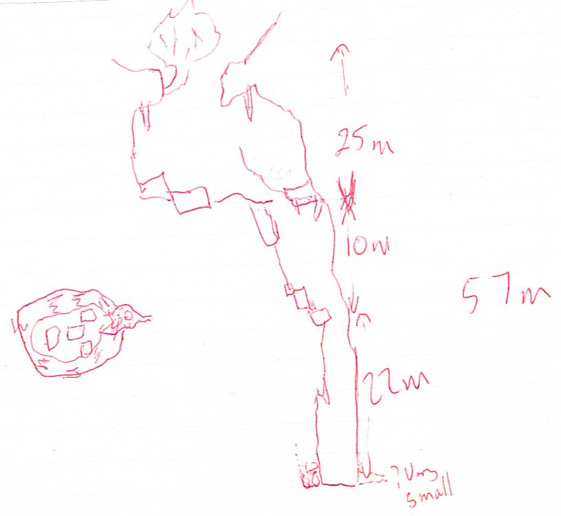
The entrance, with lots of vegetation, is on a fault/joint running 153 deg
- depth 55m. The shaft drops through a sandstone bed but opens out about
5 m down to a chamber some 15m across with very old stal. It looks as if
the cave developed below the sandstone and the roof collapsed to give the
present entrance. The entrance pitch rope is belayed to the oak tree in the
shaft and one further bolt is needed to get to the bottom of the entrance
pitch/chamber. From here the shaft drops over two blocks that have "dammed"
up the loose rubble to a clean shaft of some 35m to a mud and rock, level
floor with the small amount of water (from drips) seeping away.
A strong joint / small fault runs through the pot and there is a small passage
heading 153 deg. It may be just possible for a very small person to make
some progress along this, but there was no draught and it looked a poor
prospect. The poor prospect was excavated in February 2014 but only a small length of choked passage was entered. The site was surveyed at that time.
There is
no sign of any way on downward but the best prospect now may be to sink a scaffolded shaft into the floor.
The first exploration may have been by cavers from Santander in the 60's. It was first mentioned to Matienzo cavers in March 1997 by the mayor of Entrambasaguas.
Reference: anon., 2008e (summer logbook); page from 2008 (autumn logbook); anon., 2008f (autumn logbook); anon., 2013b (Easter logbook); anon., 2014a (January, February logbook)
Entrance pictures: 2008 and 2014
Underground pictures : 2008 and 2014
Video : from 2008 (small size) (YouTube)
Detailed Survey : sketch : February 2014
Line Survey :
On area survey :
Survex file : yes (Coordinates altered to fit ETRS89 datum, April 2014.)