Updated 15th October 2011; 28th April 2013
The farmer pointed out a hole in the wood which was not visited in 2008. Approximate
position.
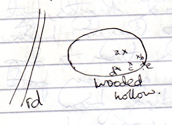
The heavily vegetated depression was visited in 2011 and 5 possible holes documented.

a: A low bedding plane about 4.5m long. Possibly draughting.
b: A low level crawl inaccessible due to a boulder and a triangular hole in the floor with a small chamber below.
c: An entrrance leads to a bouldery chamber (?) with a bedding plane and daylight seen on the opposite side.
d: A belly crawl of about 2m into a large chamber which is "boulder filled". Several possible ways to push but all choked.
e: Running water (after wet weather) sinks higher up on the SW edge of the hollow. Some boulders were removed and a cave "entered to find boulder digs within."
Two further GPS readings are:
for e: 30T 0448020 4800992; ETRS89: 30T 447918 4800783
for a,b,c,d: 0448058 4801065; ETRS89: 30T 447956 4800856
See logbook for more details, including sketches.
Another visit at Easter 2013 revealed three holes close together where the left and centre ones connect. The right hand hole enters a 3m diameter(?) low chamber via a flatout wriggle. A small trickle of water was uncovered, emerging and sinking in very small slots.
Reference: anon., 2008c (Easter logbook); anon., 2011d (summer logbook); anon., 2013b (Easter logbook)
Entrance picture:
Underground pictures :
Video :
Detailed Survey :
Line Survey :
On area survey :
Survex file :