Updated 17th October 2004; 14th October 2011; 9th May 2018
Sites 2035, 2036 and 2037 lie
inside a hairpin road bend to the north of Alisas and above site
1969. Together with site 1994
they all take water and presumbably, getting beyond the breakdown and rubbish
in the entrances should eventually meet an enlarging system.
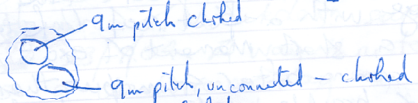
This area has 3 or 4 holes with water sinking in the upper one. The site
splits immediately and both shafts are about 9m deep and choked.
Dowsing in July 2011 failed to find any reactions on the road below all these sites. A summary of the dowsing results can be seen here.
Nearby sink, site 1969, was injected with optical brightening agent on 10th April, 2018. It was detected at Fuente Aguanaz 3 days later, the fluorocapteur proving negative the day before. (Details of the water trace can be found here.)
Reference: anon., 2004b (Easter logbook); anon., 2004d (summer logbook); Corrin Juan, 2006; anon., 2011d (summer logbook); anon., 2018b (Easter logbook)
Entrance picture: 2004
Underground picture(s):
Video: entrance
Detailed Survey : sketch plan from logbook
Line survey:
On area survey:
Survex file: