Updated 10th October 2004; 7th May 2007; 22nd May 2014; 21st May, 19th September 2017; 6th May, 23rd September, 11th December 2018; 13th May, 14th September, 31st October 2019; 22nd August, 30th October 2020; 4th March, 12th September 2021; 9th September 2022; 28th January 2025
An alternative GPS position is ETRS89: 0448206 4794622
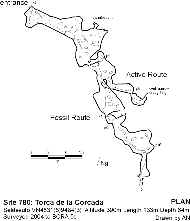
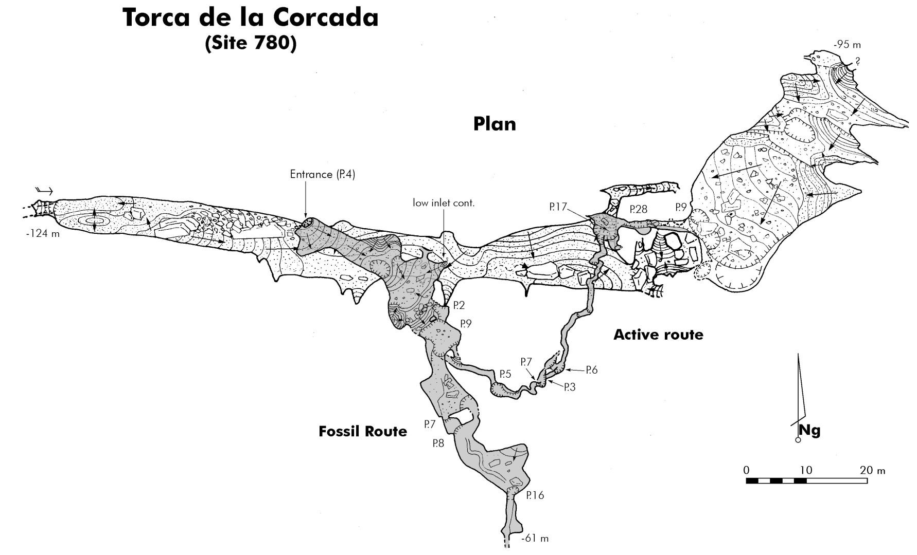
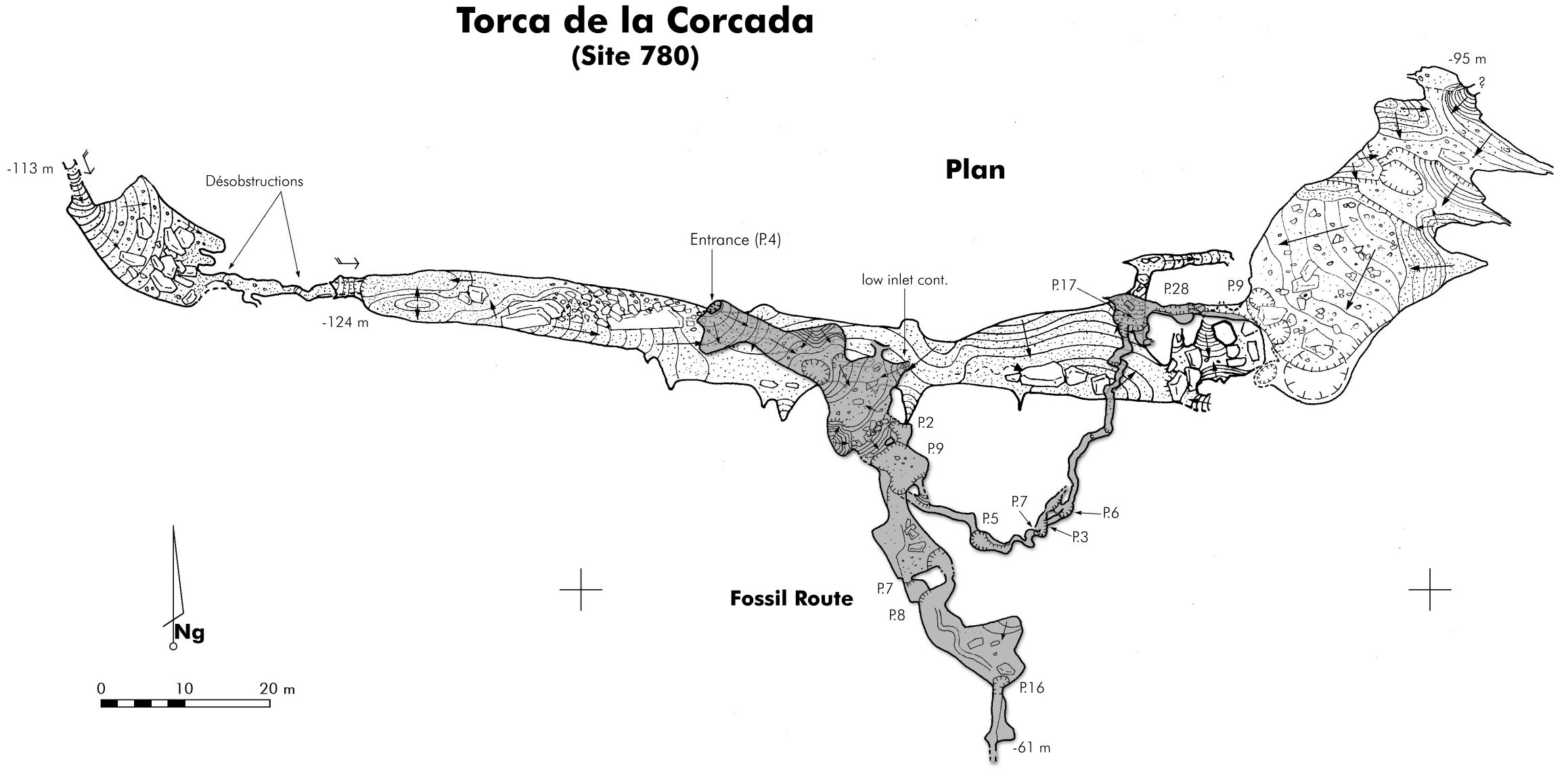
The site has been, at least partly, explored by Catalan cavers and the Active Route was pushed down to a major level by French cavers.
A small entrance in the corner of a field - beyond the newly modernised barn
- which may have to be excavated of an obscuring rock and soil.
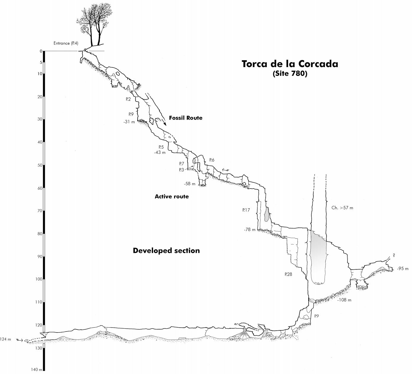
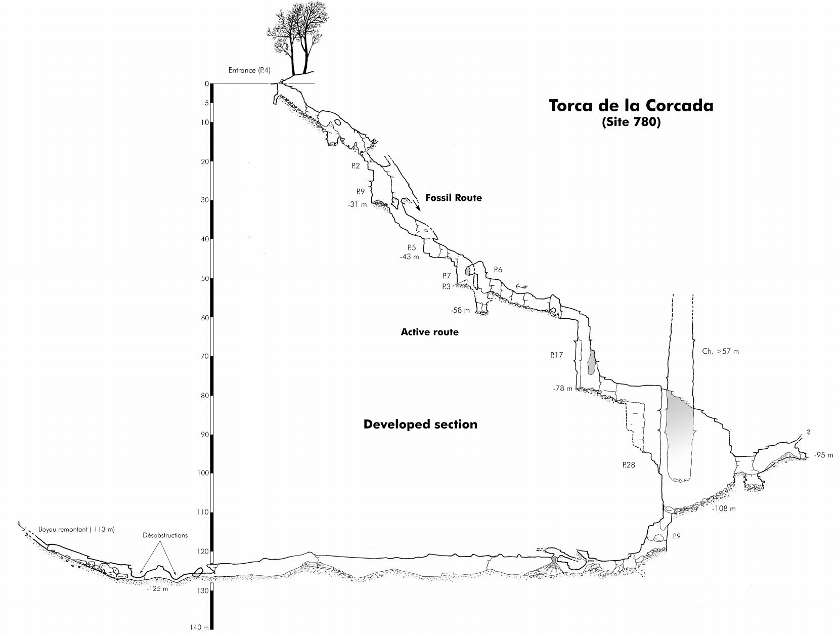
An entrance pitch of 4m drops into a steeply descending passage, littered
with animal bones and roof tiles etc. This ends at a chamber with a small
inlet passage on the left which could perhaps be pushed further.
In the chamber a carbide arrow marks a slot down to a traverse left over
a hole and a 2m climb down to the head of a 9m pitch. At the bottom two routes
go off, an Active Route reached by holes down or a Fossil Route
reached by a 2m climb up on the right.
The Active Route leads to a
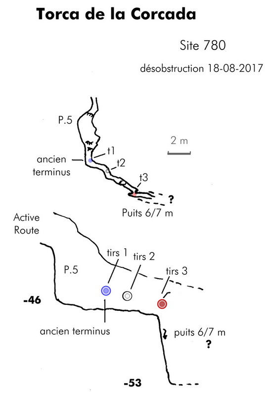
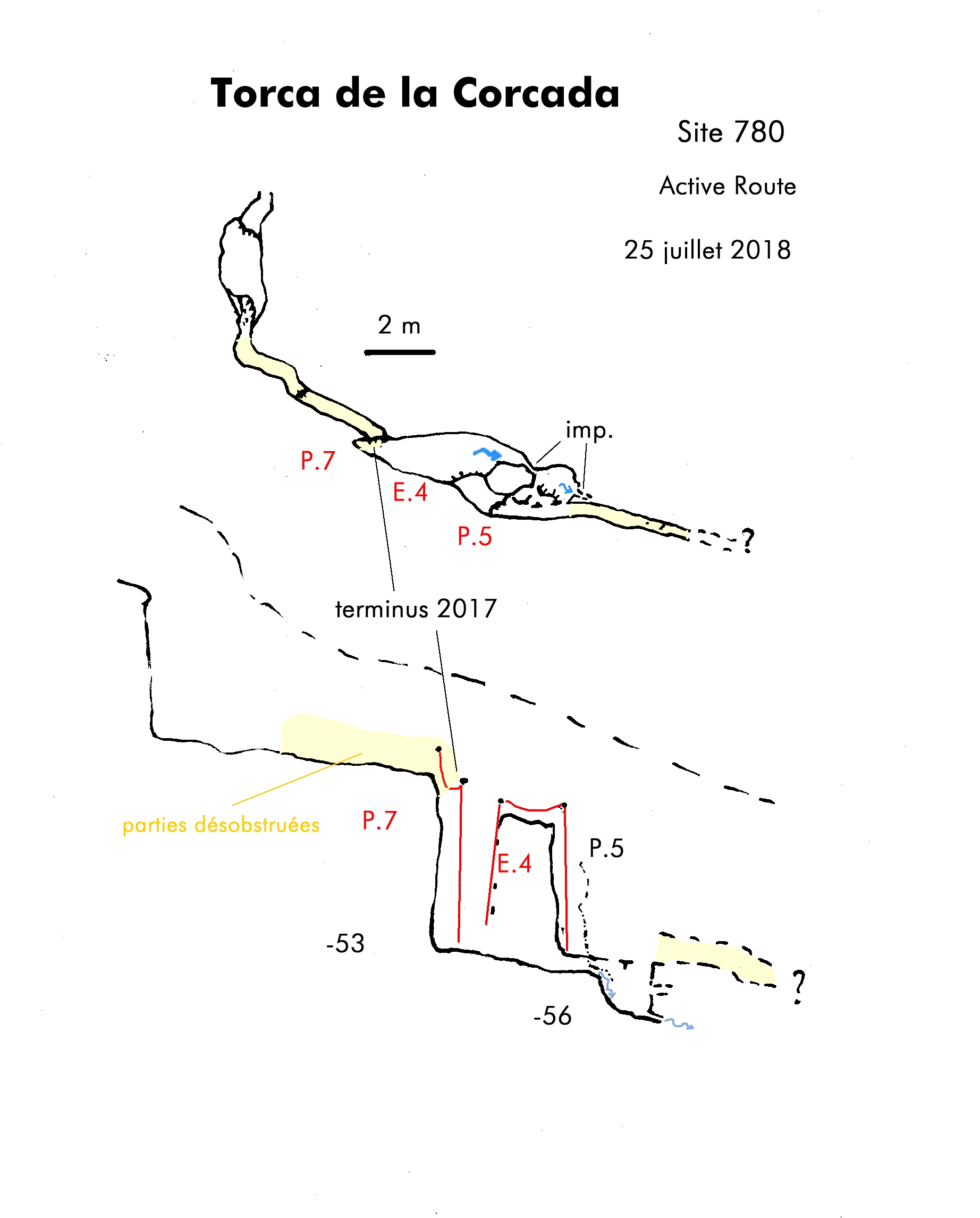
5m pitch in a meander passage, which continues narrow and was enlarged towards the head of another drop in August 2017. (See survey sketch). A single visit in summer 2018 pushed down the p5 in the Active Route and work continued in the autumn, following a narrow meander. (See surveys below). The enlarging of the Active Route continued at Easter 2019 with a breakthrough in the summer, over two trips, when a p18 with a hading rift to a p27, entering a bouldery chamber with a possible drop between the boulders and the wall. (batches 2019-01 and 2019-01). The survey can be seen below.
Further work in the summer 2020, pursued a route between the blocks down a p9 to a walking-size gallery about 100m long. At the end, the route narrows with a draught. See the photos and plan + elevation below.
A later survey (shown as 2020 autumn below) shows Corcada extended to the west by about 30m to a draughting lead. (None of these extensions are yet included in surveyed length)
By the summer, 2021, the work in this series was completed and the surveys can be seen below.
(Complete diary of explorations in the Active Route can be seen here - in French and Google Translated into English.)
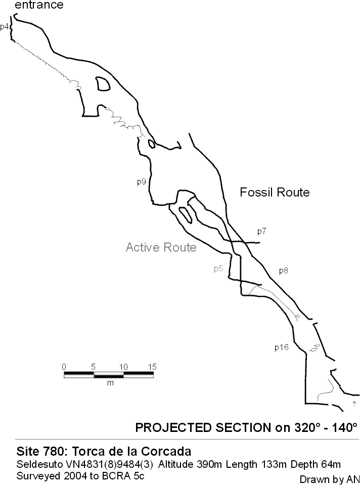
The Fossil Route (rigging topo from 2022 summer logbook) leads to a 7m pitch with a narrow
top, followed immediately by a 8m pitch. At the bottom an aven on the left
has a vocal connection to before the 7m pitch. The way on is to the right,
in a steeply descending bedding (possibly formed like all the cave on a fault
plane) with an abandoned stream trench in the floor. Traversing off to the
left reaches the head of a 16m pitch.
At the foot a short passage leads to a narrow rift which could be pushed. In August 2017 this route was rigged for SRT.
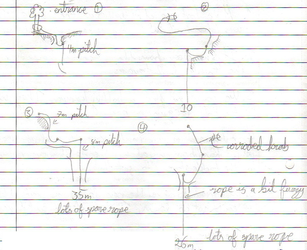
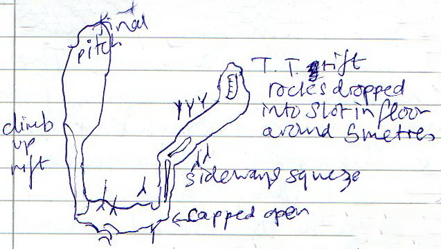
Three trips over Easter 2018 re-rigged the Fossil Route and capped at constrictions near the end. Water could be heard in the distance on day 2. On the final trip: "Squeezed through to a widening grotto. Slots in the floor about 5m deep. Sounds bigger below. Worth continuing capping to gain access." No survey was carried out although a sketch can be seen here.
At the beginning of August 2022, the Fossil Route was opened up to allow a 13.6m survey to tie the end into the base of the pitch (batch 22-01).
A trip at Easter 2007 emerged to say that there were no easy extensions to
be had.
The entrance was found to be strongly draughting in at Easter 2017.
According to the Karsteau site, the last information update by Patrick was 10/11/2023. The length of 600m and depth of 125m has come from that site.
References : pers comm., (P Smith); anon., 2004d (summer logbook); Corrin Juan, 2006; anon., 2007b (Easter logbook); anon., 2014b (Easter logbook); anon., 2017b (Easter logbook); anon., 2017c (summer logbook); anon., 2018b (Easter logbook); anon., 2018c (summer logbook); anon., 2018d (autumn logbook); anon., 2019b (Easter logbook); anon., 2019d (summer logbook); anon., 2020c (Spring, summer logbook); anon., 2020d (autumn logbook); anon., 2021a (January, February logbook); anon., 2021c (summer logbook); anon., 2022c (summer logbook); anon., 2024f (Christmas logbook)
Entrance pictures : summer 2004 : Easter 2019
Underground picture(s): 2004 : Easter 2018 : summer 2020 : 2018 - 2021 Active Route
Video: Enlarging and viewing the Fossil Route, Easter 2018
Detailed Survey : 1:500 plan - gif pdf : Extension in the Active Route, 2017 :
1:500 projected section - gif pdf : Extension in the Fossil Route, Easter 2018 (sketch) : 2018 Active Route Extensions - summer : autumn
after summer 2019 extensions - plan and elevation (Guy & Patrick)
Extension in the Active Route, 2020 - Plan & Elevation (Guy & Patrick) : autumn 2020 - Plan & Elevation
complete surveys 2021 - plan - section
Line Survey :
On area survey : A kml file is available for viewing on Google Earth or QGIS. (Summer 2020) : Latest kml from the Karsteau site (2025)
Visual Topo:: tro file from Guy Simonnot (Jan. 2025)
Survex file : after summer 2019 and summer 2022 (does not include all the Active Route extensions (Amended magnetic declination December 2013 to align with Eur79 grid and coordinates altered to fit ETRS89 datum, April 2014.) : 2021 complete Survex file to come.
Corcarda + Toad + Arenal after summer 2019