Updated 18th April 1999; 14th May 2000; 22nd February 2001; 9th November
2003; 15th April 2008; 4th May 2009; 6th January 2011; 30th June 2018; 12th September 2019; 25th April, 5th June 2020; 9th September, 14th November 2021; 8th September 2022; 7th January 2023; 26th November 2024
The draughting entrance ** is above the resurgence (site 5320) and is a tight downwards
squeeze into a low streamway.
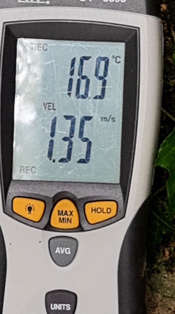
** Anemometer readings, 3rd November 2024, show an outside temperature of 16.9C and air flow velocity of 1.35m/s (pic)
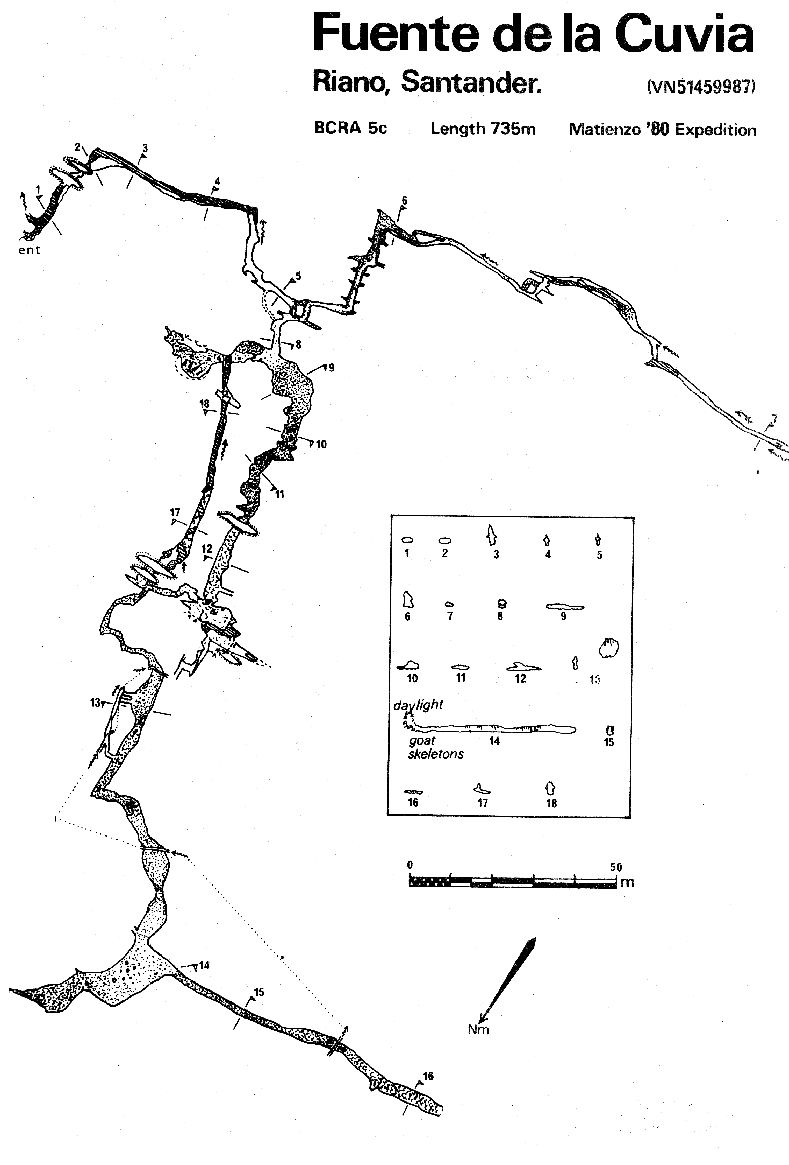
Crawling upstream soon gives way to walking in a small vadose stream passage
and, by keeping to the right, a chamber is reached some 80m from the entrance.
Just back from here on the left, is the passage which carries the draught.
This has been followed in a lowering streamway for about 200m until a calcite
blockage stops progress. This was excavated in the summer 2019 and the mouth of a small passage blowing a strong, very cold draught was snappered. Work continues in this constricted and damp place.
In the summer 2021, further excavations took place with a camera-on-a-stick providing information about what lay ahead. An "armadillo casing" was also used to protect tackle sacs while being pulled along the approach to the dig. This consists of a cut-down digging barrel with thick bungee cords. (Photos of the two constructions below.) The upstream route was also resurveyed and can be seen on the 3d Survex file below, replacing the dotted line and providing a new length of 796m - an increase of 12m.
Two routes are possible out of the main chamber. The right hand passage is
walking and then a low crawl into a chamber; the left hand passage is lower,
wider and contains some fine gour pools. This passage emerges in the roof
of the chamber and it is possible to climb down. A couple of routes from
here eventually combine in a cracked mud floor chamber which leads to 250m
of walking and stooping in a well decorated passage. This ends at a low,
wide bedding which, at Easter 2000, was poked out to the surface near a field
of ostriches. A large flake prevents an exit. The GPS for the Ostrich Farm
"entrance" is ETRS89: 30T 451173 4799728 Altitude 192m, site number
2978.
About 80m back from the end is a well decorated alcove containing a large
number of goat skeletons beneath a blocked-off surface shaft.
The centre line data from 1980 was finally fully entered as an svx file in 2019 and the entrance position GPS'd and adjusted to give the grid reference above.
(Dye dropped into the sink below Fuente de la Cuvia at Easter 2009 was seen in the stream crossing Quadraphenia in Cueva Hoyuca 30 hours later.)
References: Kendal Caving Club and Manchester University Speleological Society, 1975; anon., 1980a (logbook); Corrin J et al, 1981b (survey); Corrin J, 1980 (photo); Mills L D J, 1981; Mills L D J and Waltham A C, 1981 (photo); Corrin J S and Smith P, 1981; material in file; anon., 1999a (Easter logbook); anon., 2000b (Easter logbook); anon., 2008c (Easter logbook); anon., 2019d (summer logbook); anon., 2020b (Easter logbook); anon., 2020c (Spring, summer logbook); anon., 2021c (summer logbook); anon., 2022c (summer logbook); anon., 2022e (Christmas logbook); anon., 2024e (autumn logbook)
Entrance pictures : yes : resurgence : 2019
Underground picture(s): Photos by Frank Addis, 1980 : photos by Juan Corrin : photos by Peter Eagan : photos by Simon Cornhill & Diane Arthurs 2019 : photos by Neil Rumney 2019 : photos by Carlos Lamoile 2020 : Camera-on-a-stick and armadillo casing, summer 2021
Video: Digging at the constricted, draughting upstream end, 2019 (YouTube) : What lies ahead, summer 2021
Detailed Survey : from 1980: low res high res : combined 1980, 2021 survey
Line Survey :
On area survey :
Survex file : 1980 complete (Coordinates altered to fit ETRS89 datum, April 2014.) : summer 2021 (replacement upstream section)
Passage direction rose diagram: 30/8/2018 incomplete data