Updated 8th June 1998; 18th November, 18th December 2007; 3rd January 2008; 11th February 2015; 1st, 10th January, 9th February 2016; 20th May, 12th December 2017; 16th February 2018; 8th January 2020
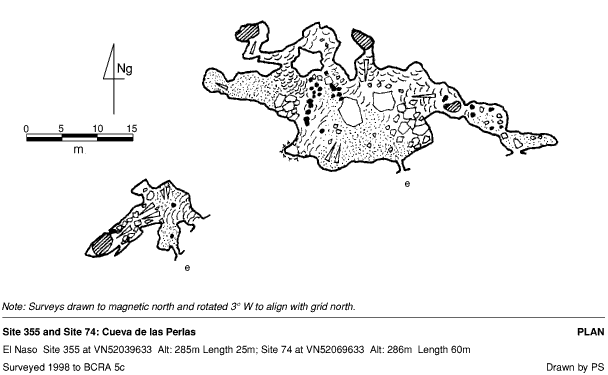
A very pretty cave with easy-to-miss entrances. The western (usual) entrance is a
2m drop (using a handline) down a narrow slot to a floor sloping into the main chamber. The
eastern entrance is larger but quickly lowers to a flat out crawl that joins
the main chamber. The cave is a well decorated fragment with straws, columns,
gours and cave pearls. A section of collapsed sediment has left some stalagmites
at an angle.
Small pieces of pottery have been found on the western entrance slope. One
piece is black and red, with engraved lines.
In February 2015, calcite core samples were taken (with permission) to continue the palaeoclimate investigations in Cueva Asiul. This work is for a PhD by Laura Deeprose at Lancaster University and the British Geological Survey. A BGS blog post outlines the investigations.
Further work was carried out in 2016 and 2017.
From Laura Deeprose: By the end of 2017, after monitoring temperature, CO2 and drip water chemistry for nearly 3 years, the monitoring is revealing some interesting insights into the dynamics of the cave including cave ventilation. The speleothem record work is ongoing but we have successfully found a speleothem covering the period of the Neanderthal extinction at approx. 40,000 years ago. The geochemical record from the speleothem is currently being developed and it is hoped it will provide an indication of how the climate and landscape were changing during the period around the Neanderthal extinction.
At the end of January 2017, the cave was cleared of the paraphenalia used during the study.
Reference Smith P et al, 2015 has a summary of the climate work
(Three attempts to relocate the entrance failed in November 2007,
partly due to digital maps now correctly showing the altitude of the cliff
base. The cave was eventually refound in December then GPSed and
photographed.)
References: Kendal Caving Club and Manchester University Speleological Society, 1975 (survey); Mills L D J and Waltham A C, 1981 (survey); Corrin J S and Smith P, 1981; Manchester University Speleological Society, 1982 (survey); anon., 2007e (autumn + Christmas logbook); anon., 2007e (Christmas + Autumn logbook); anon., 2015jf (January, February logbook); Smith P et al, 2015; anon., 2016a (January, February logbook); pers. comm. 2017; anon., 2018a (January, February logbook)
Entrance pictures : 2007 : 2015
Underground pictures: 2007 : 2015
2016 - formations and paleoclimate work
Easter 2017 - Visit by delegates from the 3rd International Cave Monitoring Workshop
Video: Easter 2010 : wmv (3Mb) : mpg (27Mb)
February 2015 - stal core sampling (YouTube) : 2016 - Palaeoclimate Research (YouTube)
Detailed Survey : 1:500
Line Survey :
On area survey :
Survex file :