Updated 19th February 1999; 28th July 2000; 26th October 2001; 2nd March,
6th October 2002; 6th November 2003; 8th October 2005; 26th September, 28th
October, 17th November 2007 ; 25th September, 19th November, 19th December
2008; 8th May, 23rd October, 18th November 2009; 28th January, 30th September 2010; 6th January, 10th May, 1st October 2011; 23rd April 2012; 22nd January, 20th April, 7th September, 21st November 2013; 14th May, 7th September, 30th November 2014; 14th May, 28th September 2015; 19th May, 30th August 2017; 29th April 2018; 20th September 2018; 11th May, 5th September 2019; 8th January 2020; 2nd September 2021; 3rd May, 4th September 2022; 6th May 2023; 25th April, 18th September 2024; 4th, 18th May 2025
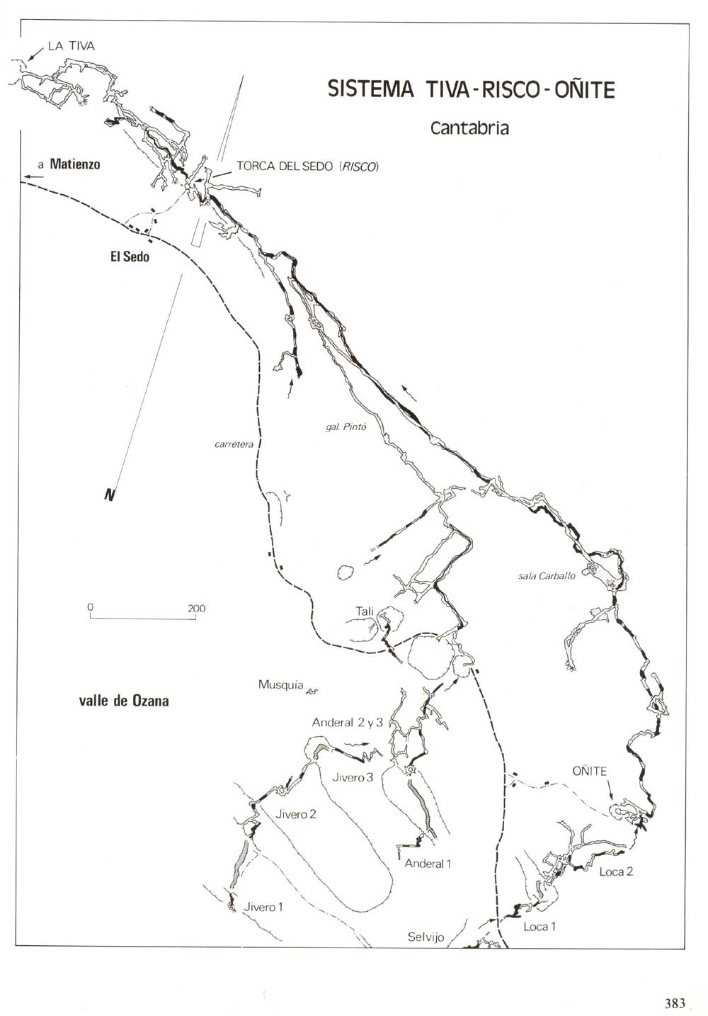
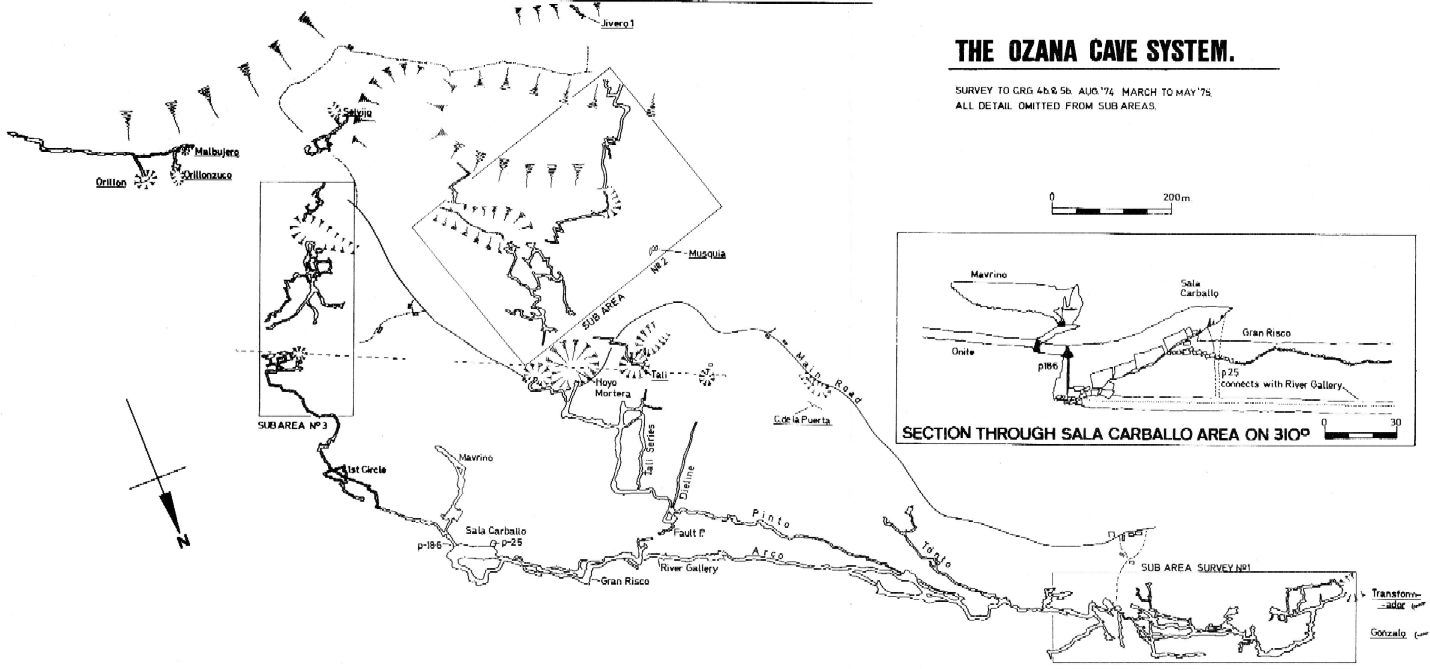
The system has a top entrance at Cueva Oñite (0027) with the through trip down to Sedo (Risco). The downstream continuation to emerge through Cueva Tiva (0026) is currently blocked. At Easter 2025, the inlet Cueva de la Puerta (#0024, length = 785m) was linked in at the Tonto Series.
The usual entrance, Torca del Sedo is situated behind a group of houses
at Sedo. [The tap at the water trough above the entrance has been GPS'd to Eur79: 30T 0453308 4796059 to give an altitude of 193m. This gives the position and altitude of the entrance above. The length above is the combined Risco - Tiva - Oñite in the re-survey.]
A short clamber down leads to the 8m pitch head. The descent can
be damp and the base is strewn with rubbish. Two ways are possible at the
bottom: downstream leads into Cueva de Tiva (026)
- apparently blocked with white goods and domestic rubbish during the summer, 2010 - while a 2m climb in the opposite direction leads into the entrance series
of Risco.
After 100m of large passage the stream is met and wading in 1m deep pools
is needed. To the left are two high level passages both of which choke after
about 100m. In April 2011, a high level passage was entered in this area but choked in both directions over the stream (survey batch 0025-11-01 and DistoX drawing). Straight ahead the streamway continues high and wide to a junction
with a passage on the right. This leads to several dismal chambers and no
way on is possible.
The main streamway continues through deep pools and mud
banks until the Tonto Series is met on the right. It starts as a series of short crawls over mud alternating with larger sections. Gradually it increases in size to a 'hading rift' type of passage up to 10m high on the right. It eventually splits into three: on the left a low passage soon chokes; in the middle a climb ends at the bottom of a rift with boulders; on the right a narrow rift passages slopes up to another obstruction. About 20m before these chokes, a passage on the right comes to the top of a stream passage. This is the water coming from Cueva de la Puerta (0024). Downstream it soon gets very small and is not worth pushing because the water re-emerges later under the right-hand wall in the main stream passage in Risco. Upstream, smaller passage opens into pleasant walking 'keyhole' type streamway. At a pool, a side-passage enters on the left over flowstone. The stream passage continues through some narrow sections for about 40m before breaking out in a chamber where the pitch, and water, enters from Cueva de la Puerta, while another part of the stream comes from a minute sump. [Pete Smith]
The Dambuster Series is reached by climbing across the top of 30m
avens on the south side of the passage just before dropping down to the Pinto Gallery. Five metre diameter, well decorated, parallel passages with deep
holes end at a sandstone breakdown. This was resurveyed, extended and
photographed during summer, 2008.
An alternative climb up into the Dambuster Series (possibly easier) was pioneered at Easter 2022. Named Gracie's Way, the climb has yet to be surveyed.
"The climb is very slippery and exposed, climbing over calcite and on narrow ledges, but quite doable without a rope. The climb/traverse led up into a narrow rift which required some minor digging at the top (mud and small boulders). Once these small boulders were moved, an easy upwards squeeze gained access to the bottom of a pit in the Dambuster Series."
A video of the climb can be found on Andrew Northall's YouTube channel.
The main passage runs for another 100m before reaching the most important
junction in the cave. At this point the right hand, narrow and very wet passage
can be followed up to the superb Pinto Gallery. This vadose passage
contains a large stream and can be followed for almost 2km until it splits
into the various feeder inlets which have their origins in the
Jivero/Tali/Anderal
complex of caves. Although there is much evidence of surface debris,
no surface connection has been made. Archaeological finds made in this area
are described below.
In the summer of 2013, one of these inlet passages, Dieline Passage, was resurveyed and, by removing a boulder, extended southwest to where it becomes too tight with a slight draught. This a few metres below the surface close to a stand of trees in a shallow valley some 90m north of the entrance to Tali 1.
A small p6 was dropped at the end of Tali Series in 2018 to where it needs pushing by a small person in a wet suit.
In the summer 2021, the Tali Series was revisited and the question marks to the northwest (northeast in the logbook?) pushed (marked (3) on the survey). A dig before a tight squeeze entered a drippy 3.5m diameter pitch: 11.5m deep and 7m up, with a rift leading to a tight section. At the base is a promising window at floor level. The pitch has been partly descended (on a rope tied to 2 people). Ladders may be an alternative - see logbook 12/8/21. This was passed (30/7/2022) to find that the "promising window" went nowhere. However, a small, calcited rift did continue, generally heading towards Dyeline Passage. A finakl survey leg (not included in batch 0025-22-01; length 52m) is about 8m long and runs parallel to Dyeline.
This 2021 was marred by the main stream being brown, green, murky and "smelling of shite" with the only clean section being between the beginnings of the Tonto and Pinto series. "What is normally a very enjoyable trip in an active streamway is now somethinbg you try to avoid and is unpleasant."
Back at the main junction it is possible to climb up straight ahead into
a large boulder chamber where 2 routes are possible. The fine Arco
Gallery goes off at high level and is typically 3 - 5m wide and 15m high.
This runs for 400m, around two holes, until it breaks out into the roof of
the Risco River Gallery and progress is halted. (In 1992, on the way back,
two passages on the left were looked at. Chambers at the end were reached
by smashing through stal). In fact the Arco Gallery is the old, abandoned
route and the present stream has cut down to a lower level. This can be joined
from the boulder slope at the start of the Arco Gallery and is easy
going except for the occasional climb over boulder piles.
Where Are All The Spiders?
In the first section of the Arco Gallery a large passage goes off at higher level. This had a few footprints (from first exploration in 1975) when explored in July 2014 but, at a ledge which leads to the edge of a canyon, it is possible to climb down a slot to reached a cracked mud floor - which appeared previously untrodden. A couple of climbs and a traverse over a pit leads to flowstone where the passage becomes very pretty. A squeeze down a slot through the formations leads into a series of well decorated chambers with large broken columns and flowstone cascades coming through slots in the roof. The gaps are completely filled so no way up into higher levels can be found. The entire passage ends at flowstone sealing the passage from floor to ceiling. The series also connects visually down a muddy climb to the main streamway where the survey was tied in to a point just upstream of the Tonto stream junction. Some early photos of this series. Panoramic photo by Paul "Footleg" Fretwell. More photos were taken, for example, at Easter 2023 - see Underground pictures, below.
Where Are All The Spiders? is surveyed as batch 0025-14-01 with a length of 422m. The passage that approaches WAATS from the west (but below) was found choked with calcite when pushed in August 2018. (Batch risco.ramp to 18-03)
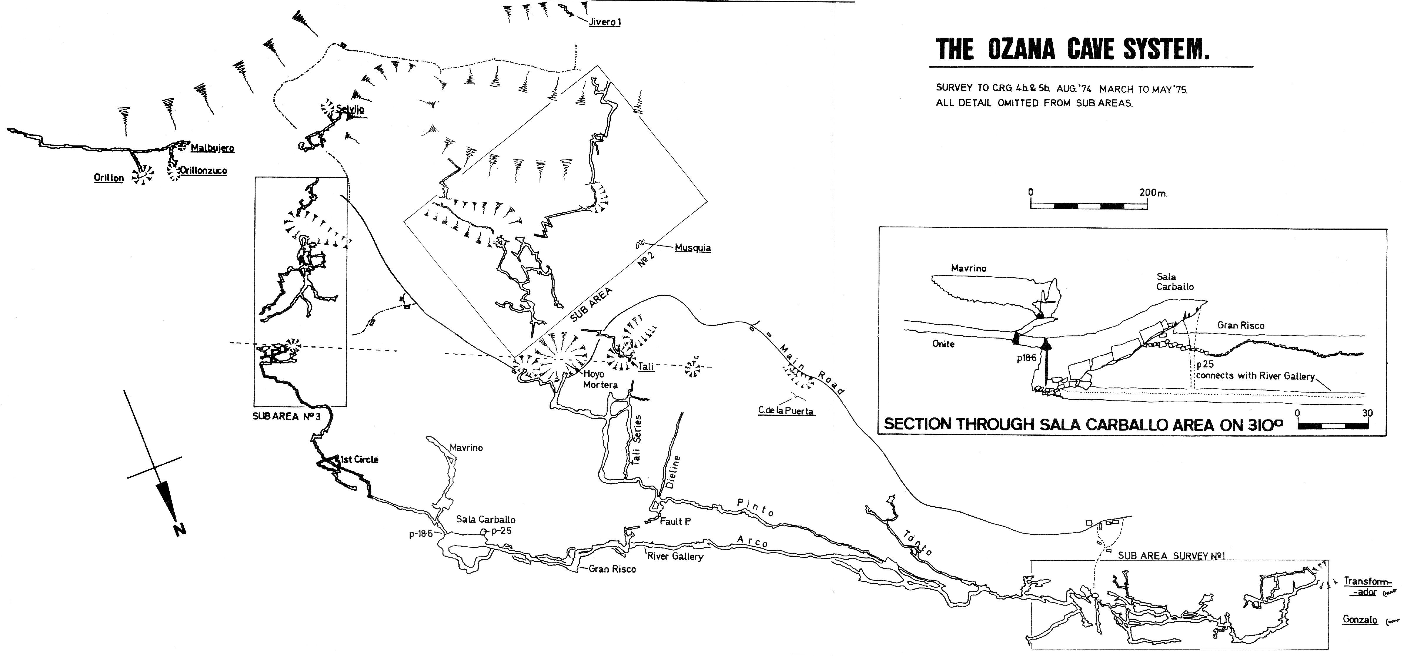
The Risco River Gallery continues for approximately 1km until it emerges
into the impressive Sala Carballo which is a large boulder filled
chamber. The main inlet tumbles down from high up on one wall - this is the
19m pitch in from Cueva Oñite (site 027). This
has been bypassed with a route through from Oñite discovered in
2005.
On the opposite side of the Sala Carballo a large dry passage (Gran
Risco) heads off above the main river and probably originally connected
with the Arco Gallery. After 300m it becomes choked with calcite deposits.
In 1994, the deep hole down to the river at the end of the Arco Gallery
was traversed over. A bolt route leads up to the left after a 4m climb over
boulders. This reaches a dangerous climb up through boulders and a slot up
into a big chamber. Most routes are well decorated with calcite. The upper
gallery goes back across the chamber. A side passage up a 15m climb leads
to Disney World with amazing formations including a triangular mono
crystal stalagmite about 1m high. (A photocopy of a section from Cave
Minerals of the World is in the Risco file). The route continues as the
high level Arco 2. Solid roof is seen with no indication of any inlets
from Muela / Mullir. Some 300m along it is possible to abseil down into the
main Arco Gallery (photos) and
this is the safest way up to the extensions. Arco 2 ends at a traverse with
no ledges where bolting is required.
At Easter 2024, a new, safer bolt route and free hanging pitch was installed to reach the Upper Arco Gallery. (The climb goes up close to "Shaft from Arco to Stream Passage" on the survey.)
In summer 2010, attempts were made to reach the middle level where it is "missing" half way along the cave. One climb of 8m led to an area of shale and loose rock with no place to fix bolts. The second climb was found 50m to the north with an easy route up to a loose area. Rope was fixed to two good bolts at a Y-hang. Probably 6 more bolts are required but the problem will be finding rock to fix into. "Big passage" can be seen above. Another attempt was made at Easter 2011.
In the summer 2011, a climb into a possible Arco continuation failed due to poor rock. However, a climb near to Risco entrance succeeded in entering 102m of good size passage above the stream.
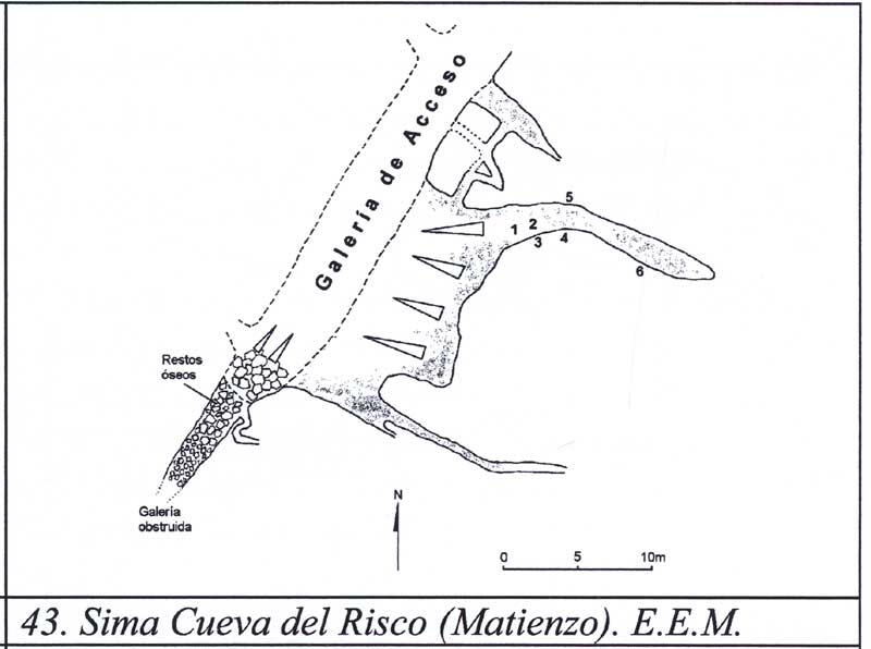
Archaeological remains have been discovered. The S.E.S.S. found remains of
a large deer, possibly Cervus megaceros. In 1975, in the same area
(the end of the Pinto Gallery), L. Mills discovered a
palaeolithic bone spearhead also
described as a mono-bevelled bone assegai, 8.5cm in length and with a circular
cross-section, possibly Magdalenian. More recently, the possibility
of more remains and small engravings has been published.
Photographs of engravings on the walls
can be seen here. (See also Ruiz Cobo Jesús and Smith Peter et
al, 2001). Smith Peter, 2006 concludes that there are 2 figures
of ibex and that the assemblage can be dated to the early-middle Magdelenian,
although Ruiz Cobo Jesús et al, 2008, p96 suggests that the
engraving is similar to that in Cueva del Otero. A survey fragment (from
Ruiz Cobo Jesús et al, 2008) appears
here.
Ortiz in Algunos crustaceous y miriapodas cavernicolas de la Region de
Matienzo, Santander (Ortiz E, 1968) describes 18 individuals of Gammarus
berilloni Catta.
A dye test in 1964 showed water from Sima-Cueva del Risco resurging after
five hours from La Lisa below Cueva de Gonzales (014),
Cueva de Transformador (032) and in
Cueva de Tiva (026).
About half way along the through-trip, in the big old fossil passages, there is a bank of sediment about 4m high with well differentiated strata ranging from silt to cobbles. (Photos: December 2012). Curly Mud Passage starts below this sediment wall. It was surveyed to a length of 180m at Easter 2013 with the passage varying in size, up to 4 or 5m wide and 2 - 3m high. The route connects with the stream passage upstream, in the roof of the high meander passage. There are not many stal but there are curly cracked mud floors.
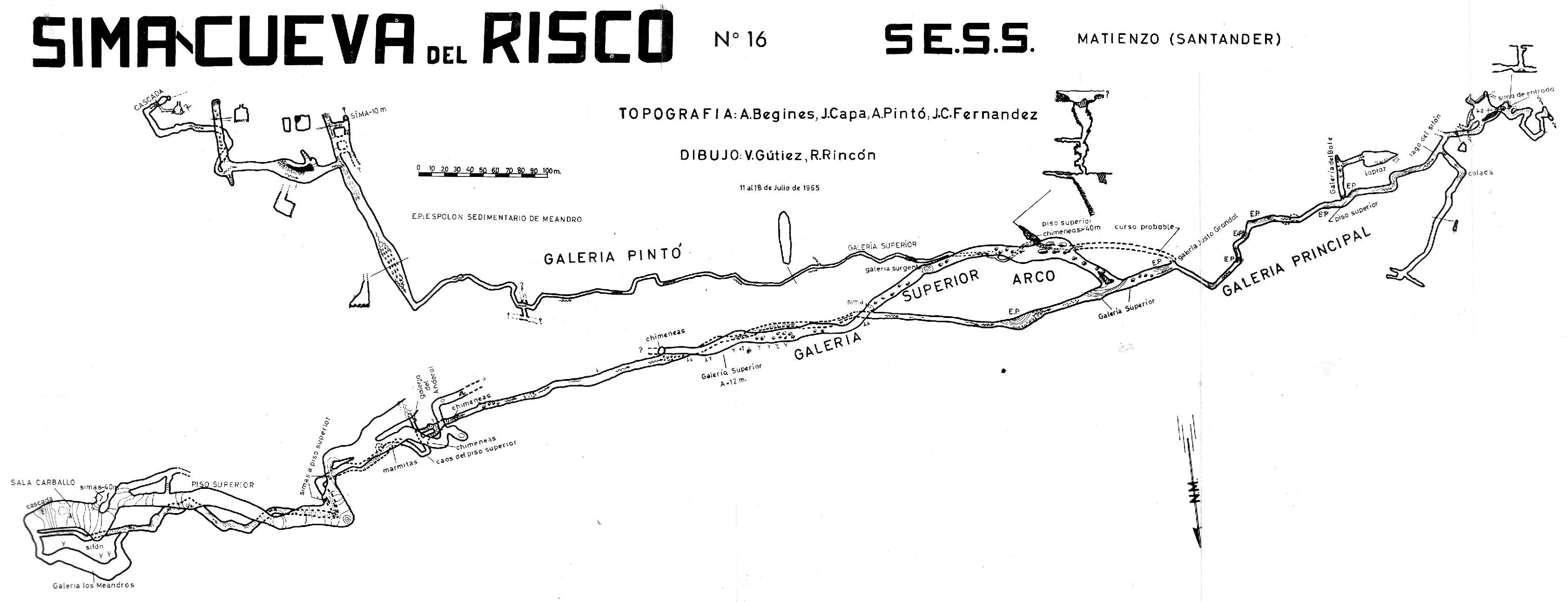
The cave has been resurveyed, coordinated by Pete Smith. In November, 2009, 250m was surveyed with some "new" passage where oxbows were surveyed. The latest version of the survey was completed after Easter, 2022.
Spider and bug collecting was carried out during the Easter 2014 expedition and several specimens were collected in July of a possible new species identified from Easter. This small spider spins a horizontal web and appears to prefer small alcoves. In Risco, this species has been spotted along the streamway from around the Galería del Bote onwards upstream as far as the Arco Gallery entrance mud slope. In July 2014, around 30 individuals were counted with about 10 clustered around the Tonto stream junction. (The Galería del Bote was surveyed in August 2018; batch 18-02)
Over Easter 2018, the Matienzo Karst Entomology Project
(led by Tom Thompson) followed up previous work by collecting bugs, spot sampling and setting pitfall traps in a number
of sites under a Cantabria-wide permit. The Entomology Project carried out some work in this cave and made a visit to Where Are All the Spiders? Traps were retrieved and spot sampling was carried out over Easter 2019. Photos were also taken.
The European crayfish Austropotamobius pallipes was also spotted (for the first time?) in the stream in July 2014.
According to the Diario Montañés, 28/8/2017, there is a possibility - after a government study - that the cave may be closed to cavers to protect the engravings.
Summer 2022: Various additions
These can be viewed on an annotated survey by Andrew Northall.
References: Fernández Gutiérrez Juan Carlos, 1965; Fernández Gutiérrez et al, 1966 (survey and photo); anon., 1974b (logbook); anon., 1974a (survey); Cox G, 1973; Fernández Gutiérrez J C, 1975; anon., 1975b (Easter and summer logbooks); Kendal Caving Club and Manchester University Speleological Society, 1975 (survey and photo); anon., 1977b (logbook); anon., 1978 (logbook); Manchester University Speleological Society, 1982 (survey and photo); Mills L D J, 1981; Mills L D J and Waltham A C, 1981 (survey); Mills L D J and Waltham A C, 1981 (survey and photo); Smith P, 1981a; Corrin J S and Smith P, 1981; anon., 1981a (logbook); anon., 1982 (logbook); Meijide Calvo M, 1982; Corrin J, 1983c (photo); anon., 1986 (logbook); Garcia J L, 1987; material in file; Ortiz E, 1968; Fernández V, 1988; Muñoz E, 1988; anon., 1992b (logbook); Cawthorne B, 1992; Corrin J, 1992b (survey); anon., 1993b (logbook); Muñoz E and Bermejo A, 1987; anon., 1994b (logbook); Corrin J, 1994b (survey); Fernández Ortega F, Valls Uriol and Maria del Carmen, 1998; García José León, 1997 (survey and photo); Corrin Juan, 1997c; Smith Peter and Ruiz Cobo Jesús, 1999; anon., 1999c (logbook); Corrin Juan, 2001a; Ruiz Cobo Jesús and Smith Peter et al, 2001 (includes drawing); anon., 2002b (summer logbook); Corrin Juan, 2003b; Ruiz Cobo Jesús and Smith Peter, 2003; anon., 2005b (Easter & summer); Corrin Juan, 2006a; anon., 2006d (summer logbook); Smith Peter, 2006; anon., 2007d (summer logbook); Corrin Juan and Smith Peter, 2007; Corrin Juan, 2007a; anon., 2008e (summer logbook); Corrin Juan, 2009; Ruiz Cobo Jesús et al, 2008 (survey) ;anon., 2009d (autumn logbook); anon., 2010c (summer logbook); León García José, 2010 (Volume 1 and Volume 2) (survey and photos); Corrin Juan, 2011; anon., 2011b (Easter logbook); anon., 2012f (Christmas logbook); anon., 2013b (Easter logbook); anon., 2013d (summer logbook); anon., 2014b (Easter logbook); anon., 2014c (summer logbook); Papard Philip, Corrin Juan and Smith Peter, 2014; anon., 2015b (Easter logbook); anon., 2017b (Easter logbook); anon., 2017c (summer logbook); anon., 2018b (Easter logbook); anon., 2018c (summer logbook); anon., 2019b (Easter logbook); anon., 2019d (summer logbook); anon., 2019e (autumn logbook); anon., 2021c (summer logbook); anon., 2022b (Easter logbook); anon., 2022c (summer logbook); anon., 2023b (Easter logbook); anon., 2024b (Easter logbook); anon., 2024d (summer logbook); anon., 2025a (Easter logbook)
Entrance pictures : yes : Easter 2025
Underground picture(s):
photos from Easter 2025, Where Are All the Spiders? (Paul Fairman)
photos from Upper Arco, Disneyland, summer 2024, Sam Davis
photos from Where Are All the Spiders?, Easter 2023 - Andy & Mindy Filer : Paul Fairman : Sam Davis
photos from Easter 2022 (Andrew Northall)
photos from Easter 2019 (Amata Hinkle and Jason Kirby) : photos from summer 2019. fire salamander (Patrick Warren) : photos from autumn 2019, crystals
photo from Easter 2018 in "Where Are All the Spiders" (Amata Hinkle)
photos from Easter 2017 (Alex Ritchie and John Gunn)
photos from Easter 2015 (Alex Ritchie)
photos from summer 2014 (Nigel Dibben, Paul Dold and Paul Fretwell) : Panoramic photo of the crystal pool chamber by Paul Fretwell
photos from Easter 2013 (Paul Fretwell, Tom Thomson and Peter Smith)
photos from December 2012 (Simon Cornhill & Peter Smith) : photos from Easter 2011 (Phil Papard)
photos from summer 2010 (Paul Dold) : photos from summer 2009 (Steve Martin)
photos from summer 2008 in the Dambuster Series : photos from summer 2007 in the main galleries
near the end of the Pinto Gallery : Scanned slides from 1977, 1978 (Frank Addis)
Videos : El Sedo entrance into Upper Arco (2014) (YouTube): Where Are All The Spiders extension (2014) (YouTube)
Gracie's Way, climb up into Dambusters' 2022 (YouTube) : Washing off in the Risco Stream - Easter 2023 (YouTube)
Detailed Survey : from 1965: low res high res Oñite survey updated 2005
from rescue site (Risco, Tiva and Oñite) low res high res
survey fragment of the archaeology finds (Ruiz Cobo Jesús et al, 2008)
survey fragment: batch 0025-11-01 high level extension just upstream of entrance, DistoX plan file
2009 survey of Risco and Oñite (Peter Smith) : 2013 Easter survey of Risco and Oñite (Peter Smith) : 2013 summer survey of the Risco - Oñite System (Peter Smith)
survey fragment: batch 0025-14-01, Where Are All The Spiders?, DistoX plan file
2014 summer survey of the Risco - Oñite System (Peter Smith)
2018 summer survey (Peter Smith) : 2022 Easter survey (Peter Smith) : 2022 summer survey (Peter Smith) : Survey additional notes (Andrew Northall)
Line Survey :
On area survey : 1975 Ozana area map. Not a lot of detail. low res high res
Survex file : yes, with Oñite, Puerta and Tiva (latest after Easter 2025) : caves in Ozana area (after Easter 2025)
Passage direction rose diagram (Patrick Warren): yes, with Oñite and Tiva