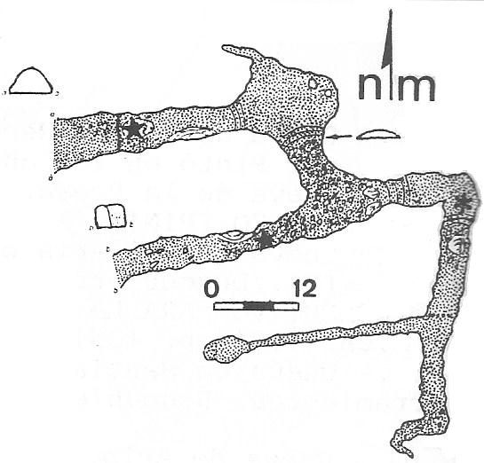
A walk-in entrance (at the northwest of the cave) passes under a small shaft to the surface and, after 20m, reaches a steep calcite slope down into an impressive chamber, about 10m high. There is a possible passage seen high up on the east wall and also closer on the north wall. At floor level, a hole drops into a small chamber with a tight slot. A crawl to the north closes in.
The main way out of the chamber is a walk up into a crawl that soon connects with another parallel passage. To the right, a walk up a slope emerges on the surface at the second entrance. Just back from here, a crawl on the north side ends at a window onto the first entrance passage. To the left, a short climb over boulders meets a turn to the south. After 15m of crawling, a junction is met. Further crawling ahead enters an increasingly well decorated (and constricted) area with the current end being a very low continuation that would require much digging. Back at the junction, a rift passage has easy climbs which enter a chamber with tall columns.
Beyond is a small hole to an enlargement which may have been passed by others. The route was enlarged at Easter 2016 when it was discovered that the floor was false and, after a hole had been knocked through, that there was a metre drop to a solid floor. The route over the top was enlarged enough to allow one of the team through into a wider and lower passage, with plenty of stal. After 15m it reaches a surface run-in with roots and a drippy aven. The extension was surveyed (L=18m) and photographed in August 2016.
Reference: Ruiz Cobo J and Muñoz Fernández E, 2013; anon., 2015a (January, February logbook); anon., 2015b (Easter logbook); anon., 2016b (Easter logbook); anon., 2016c (summer logbook)
Entrance pictures :
Underground pictures : 2015 and 2016
Video : Exploration and survey, May 2015 (YouTube) : constriction to southern entrance, Easter 2016 (YouTube): enlarging constriction, Easter 2016 (YouTube)
Detailed survey : scan (GEIS) : resurvey May 2015 : complete survey, August 2016
Line Survey :
On area survey :
Survex file : yes