Updated 1st May, 28th September, 29th November 2012; 30th April, 8th October 2013; 25th May 2014; 5th January 2015; 18th April 2016; 23rd January 2018
The sandy crawl fills up with water and sand and silt, taking 3 days to re-excavate in the summer 2012. The cave should not be entered if rain is forecast. The entrance crawl was found to be silted up and sumped and no draught detected in November 2012. In the summer 2013, the underground dam was found destroyed and there was some digging to clear the entrance crawl blockage.
The crawl was re-excavated of sand and boulders before pushing could start at Easter 2014.
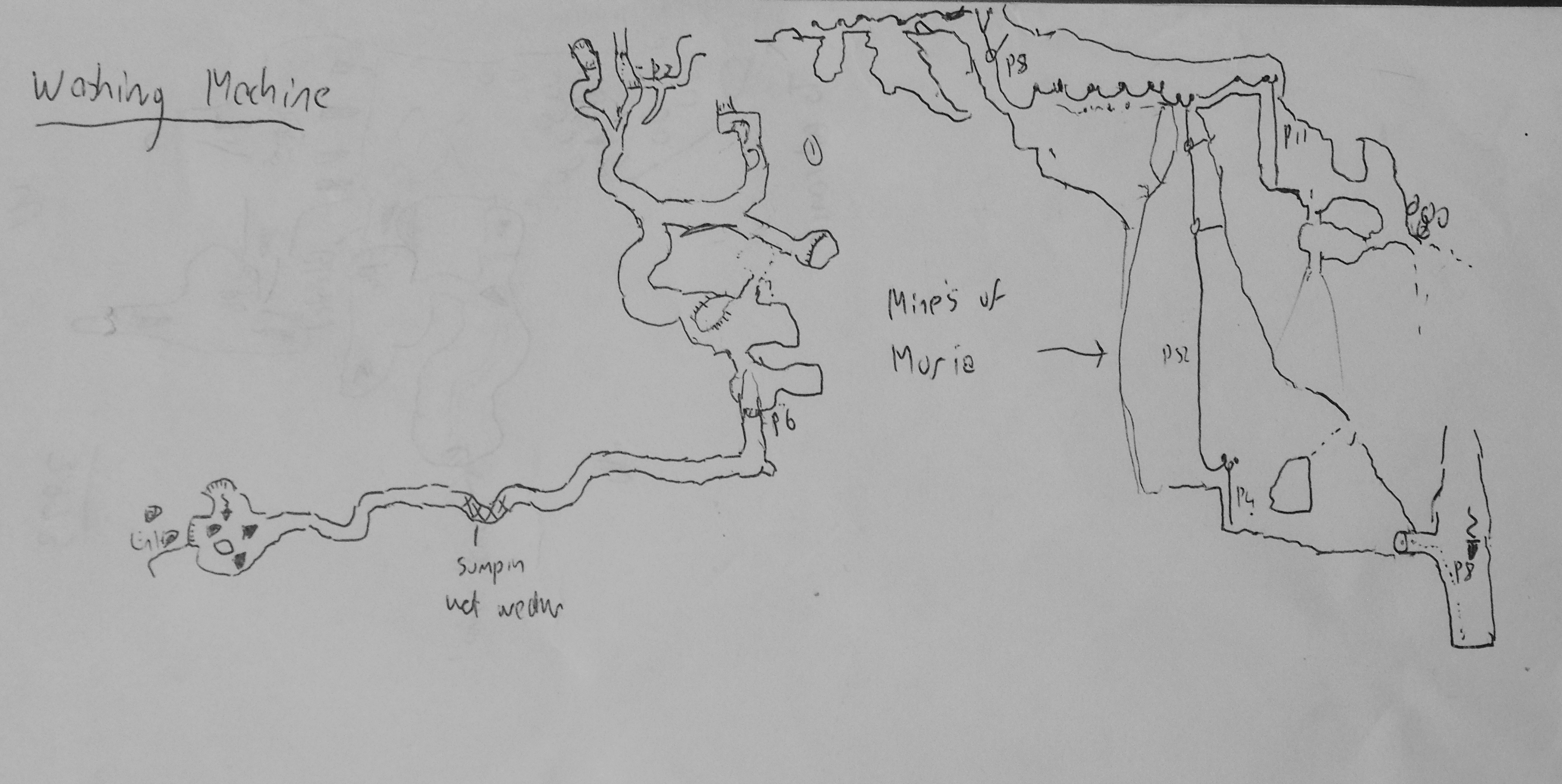
The large cave entrance is at the bottom of a long, wooded gulley. A climb down 4m onto farm rubbish enters a descending passage past a washing machine and narrowing rift passage. A flat out, slightly draughting crawl at the end has been excavated to reveal "another 170ft of passage down a 18ft pitch. "Mainly walking size passage ending in blind holes in the floor".
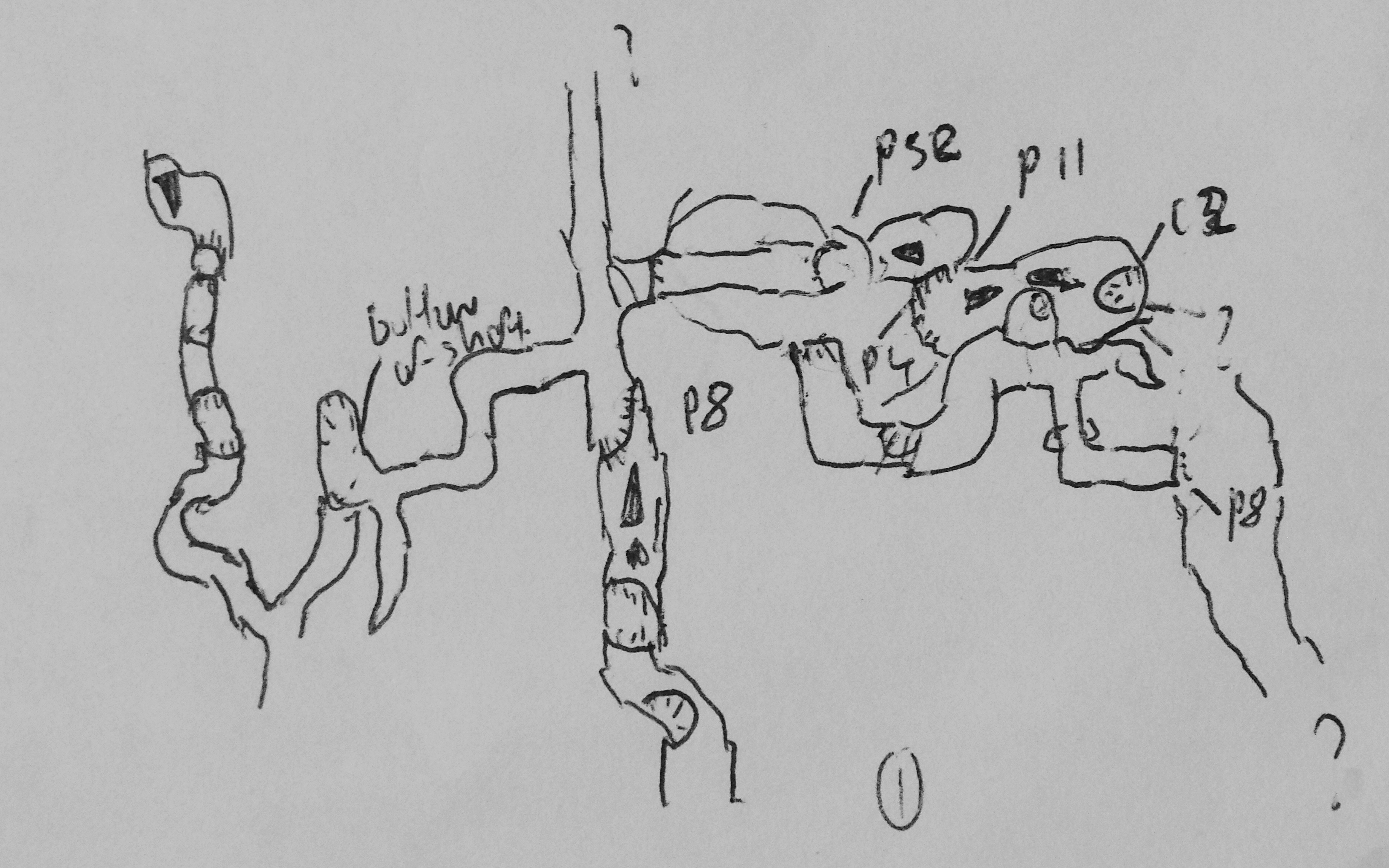
A passage on the south side of the cave is comfortable walking with a mass of helictites on the left wall and leads to a number of holes in a calcited floor requiring care to pass overhangs. A traverse line has been installed on the second hole which has been descended for 12 - 13m but may continue at the draughting base. Beyond further walking passage, a third hole has an estimated 50m depth (see below). On the traverse line out to pit 3 a "number of bolts did not tighten as expected probably due to the soft rock."
A continuation of the traverse over the p48 (Easter 2014) leads to an 11m pitch into a well decorated area with no way on.
At Easter 2013, several days digging out of the entrance allowed exploration down the p48. A smaller p4 followed then 15m of horizontal passage to a much smaller way on. Flood debris was found 4 - 5m above the floor at this point.
The very tight passage at the lowest point in the cave was pushed in April 2014 to an 8m pitch which was passed in November 2014. A tight route and pool meant drilling was not possible and natural belays were used and a feet-first approach to the head of the pitch. At the base, after a 30m aven, there is a short length of large passage. To the left, a rock bridge has a jaw bone and the route continues down a series of small climbs to end at a U-shaped, tight crawl that appears to continue.
In November 2014, an undescended p16 at the end of one of the upper level side passages was dropped. After 15m of rift passage the route enters the main pitch about 5m below the traverse to the pitch head.
In November 2015, the cave was found to be "not passable" but was draughting out.
(Two holes 7m above the entrance, on a ledge, have been documented as site 3779.)
Reference: anon., 2011e (autumn logbook); anon., 2012b (Easter logbook); anon., 2012d (summer logbook); Corrin Juan, 2013a; anon., 2013b (Easter logbook); anon., 2013d (summer logbook); anon., 2014b (Easter logbook); anon., 2014d (autumn logbook); anon., 2016b (Easter logbook) (November 2015 logbook account pasted here)
Entrance pictures: yes
Underground pictures : 2011 : 2012 : Easter 2013 : Easter 2014 : autumn 2014
Video :
Detailed Survey : sketch : sketches from Alex Ritchie plan & elevation plan (Does not include the end section of the initial exploration high level passage that ends with three pits and a sand blockage.)
Line Survey :
On area survey :
Survex file : yes (Amended magnetic declination December 2013 to align with Eur79 grid and coordinates altered to fit ETRS89 datum, April 2014.)