Updated 19th July, 1st November 2010; 6th January, 24th, 27th May, 16th October 2011; 15th January 2012; 7th, 8th October 2013; 24th, 25th May 2014; 1st July 2018; 30th November 2023
Major extensions were made in November over 7 trips providing a total of 845m. The account below will eventually contain a description of these extensions.
The entrance is a small, outward draughting hole in a small depression about 4m from the road. A slide down a mud slope goes under two boulders and drops into a fluted, limestone hollow. A climb up the opposite side reaches the 30m pitch head. Two bolts on the right (backed up by a large outcrop, also on the right) allows an awkward, feet first, flat out approach to the pitch head. (Note: a rope protector is needed to avoid the inevitable rub.) A steeply sloping pitch starts over calcited features - many have been removed to make the drop safer. A deviation after 6m avoids the majority of the rub. The pitch was heavily decorated with (loose) calcite, now much removed and / or rather grotty, again making the pitch safer. The initial landing is on boulders wedged in the rift then a tighter, gnarly, final 6m to the bottom.
The way on is via the lower but wider sand-floored passage to a right turn at a T-junction. A squeeze around stal columns leads to further stal columns which can be bypassed on the left. A blind hole in the floor is crossed over then obvious passage is followed, watching out for the loose walls which tend to collapse rather too easily. Side passages are mainly dead ends. At one point a pile of fallen slabs marks the position of the Bridge of Doom - a roof collapse feature, now destroyed. (See photos below).
Shortly after this, a passage goes off on the right. This leads to fragile rift passage and the way on to the lower series via a ladder pitch at the start of the rift. (A 10m ladder is required with a long belay to a boulder at the start of the passage - although two 10m ladders work well.)
Back in the main passage the route leads past two sets of "pretties" (care!) to gradually descending passage to a drop of 2m (on the right on stals) into the final section. Immediately after the drop there is an aven on the right that appears free climbable but is awkward. This has not been climbed yet but a way on can be seen. Further on is an excavated hole in the floor which is a climb down 2m to a constricted rift with pretties and a possible pitch down to the Sump Series seen ahead. Back on the main level, the way on is straight ahead to a sandy aven. To the left is a sand choke with a possible easy dig to continuations. Ahead is a sandstone boulder choke. To the right is small, crawling passage to an approximately 7m pitch with a puddle at the bottom. (This is believed to connect to lower Sump Series, but not proven as yet.)
It's Not Big and It's Not Clever is a low, crawly, horrible
dead-end on the right near the end of the higher level, dry series.
Back at the the turn off to the lower Sump Series and the ladder pitch down, the water can be followed through hands and knees / walking passage for approximately 300m. Several oxbows have been noted and one significant inlet on the right (Orange River). At around this point numerous eels have been seen. The passage continues downstream to a wider area with minimal airspace which sumped off after slight rain. This was dived in the summer 2013 by Tim Webber. At 14m in, a cross rift is met with sandstone boulders and a possible way on. The dive line at this point has "Encaramada" written on it. The sump is very tight at the start: the returning diver was stuck for 5 minutes until he removed his cylinder and helmet. This point must be very close to Cave of the Wild Mare.
At the foot of the ladder to the lower Sump Series, upstream ends at a calcite blockage but with "bigness" apparent beyond. The way on is to the right via thrutching passage to a chamber which has a hole in the roof. This has been disto'd to 23m. The way on is on the left of the chamber followed by a right turn. Going upstream, a climb over a stal curtain passes various avens and inlets. (At the top of the climb a passage to the left veers right for 5m and has sign and sounds of "bigness" ahead. This was not entered due to lack of time). A notable climb up on the left enters a boulder-filled chamber leading to a sump and boulder-filled aven (I Want Me Mum Chamber). The upstream continuation - at various levels according to girth - is in sharp and very gnarly passage. This is where the Easter 2010 survey ended with a small inlet on the left leading to a small, low passage with a sump. The way on is now dry with an inlet on the left leading to a "reasonable" 5m climb up to dry sand / mud phreatic passage (not entered). Back in main passage the way on trends left and slightly uphill with the way on continuing lower and wider. No draught was evident at the time or the "grab-fest" would have continued.
The cave was extended by 2373m in the summer, 2010. The bulk of the following passage description from summer 2010 is by Dickon Morris.
Above the upstream sump in the lower streamway is a 5m climb, Stairway to Heaven. A short crawl at the top pops out into walking size passage. To the left is about 20m of passage terminating at a choke where a cattle tooth was found - El Torro choke. Going right from the top of the climb the passage continues fairly pleasantly.
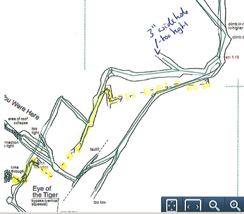
After 50m a junction is reached. A ramp to the left leads to about 100m of passage - Wish You Were Here - terminating in a stal choke. Above the passage just before the ramp a passage in the roof can be followed to a small, blind pot with a passage on the other side - this is unpushed.
Just before the pot, a passage to the left leads via an extremely tight squeeze to a large rift which is unpushed. The right hand passage is pleasant for 100m and reconnects at the El Torro choke.
Continuing on from the bottom of the ramp, the passage becomes too tight after about 30m directly after some impressive stal. The way on is an obvious step up to the right where a squeeze with a strong draught is reached after 30m. Twenty metres after the sqeeze the passage becomes very narrow but there is an obvious step up to the right. After 60m of crawling and stooping, the passage pops out in a large stream canyon.
To the right, the canyon immediately becomes low but continues for over 100m to a too tight squeeze. Worming through boulders to the right leads back to the far side of the stal squeeze.
At Easter 2014, at the southern end of the Boulevard of Broken Dreams and opposite the entrance to the passage leading to Tin Man Junction, a short series of passages were entered. These are apparently previously entered but the survey included a nice grotto which didn't seem to have been previously visited. (Batch 3380-14-02. Length 97m).
On the same trip, some digging was carried out just after the pitch into This Way and That - the offset on the survey. A sandy crawl breaks into a larger continuation but access is prevented by boulders. A wreaking bar would probably allow entry, but the air seems stale.
I Want It All area
Going left down the stream canyon leads after 10m to a concealed junction with a major side series (Wizard of Oz Series) to the left. Twenty five metres later a choke is reached and worming easily through this enters the most pleasant passage in the cave (Long Road To Ruin) which is a 300m stomp to a boulder choke.
Just before I Want It All, a passage on the right (labelled "open" on an earlier survey) was entered and surveyed as "3 oxbows back to the main passage" at Easter 2014. This batch 3380-14-01-Oxbows, length 59m).
Passing this choke (I Want It All) involves a tight and awkward squeeze which pops out into a very large chamber with high avens. By climbing to the top of the boulders it is possible to find two high level ways on. The first is reached by a (slightly) bold step. A walk up a narrow ramp leads to about 70m of varied passage. At one point there is a step over a deep rift but traversing along this rift reaches a window to the right with an undescended pitch.
Back in the large chamber a passage can be seen on the wall to the right of the previously described passage. It will require a bolted traverse to reach this good lead.
At the base of the large chamber are a few passages going off.
The area was revisited at Easter 2014 and the following observations made. There is a very strong draught through the initial squeeze into the large chamber, much stronger than that coming from the entrance to Map of the Problematique. Up in the boulder pile above the squeeze, in the side passages surveyed on the origianl survey, the final leg with no passage detail leads to a complete choke. The undescended pitch is about 10m, in a rift, and not obviously draughting. It's hard to say if there is passage below. There are possibilities of a few high level leads but they may just be blind alcoves.
The way on south is a draughting crawl just inside the entrance to one of the small passages. This leads to a maze-like area (Map of the Problematique) where only a single route through has been pushed. There are lots of leads here. This reaches a second large chamber after 200m which has only been briefly looked at on a single visit. It appears to have lots of leads.
At Easter 2011, the route at the south end was pushed through over 2 trips to a chamber with all leads closing down. The chamber was about 80m horizontally away to the northeast and about 50m down from the sink, site 3170, at the base of the giant Hondo depression. Fuller descriptions for batches 3380-11-01 and 3380-11-02 will appear here.
Wizard of Oz Series From the junction with the canyon is about 80m of mostly crawling passage to a junction with a walking size passage (Tin Man Junction). To the left soon reaches another junction where the left hand passage is very pleasant for around 60m passing some 1.5m long straws before it reaches a section with some good, dry gour pools and becomes completely choked with flowstone. By entering a rift to the left as you reach the final section of passage it is possible to climb down and pass through a squeeze. This pops out in the roof above the step after the stal squeeze earlier in the cave and provides a useful shortcut.
To the right at Tin Man Junction is 60m of narrow but reasonably high passage to a chamber with a cairn and two ways on. The left hand way is a yellow-floored passage (Yellow Brick Road) which goes for about 80m to a boulder choked aven. Straight on at the junction leads, after a crawl and a squeeze, to a sandstone boulder choke. This has been passed by the author to reach a walking size passage with a good draught and heading in the "right direction". However, the choke began to fall on the return so stabilising is required.
At Easter 2011, this was passed and the area described thus: From the corner before the Dickon Trap (heading towards the end) left leads 5m to boulders. Right leads through a crawl to a small chamber followed by a further crawl to a small sandstone choke. A duck under a boulder and a hole in the floor and a crawl to the Dickon Trap. A climb over boulders leads to a small aven where the passage descends to a small muddy / snady meandering rift passage which can be followed for 40m through a couple of constrictions. Straight on up the slope leads to a calcite blockage. A climb up the rift back on yourself leads to a 15m aven blocked at the top with boulders. There are no leads to push. The Dickon Trap Extension is surveyed as batch 3380-11-02.
The upstream sump in the lower streamway was found to be open in July 2010 and was passed to about 100m of low, unpleasant passage.
A diagram of the hydrology of the San Antonio - Hornedo - Cobadal area drawn after Easter 2011 can be found here.
The explorations in the summer 2011 were mainly around the entrance series - 463m were surveyed. Most details are on the survey. Details that can be gleaned from the log book include
- 5m down the entrance pitch, an oxbow can be swung into. There is about 35m of passage including a pretty grotto, a too tight rift and, the most obvious route, leading to a wer choke. (batch 11-05)
- a series at the base of the entrance pitch has about 50m (batches 11-04 and 11-13)
- batches 11-08 and 11-10 were surveyed beyond the 2m climb at the northeast corner.
- batch 11-09 was surveyed as a traverse over the top of the p10 to a too tight rift and an aven which may be worth bolting.
- batch 11-11 drops into a streamway which became too tight downstream. Water was followed upstream then the water was left and the passage pushed to a small chamber. Beyond is a series of small chambers which contain footprints - "I Want My Mum Chamber". Also around this series the following note was made:
During the very wet end of July 2011, there was a stream observed coming out of the boulder choke that links into the Boulevard of Broken Dreams.
This stream flowed along the normally dry passage and encouraged investigation of a few side passages.
This map shows the observed and presumed path of the water.
At each point the volume / time seemed to be the same – hence the assumption that this was one stream appearing and disappearing.
This flow reappears in a new section of stream way which drains to the sump series and then the “main“ stream.
Link to entry in the Cave Diving Sump Index.
Reference: anon., 2010b (Easter logbook); anon., 2010c (summer logbook); León García José, 2010 (Volume 1 and Volume 2) (survey and photo); Corrin Juan, 2011 (photo); anon., 2011b (Easter lobgook); anon., 2011d (summer logbook); anon., 2014b (Easter logbook); Papard Philip, Corrin Juan and Smith Peter, 2014
Entrance pictures: 2010, 2014
Underground pictures : 2010 : 2011 : 2014 Easter (Tim Webber) : 2014 Easter (Martin Hoff)
Video : downstream, summer 2013 (YouTube) : Easter 2014 (YouTube)
Detailed Survey : Easter 2010 (incomplete) : after summer 2010 : Easter 2011 (incomplete) : after summer 2011 (incomplete from Easter 2011)
Easter 2012 (complete) : summer 2013 : Easter 2014
Line Survey :
On area survey : beneath a 3D landscape (Therion file, January 2012)
Survex file : yes (Amended magnetic declination December 2013 to align with Eur79 grid and coordinates altered to fit ETRS89 datum, April 2014.)
Hornedo area with Wild Mare Cave and Torca La Vaca (Amended magnetic declination December 2013 to align with Eur79 grid and coordinates altered to fit ETRS89 datum, April 2014.)
Passage direction rose diagram: 1/7/2018