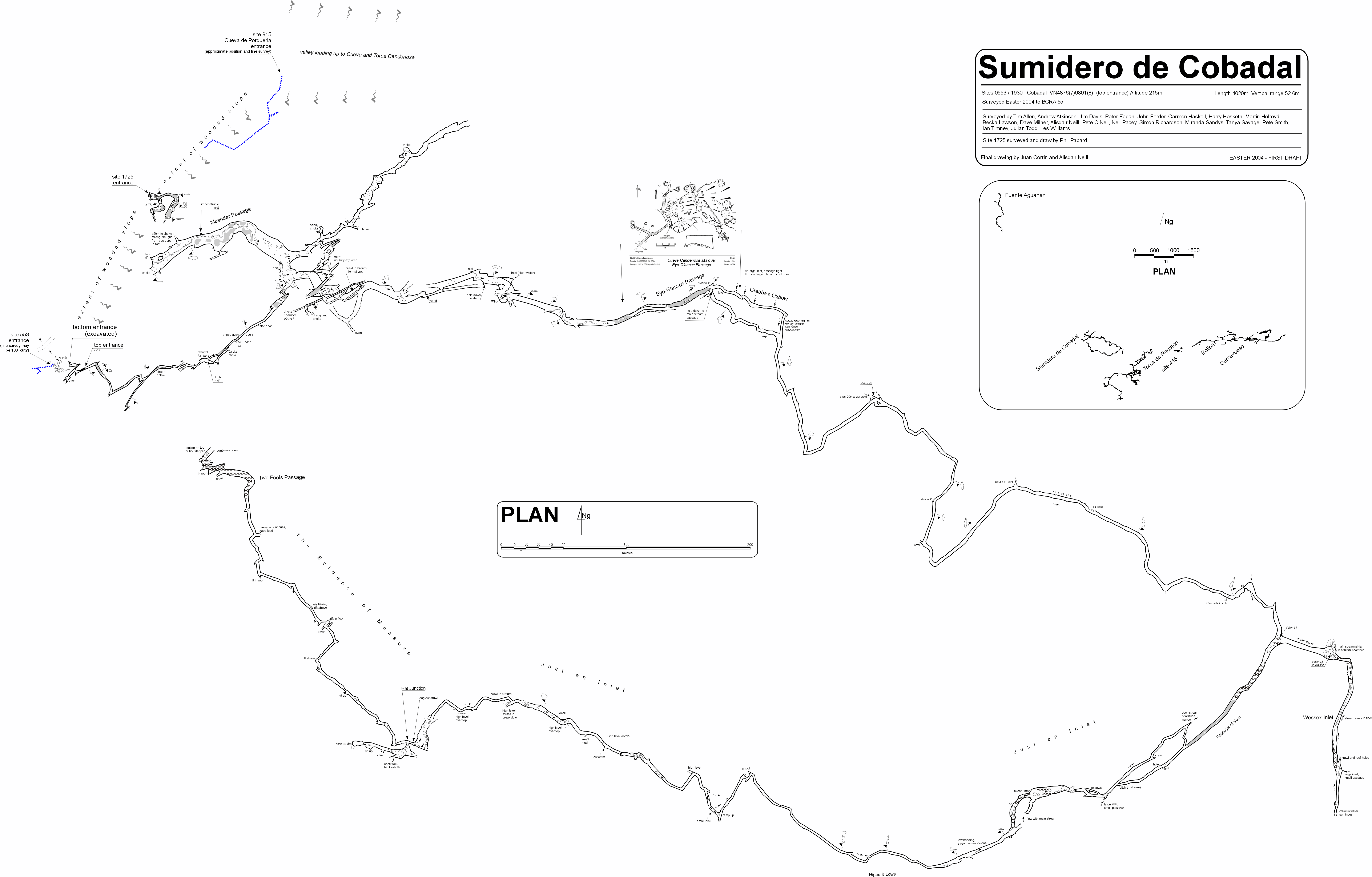
1930: Cobadal, Sumidero de
Cobadal Top entrance 30T 448666 4797809 (Datum: ETRS89. Accuracy code: A) Altitude 219m
Bottom entrance
30T 0448752 4798020 (Datum: ETRS89. Accuracy code: A) Altitude 203m
Length 7493m Depth 101m Vertical Range from 232m (Top Tip) to 130m (downstream soakaway)
Area position : Resources : Logbook search
Updated 5th, 16th May, 13th June, 6th, 24th August , 14th October, 6th
November 2004; 22nd February, 11th October 2005; 1st February, 20th May 2006;
8th, 27th October 2007; 16th April, 8th November 2008; 7th, 19th May 2009; 26th June 2010; 6th January, 14th May 2011; 1st July 2018; 18th May 2023
Entrance Series
The Top entrance is above and to the east of the sink. A strongly
draughting rift has been enlarged to allow entry. A 6m drop enters a very
tight descending tube that has also been enlarged. Below, a climb down enters
the passage coming in from the bottom entrance.
The Bottom entrance has been excavated in the cliff-lined hollow
containing the sink and cave 553. A slide down over
mud and boulders into a small, solid chamber is followed by a flatout crawl
round to the right that emerges in a small enlargement. (Carrying straight
on at the base of the entrance slope enters a wet, 1m wide bedding with a
good draught but low airspace).
On the right leads to a small aven, and to the left passes under the route
from the top entrance. The passage continues mainly stooping or hands and
knees crawling. After about 140m a small chamber is met where a climb up
a rift on the right takes the draught, leading to Loop Pitch and Pinnacle Passage.
Continuing past the chamber the main route reaches a bouldery chamber where
the stream enters at several points on the left; there is usually no flow
here in dry weather. The water has not been pursued upstream.
Loop Pitch
The Loop Pitch route goes off the entrance passage, where a rift goes
up on the right from a small enlargement. This climb rises 11m to a calcite
choke. About halfway up, another rift on the right becomes small and then
enlarges at the top of a 5m ladder climb. In summer 2007, a bypass was discovered
that cuts out the pitch entirely: The Samurai Tiger Bypass sets off
lower down the rift, on the right, and two left turns brings the explorer
out into Pinnacle Passage, about 15m southwest of Loop Pitch.
The remaining 200m of passages beyond the bypass turnings are generally small
and end in digs which appear to be heading towards site
2091 at the base of the hill southwest of the entrance.
At the base of Loop Pitch, 5m high Pinnacle Passage, sets
off in two directions. To the northeast, a calcited boulder choke (probably
from the surface) is met where routes may exist over the top and straight
on towards another choked passage about 15m away. During wet weather, a large
stream enters at this end.
To the southwest, the walking size passage passes floor pinnacles and then
becomes smaller with broken calcite on the floor. A pile of boulders is reached
which should have "Station 228" marked on paper. This was the furthest point
surveyed by the Easter 2004 team that explored to here from the bottom of
the cave through Passage of Vom. The remainder of Two Fools
Passage and The Evidence of Measure is described below.
During the summer of 2004, a small high level series was explored connecting
Pinnacle Passage with Two Fools Passage. Taters Deep, Mountain
High is reached via the rift continuing northwest from station 228. The
narrow route splits: the passage straight ahead becomes too tight and the
passage to the left also splits with all routes ending up about 5m above
Pinnacle Passage opposite Loop Pitch. By climbing 9m up near
the start of Taters Deep, Mountain High a "very good looking" high
level passage is reached with a flat roof. This heads south west for 40m
but closes down. Part way along there is a bouldery climb down to the boulder
pile at station 228.
Meander Passage and Maze Area
From the bouldery chamber, going left follows large passage with fine
incised meanders in the silt floor formed by a small stream.The end chokes:
a route through boulders on the right following a strong draught comes to
within a few metres of the boulders in site 1725. (This has been confirmed
with a voice connection). Near the start of Meander Passage a well
decorated passage on the right runs for about 200m. Near the start, a route
off on the right enters a maze of rifts, not fully explored. One passage
ends at a choke close to Pinnacle Passage. There are a number of
connections down to the main streamway.
In 2007, a passage up on the left near the start of Meander Passage was entered
via a 4m climb up. Wounded Knee Series is a complicated set of smallish
passages with some good formations and deep mud. At Easter 2008 this was
surveyed down into Meander Inlet (survey batch _08_01)
In the same year, the passage heading off to the north east (NB Passage)
was confirmed as ending in a stal and mud choke and all side passages had
nothing of any note.
On a trip in October 2008, it was confirmed that another unsurveyed pretty
chamber exists in this area.
Main streamway down to Eye-glasses Passage
From the bouldery chamber, the stream runs off right and can be reached 40m
further by taking a sandy crawl. Another 40m downstream, just after a low
section with formations, a passage on the right links back to the stream;
on the left a passage connects to an aven with passage visible at the top.
A climb before the aven up a rift connects to the Maze Area. Continuing
downstream, for the next 150m there are several levels of interconnecting
oxbows, with a number of small inlets. At about 300m from the bouldery chamber,
traversing above the stream on the right enters Eye-glasses Passage.
The Eye-glasses are a pair of parallel tubes. Some 70m above Eye-glasses
Passage is the large chamber in Cueva Candenosa and
the pitches in Torca Candenosa.
The main streamway can be regained by following an inlet down to the right,
while to the left Grabba's Oxbow sets off for 90m. This rejoins the
main stream just beyond the sumpy section. This is much smaller than the
previous oxbows but has many small inlets entering along it's length. The
largest, at the beginning, becomes very tight. However, the next inlet is
the route to a dry bypass to this section and continues unexplored beyond
a few blocks.
The streamway continues past formations to Cascade Climb which is
a 3m handline climb (bolt belay). Within 15m a 5m pitch is met (bolt &
thread belays). A climb across the top of the 5m pitch enters an alcove.
Beyond ,the stream can be followed, or a high level route can be followed
from just after the ladder pitch. Both passages meet a bouldery chamber where
the water disappears. This was pushed down and up during the summer 2004
expedition. About 50m after the pitch, in the stream, the T4 Inlet enters on the right. This begins as stooping passage which soon degenerates into crawling in water. The end is quite sharp and becomes too tight to progress.
Following the water down through the boulders passes one squeeze and the
stream then descends steeply to the head of an 11m wet pitch. At the base,
the way on is under the deluge and down a boulder slope. The bottom levels
out and the water sinks in a small hole near an apparent fault (altitude
127m). An alternative route down exists to the east, beyond the p11 where
an 8m pitch drops to a tight route through to the base of p11.
"Upstairs" in the boulder choke has been enlarged and boulders removed. The
possible route onwards appears unstable with boulders in clay. This was last
looked at during Easter 2009, when another leg was surveyed.
On an 8-person trip to the boulder chamber
on April 13th 2006, about 21 litres of optical brightener solution (containing
2.1kg of Tinopal CBS-X) was poured into the water. Cotton wool detectors
were installed at Los Boyones, a
resurgence at Arronte and at Fuente
Aguanaz. The OBA was successfully detected at Fuente Aguanaz after 5
to 7 days. This result obviously begs the question: Where is all the passage
that is feeding 900 litres per sec average flow to Fuente Aguanaz?
The paper documenting the equipment, methods and results can be read
here.
Some suggestions as to where else the water may go to are outlined
here.
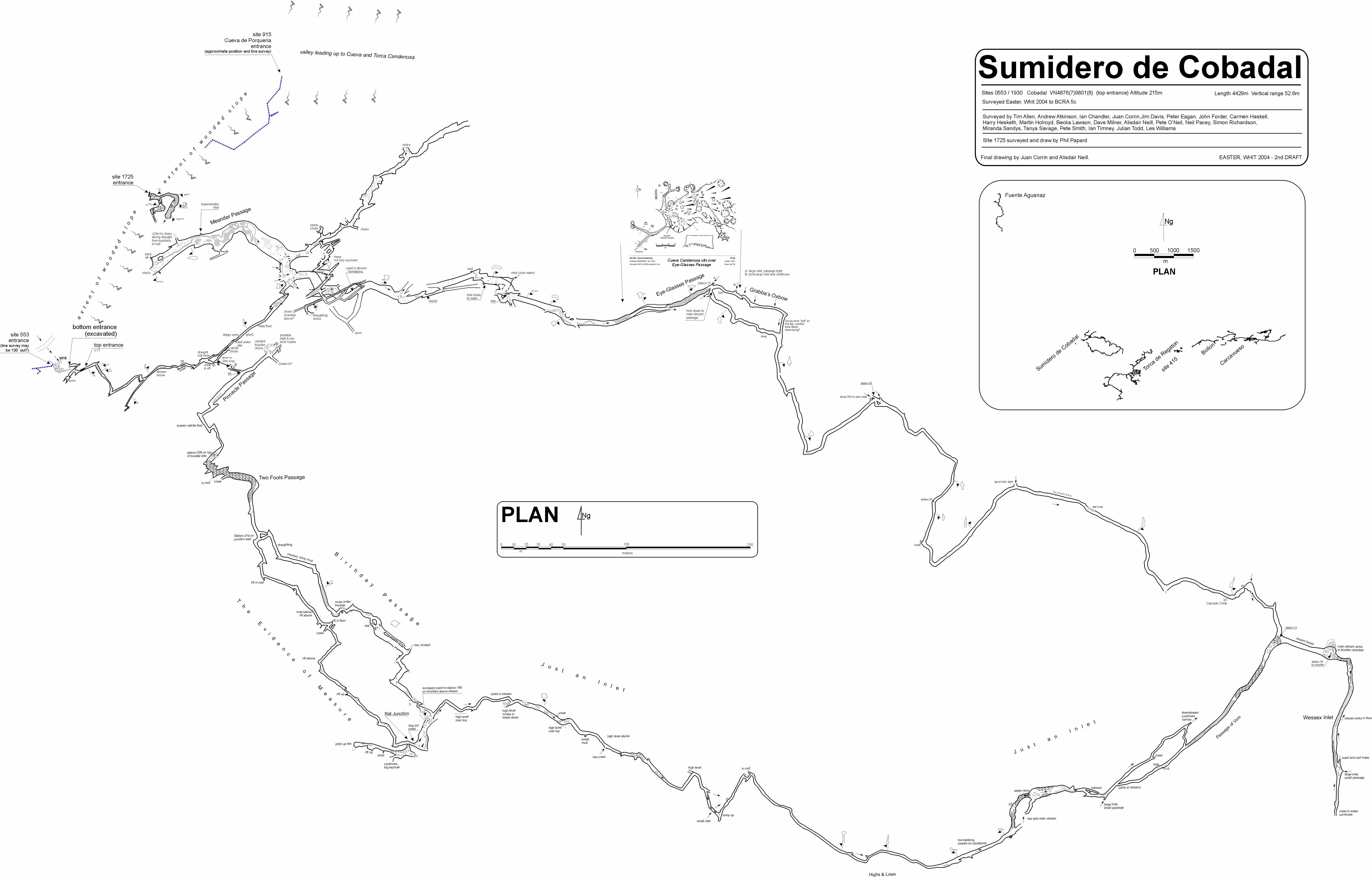
Wessex Inlet
In the eastern side of the chamber, in the roof, the Wessex Inlet goes
off. A wide stooping height tube leads off until the inlet stream is met
coming towards you and sinking in the floor. Shortly after, the inlet splits
with a good portion of the water coming from a small passage on the left.
A dry side passage goes off here to a crawl with several echoey pocket avens
overhead. Continuing on, the inlet gets smaller over the next 100m until
a low wet bedding is met which sumped. This was dug in October 2004 to allow
the sump to drain. Further progress has been made along the passage through
tight and chiselled sections to where a "calcite island" is reached with
water all round and a draught. A wet suit is now required to make further
progress. The site was pushed slightly further at Easter 2006.
Passage of Vom and Just an Inlet
Thirty metres before the boulder chamber is reached, this major inlet comes
in on the right. It is entered from the high level route below the 5m pitch.
The passage begins dry for 50m to a side passage on the right which leads
down to the stream. Continuing straight on leads to a climb and continuation
to emerge as a pitch down to the stream (not descended). The streamway gets
bigger as progress is made upstream. Part of the water comes from a low calcite
crawl on the left. The passage continues to a 10m wide breakdown chamber.
The streamway gets low in a bedding on the left, but the way on is up a mud
bank at the end of the chamber. At a 3m pitch back down, the streamway can
clearly be heard.
Beyond this drop, best rigged with a ladder the streamway is regained, which
continues as a low wide bedding on sandstone. By keeping to the left most
of this section can be passed by crawling. Soon the passage increases in
size to a tall narrow rift with a roof tube occasionally visable (the Highs
and Lows). There are a number of places where it is necessary to climb
up over jammed muddy boulders. Eventually the stream issues from an immature
passage on the right, with the way on up and down several muddy ramps, before
returning to the main stream passage.
The passage widens and there are more breakdown blocks. At one blockage it
is necessary to crawl with the stream. At a second large blockfall the streamway
soon becomes too small and the way on is up balanced blocks to the much larger
roof area. A dug out crawl to the right at roof level leads to Rat
Junction. Old fossil passage leads in both directions.
Right was originally followed for approximately 500m (The Evidence of
Measure) in passage 2x1m with some breakdown, but enlarging to 4x2m near
the end. After about 300m a junction is met (marked station 219) with the
righthand route being Birthday Passage, described below.
The end station (marked station 228) for the Easter 2004 explorations was
left on the top of a small block fall in Two Fools Passage with the
route continuing beyond. (This has now been connected via a 5m pitch up to
the entrance series: see description above).
Birthday Passage
Starting at station 219, two routes combine in walking size passage floored
with shiny, cracked mud. A section of passage with a rift in the floor is
followed by a breakdown area with a climb up over boulders and a slide down
under blocks. One of the best decorated sections of the cave is then reached,
followed by more walking passage until the route becomes small. Ahead appears
to choke while a couple of short crawls to the right combine on the boulders
above the stream at station 180, near to Rat Junction. Birthday
Passage Extension is high level breakdown that continues east above the
stream. It is possible to climb down at a number of points.
Going south at Rat Junction enters a chamber with station 230. The
obvious route to the west leads over breakdown to a pitch up after 50m. This
has been climbed by throwing a ladder over a stal to gain half the height
and then throwing a rope through a thread at the top. A rift passage starts
well but after a 5m climb degenerates into a narrow rift and closes down
after 50m.
Big Keyhole Series
The passages in this area appear to collect water from the east - west valley
to the south of the cave entrance. The higher routes end in chambers with
sandstone beds and breakdown, while the lower routes carry the water to Just
An Inlet.
Back in the chamber with station 230, a passage on the southern wall leads
to a short climb down into a rift passage which goes north and south.
To the north, after a grotto is reached, a small hole in the floor leads
to a junction. A flat calcite floor leads to a blockage to the northwest
after 15m. To the south, a large chamber in entered with calcited inlets
flowing across the floor from bouldery areas.
To the south in the rift, a short crawl emerges at the top of a 4m climb
down into another sandstone chamber (with station 10) where water flows down
to the north. A mud-floored tube at the low point links to the water through
a small boulder choke. The water can be followed downstream to a complicated
area of breakdown where it is possible to climb up to station 180. Upstream
has been followed for about 100m to a sandstone floor and a 20m drippy
aven.
Two routes from the chamber lead to a third sandstone chamber (with station
13). A 7m climb at the southwest end of the chamber leads to twin, 25m avens.
At the southeast corner, upward trending passage leads into Top Tip,
blocked with breakdown. A 3m climb to open passage on the northern side of
Top Tip has yet to be climbed.
Just an Inlet Inlet
This is another series of passages that bring water into Just an Inlet
from sandstone breakdown chambers and along sandstone-floored stream passages.
The series ends in high avens and draughting slots. A passage carrying water
to the east joins Just an Inlet at floor level.
Evidence Oxbow Series
This has been pushed through boulder breakdown to a series of passages with
several leads still open and draughting. These were pushed in the following
year.
The crawl at the end of the series continued for about 30m through very small
passage to where it became too tight with a boulder blocking the way. The
inlet on the southern side of side of the Oxbow Series continues for about
40m upstream through rift passages just above stream level to a small chamber.
The passage continues west with a flowstone floor. At the end, the passage
becomes lower with a mud floor. A restriction has been excavated but the
passage ends. From the chamber, the stream could only be followed for a short
distance (unsurveyed).
The original explorers in Just an Inlet, stopping about 70m from the
entrance passages took two and a half hours to retrace steps back to daylight.
This point takes about 30 minutes to reach via the rift and Loop Pitch.
The disappearing downstream water is about 700m from a flowing sump in
Torca de Regaton but the Wessex Inlet comes
to within 330m of the same cave.
The first round trip was completed on 20th April 2006, entering the dry series
first down through Vom Inlet and returning up the main stream.
Over three days in July 2011, the upstream course of Fuente Aguanaz (or, at least, part of it) was dowsed. The furthest point reached was a small sink close to the entrance of the Sumidero de Cobadal (site 2091). High above a supposed downstream route, on the north side, 3 wide reactions were noted. See the links below.
Link to entry in the Cave Diving Sump Index.
References: anon., 2003c (summer logbook); anon., 2004b (Easter logbook); anon., 2004c (Whit logbook); anon., 2004d (summer logbook); anon., 2004e (autumn logbook); anon., 2005a (February logbook); anon., 2005b (Easter & summer); Corrin Juan, 2005; Corrin Juan, 2006a; anon., 2006b (Easter logbook); Corrin Juan, 2006 (survey); Corrin Juan, 2007; anon., 2007b (Easter logbook); Corrin Juan and Smith Peter, 2007 (photos and survey); anon., 2008c (Easter logbook); Corrin Juan, 2007a; anon., 2008f (autumn 2008); Corrin Juan, 2009; anon., 2009a (Easter logbook); anon., 2010b (Easter logbook); León García José, 2010 (Volume 1 and Volume 2) (survey); anon., 2011b (Easter logbook); Papard Philip, Corrin Juan and Smith Peter, 2014; anon., 2023b (Easter logbook)
Entrance pictures: yes : Collapsed bottom entrance, 2010-2011
Underground picture(s):
Pictures taken Easter 2009: Round trip and upstairs in boulder choke
Pictures taken 2007: NB Passage (off Meander Passage) and Wounded Knee Series
Optical brightener test, Easter 2006
Pictures from summer 2004 : Photos from Easter 2004
Video:
Short video recording some aspects of the round trip, Easter 2009 by Julian Todd (22Mb)
Snippets from summer 2004. Filmed by Juan Corrin with Ian Chandler,
Peter Clewes, Jenny Corrin, Nigel Dibben, James Gelling, Paul Gelling,
Gareth Goodall, Ashley Morton, Chris Wright, Jozef Ancák, Jana Ancáková, Peter Carný,
Pavol Cerven and Jana Cervenová.
Peter Clewes in the entrance Paul Gelling in the entrance entrance passages 1 2
early stream passage deeper water streamway 3 4 5 streamway - Ian Chandler
Paul Gelling on 3m climb James Gelling on 5m wet pitch Nigel Dibben on 5m pitch
Eye-glasses Passage Meander Passage Crawl near entrance down rift back from Loop Pitch
Up rift to Loop Pitch Loop Pitch 1 2 Pinnacle Passage 1 2 Two Fools Passage
Birthday Passage: 1 2 traverse boulders formations 1 2
Snippets from 2003
top of drop into top entrance lower down drop walk to the sink area in the middle distance
Detailed survey: first draft from Easter 2004 (540kb) Whit 2004 summer 2004 pdf file
Survey 6th draft July 2007 (1Mb pdf) 7th draft Sept 2007 0.7Mb Easter 2008 pdf 9th draft, May 2009 pdf
Line survey:
On area survey: Dowsing reactions close to this cave : All dowsing reactions in the supposed Fuente Aguanaz catchment. (Article about the dowsing carried out in July 2011 can be found here.)
Survex file: yes (Amended magnetic declination December 2013 to align with Eur79 grid and coordinates altered to fit ETRS89 datum, April 2014.)
cave with neighbours (Amended magnetic declination December 2013 to align with Eur79 grid and coordinates altered to fit ETRS89 datum, April 2014.)
Passage direction rose diagram: 1/7/2018