Updated 25th April 2005; 10th December 2006
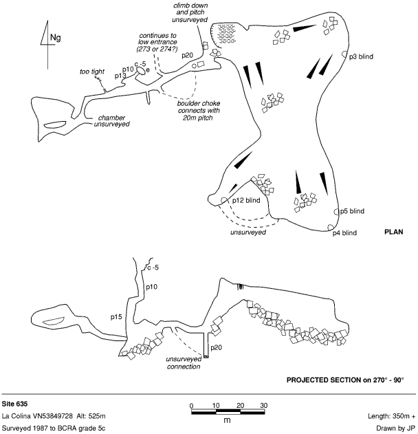
Top entrance (originally positioned at VN53849728; ETRS89: 30T 453738 4797071) lies above cliff and is
a 5m climb followed by a 10m pitch (marked M-2 in old red paint) to a tight,
draughting hole and a 15m pitch landing in a bouldery chamber.
To the west is a draughting bedding to three small chambers, the draught
disappears out along a small hole. To the east lies a window into a small
chamber and two obvious exits. Down leads through boulders to the base of
a 20m pitch; straight on, the route splits, the left way leads to the surface
through a series of crawls and squeezes, emerging at the base of the cliff
(probably in site 273) while ahead a muddy rift leads
to a traverse around the head of the 20m pitch and a climb up into a large
chamber (approximately 80m x 40m). The chamber contains a number of pitches,
all of which are choked.
((A site marked M4, pictured below, is more or less at the same position
and is a 1m diameter, 15m deep (undescended) hole. The nearby M5 is probably
site 1585.))
However, site 1585 is labelled "M5" as is site 273 in the cliff below. So it is likely that the position of site 1585 is really 635 and there is another hole around here. This won't be definitively cleared up unitl "635" is re-explored down through 273 to the surface.
References: anon., 1987 (logbook); material in file; survey; Corrin J and Knights S, 1988; anon., 2005b (Easter & summer)
Entrance picture : possibly; marked M4 (See 1585)
Underground picture(s):
Detailed Survey : 1:1000
Line Survey :
On area survey :
Survex file : yes (Amended magnetic declination December 2013 to align with Eur79 grid and coordinates altered to fit ETRS89 datum, April 2014.)