Updated 30th August 1998; 19th February 1999; 7th, 26th October 2001;
28th January , 8th June, 26th October 2002; 23rd January, 17th October ,
9th November 2003; 9th October 2004; 20th December 2005; 1st February, 15th
May 2006; 6th May, 27th October, 17th November 2007; 4th May 2009; 7th, 30th, 31st October, 2010; 7th January, 12th May, 23rd June 2011; 25th April; 25th September, 26th December 2012; 21st May, 17th September 2014; 27th September, 17th October, 1st November 2015; 20th May 2017; 30th June, 21st September 2018; 4th June, 12th September 2019; 24th May 2021; 16th February, 3rd March, 9th September 2022; 13th May 2023
[The entrances of this and site 331 were fixed by GPS in December
2002 and found to be about 70m west of the previous documented
positions. From 2015, the entrance is fixed from Google Earth. The grid reference above for the entrance is on the knob of rock directly above this climb down.]
Incomplete description
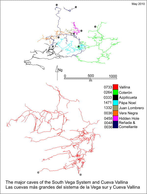
The length includes Cueva-Cubío de la Reñada (48), Torca de Azpilicueta (333), Torca de Papá Noel (1471), Torca de la Vera Negra (36), site 1338, Torca
de Coterón (264), site 675 and Cueva Comellantes (40). A table of the depth within the South Vega System from each entrance can be seen here.
The most used, (almost) top entrance to the South Vega System
(survey)and hence linked with
Cueva-Cubio de la Reñada (048) via Sanatogen
Passage, Torca del Coterón (264) ; since
1995, with Torca de la Vera Negra (Cabaña) (036) and, since 2012, with Cueva del Comellantes (0040).
The system can also be entered through site 1338 and
Torca de Papá Noel (1471). An
Azpilicueta-Coterón through-trip or exchange has yet to be made (at
least by British teams) but the Azpilicueta entrance is the preferred route
into the back end of Reñada (tackle list).
A pull-through trip has been carried out from Torca de la Cabaña to
Cubio de la Reñada, detailed in the description for Cabaña.
A slightly higher entrance, site 675, at an altitude
of 487m, has been connected through to Azpilicueta in pitches which have
yet to be properly gardened. This latter entrance connects above the 4th
pitch just before the meanders. The route has yet to be surveyed.
Aerial panoramas and video around the area were taken in August 2018: details to come.
The entrance shakehole contains a tree and a short climb drops into a low, rubble-floored chamber. At the base, a 10m climb down a block wall ends at a 5m pitch into a 6m high chamber with three holes in the floor. Pitch 1 ladder hangs over one of these and the 5 ladders required for pitch 2 are hung from it. The preferred SRT route is at the bottom end of the chamber. Eight metres down the ladder pitch is a ledge with a short length of passage, one part of which rises up to the highest hole in the chamber above and another length goes for 12m as a scramble to a choke. Thirty metres further down is touch-down on a level floor of cobbles.
The only exit is a narrow slot in the floor requiring one ladder. The SRT route links in below this slot. A series of cascades in a high rift now start, with 2 inlets bringing in water from the left - both of these choke. The climbs down end at the lip of a 28m pitch. This roomy shaft, lined with calcite, takes a steady dribble of water. The only outlet at the bottom slopes down to a complete passage change - the high rift is left and a 4m high by 10m wide stream passage passes from right to left. Upstream splits into a number of small passages, all of which become too tight. (Apparently extended in 1995, but not surveyed or described). Downstream, the rubble- floored stream has cut a 3m deep trench between banks of mud and gravel and after 30m the route ends abruptly at the head of a 15m pitch. A traverse on mud over the head of the pitch was completed in 1995 to go beyond the head of the big, main pitch, ending in the middle of nowhere. Up on the right, before the 15m pitch, a deep hole, lined with mud, accepts water from an "inlet" in the far wall.
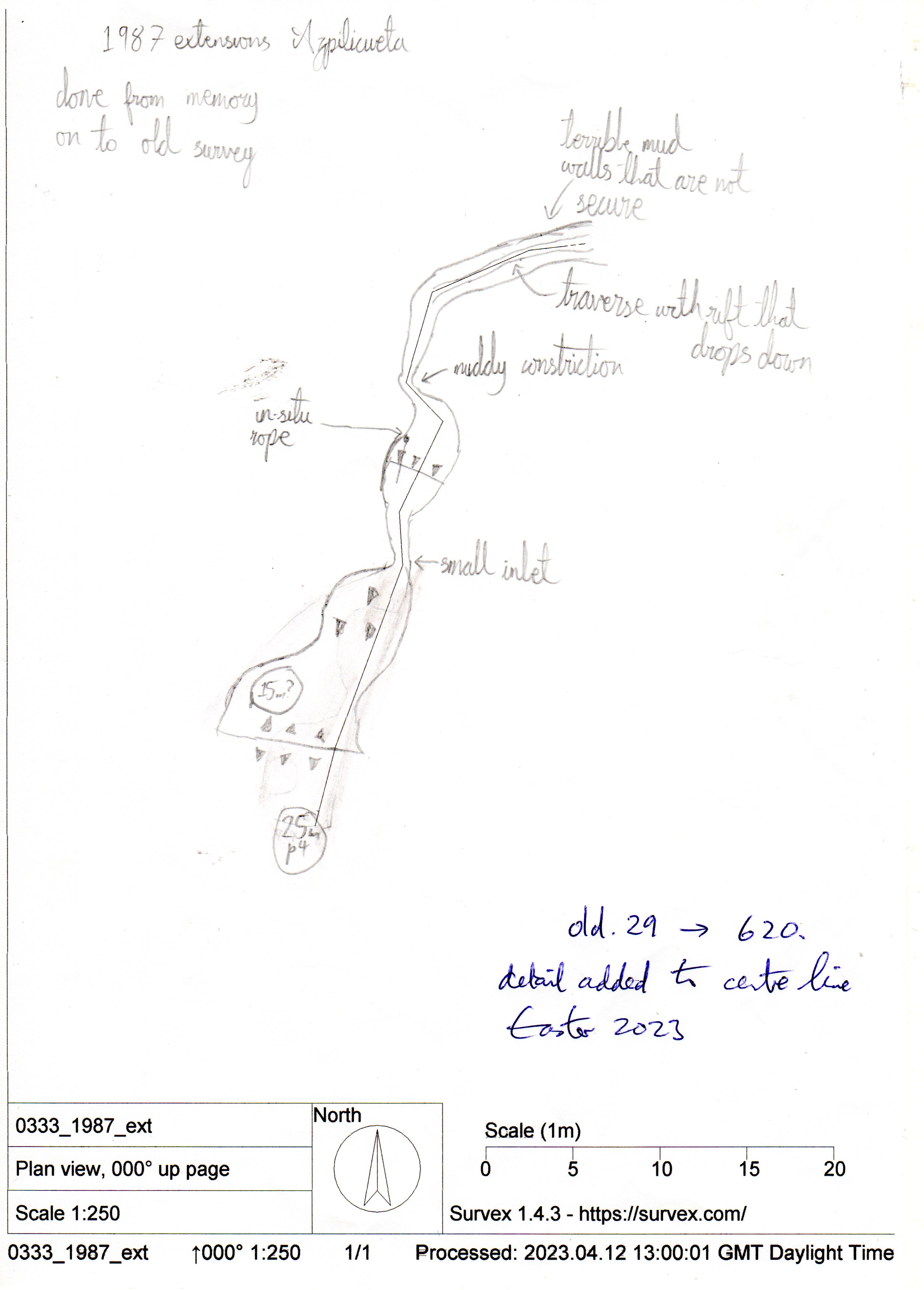
The 1987 Extensions, with muddy pitches, lie up this passage. Sketch detail was added to the centre line (stations old.29 - 620) on April 11th, 2023. The "final" pitch was not dropped, the top being described as "terrible mud walls that are not secure". (Sketch here)
Passage character changes back to high and narrow at the base of the 15m pitch. A short section of narrow, meandering steps are descended, ending at an large step down to the wet and windy head of the main pitch.
After 50m a landing is made on a roomy ledge. The drop continues immediately as a 15m pit down to another large ledge containing a pool and then a 40m wet pitch. After passing a ledge, the last 25m is a superb but wet hang into blackness through the roof of a large chamber. What at first appears to be the floor is a jumble of house-sized blocks, the landing being in a calcited pit from which the water sinks and is not seen again. The most obvious gap in the boulders is a 12m pitch into more closely packed chaos, followed by a further descent of 15m from which the only way on is by burrowing amongst loose blocks.
1984 & 1985 Extensions.........?
Reñada 2 requires a proper description here. From the base of the Giga Hall pitch, the streamway drops to the east into the sump that is Reñada sump 1. To the west, deep wading and swimming or lined traverses are required to negotiate the potholed streamway. The main water rising at the
end of the Rub-a-Dub Dubs (beyond Into-The-Tub Corner) had an exploratory dive by Mark Smith in 2002.
There would appear appear to be more water here than in the rest of the
(downstream) cave.
This sump was dived at Easter 2011 by Rupert Skorupka who passed Mark's limit to reach 150m and 17m depth in a gently descending, 4 - 5m wide tunnel. At the end, the roof was not visible. (Survey) There appears to be much less water in Squirrel's Passage in Reñada than in the Rub-a-Dub Dubs.
Reñada 3 extensions in 1991. In 1991, passages to the north of Wooden
Hill were extended and there may be a possibility of connection. There
also appears to be digs galore at the top of the Wooden Hill according to
a trip in 1993.
The 1992 extensions go off from coordinates 65, 60 approximately, and run
parallel to, and to the west of Sanatogen Passage. A climb up leads
to Santub Passage with a number of junctions. The end of Santub
Passage was dug through to a small gypsum chamber with 6 ways off. The
draught can be followed through boulders to an area of spongework and rifts
with holes in the floor. A descending tube to the left enters a larger passage
on a fault and to a black hole. A 14m pitch drops down the tube on the right
hand wall of the passage, avoiding a loose boulder slope. The landing is
on a big block in a large chamber - At the Opera - some 30m x 20m
in size. Most ways on are blocked. The draught and the main route appear
to continue down a 12m pitch into G.B. Chamber with a steeply sloping
sand floor. There appears to be no outlet or draught in the chamber.
In the summer of 2004 Torca de Papá Noel was linked to At the
Opera beyond Torture Chamber Grotto.
In 1993, some passage was surveyed off the Coffin Levels. In 2000, the survey up in the final chamber was completed to show that this was within a few metres of Torca de Papá Noel (site 1471). The Cork Screw Pitch Series was also entered but continues unexplored down a 15m pitch with a tight top.
The top of the Giga Hall pitch was traversed around to enter passage in 1993. A rising and loose traverse which needed about 8 studs enters some 250m of passage, ending at a 100m x 30m chamber, heading towards Mega Hall. A couple of 20m pitches in a small maze area have not been dropped. This area was photographed in 1995, although the route up is not easy.
Samples of stalagmite were removed from the cave for dating in 1993.
During the summer of 1995, the upstream area of "Reñada 3" was pushed by digging at the terminal choke. A blockage of sand and boulders was removed and entry gained to a small chamber with the sound of the river emerging from cobbles in the floor. This area was excavated to a depth of 2m to another opening with more digging to a jammed block and a strong draught. The block was removed but the route through was too small. A roaring rift was widened with hammer and chisel but again, no route through is possible.
A climb down to water has a roomy sump and twiglet-like chert on the walls. Above the sump is the Twiglet Zone, a narrow crawl over the top. This leads after 10m to an alcove on the side of the main stream, 2.5m wide and 3m high. A crawling oxbow leads past a deep plunge pool and a 1m cascade. Fifteen metres of walking and wading leads to a 1m cascade and a wade into a deep pool. After 40m of sporting passage, two areas of boulder choke are met. The main water appears to well up out of a sump. A small inlet comes through a boulder choke which requires a lump hammer for further progress.
Shortly before the end of "Reñada 3", a wide slope leads down to a lake, which can be waded across to a large sump pool with a wide chamber sloping up to the right. In the left hand wall of the chamber a 2m climb connects to a small passage which meets a stream. Following this upstream, crawling leads to a slope up and a sandy route to the right ending at a pitch into a chamber. Passing between boulders to the left at the top of the climb leads to some crawls, while a slot leads to a route through boulders, discovered at Easter, 1996 into the large Easter Bunny Chamber. The stream comes down a 2m cascade, climbing up which leads to a stream passage.
The stream passage, China Syndrome, was explored in one trip in August 1996. The passage starts as relatively easy going in low passage with cobbles. A number of inlets are passed, not all of which have been fully explored. At about station 5 one side passage ends at a circular chamber after 5m. Looking upwards a passage is seen to continue. This is an easy stomp along a sandy floor to a climb above into a blind chamber. Continued crawling leads to a junction where turning right over sand and right again up a steep tube leads to a rift passage. Passing a chamber with possible side routes, continuing passage leads into a well decorated area, where a right turn connects into the west end of China, a large chamber where the roof is a very high, 50m+ aven and the draught is entering from here.
Attempts to climb up around here in 1998 appeared to prove that a connection with Cueva Vallina would be easier to find from the Vallina side.
Back at station 5, ahead is a long crawl which leads to the eastern end of China.
The top of a 50m aven in this area would still be apparently 250m north of
and 70m below the nearest point in Cueva Vallina (733).
Link to entry in the Cave Diving Sump Index.
Logbook accounts
Reñada "2, 3, 4" etc
1995: 5th August 8th August
1996: 8th April
Pull-through trip, 31st July 2022
Pitch Notes (Easter 1997)
References: anon., 1982 (logbook); Addis F, 1982 (survey and photo); Corrin J, 1983c (survey and photo); anon., 1984 (logbook); Barrington P and Hanson D, 1984; anon., 1985b (logbook); Corrin J, 1986; anon., 1986 (logbook); Corrin J, 1987; material in file; anon., 1987 (logbook); Garcia J L, 1987; Corrin J, 1983a (survey); Corrin J and Knights S, 1988; anon., 1988 (logbook); Davis J and Corrin J, 1989; anon., 1991 (logbook); Corrin J, 1992a (survey); anon., 1992b (logbook); Stacey P, 1992; Corrin J, 1992b (survey); Corrin J and Quin A, 1992; Duffy R and Matienzo '92, 1992; Corrin J, 1993 (survey); Cawthorne B, 1992; anon., 1993b (logbook); Quin A, 1993a; Openshaw S et al, 1993; Ogando Lastra E, 1993; Corrin J, 1994a; Corrin Juan, 1995b; anon., 1995c (logbook); Corrin Juan, 1995a; anon., 1996a (Easter logbook); anon., 1996b (logbook); Corrin Juan, 1997a (survey); Corrin Juan, 1997b; anon., 1997b (logbook); Corrin Juan, 1998; anon., 1998d (logbook); García José León, 1997 (survey); Corrin Juan, 1997c; Corrin Juan, 2001; Corrin Juan, 2001a; anon., 2002e (February logbook); anon., 2002b (summer logbook); anon., 2002d (Christmas logbook); Corrin Juan, 2003c; anon., 2004d (summer logbook); Corrin Juan, 2005; Corrin Juan, 2006; Corrin Juan and Smith Peter, 2007; León García José, 2010 (Volume 1 and Volume 2) (survey and photos); anon., 2011b (Easter logbook); anon., 2014c (summer logbook); Papard Philip, Corrin Juan and Smith Peter, 2014; anon., 2015c (summer logbook); anon., 2017b (Easter logbook); anon., 2018c (summer logbook); anon., 2022a (January, February logbook); anon., 2022c (summer logbook); anon., 2023b (Easter logbook)
Entrance pictures : 2003-2017 : 2022
Underground picture(s): yes
Detailed Survey :
| 1982 | known cave (plan) | low res | high res |
| 1982 | known cave (elevation) | low res | high res |
| 1983 | on area map | needs scanning | needs scanning |
| from rescue site | simplified Azpilicueta, Reñada, Coteron | low res | high res |
| (2010) | scan of end sumps & China Syndrome | pdf file (12.3Mb) | |
| (2010) | annotated sumps survey (PP) | Word doc | |
| (2010) | annotated sumps survey additions (JD) | Word doc | |
| (2011) | sketch survey of Into-the-Tub sump | jpg | |
| 2011 | SVS hydrology diagram (Terry Whitaker) | ||
Line Survey :
On area survey : No detail on the South Vega System line survey : On scanned 1982 South Vega System survey : sketch of stns old.29 - 620 (April 2023)
Survex file : stand alone (Amended magnetic declination December 2013 to align with Eur79 grid and coordinates altered to fit ETRS89 datum, April 2014.)
download South Vega System (after summer 2019) (Amended magnetic declination December 2013 to align with Eur79 grid and coordinates altered to fit ETRS89 datum, April 2014.)
Miscellaneous : Early (1982) explorers and tackle 1 2
Passage direction rose diagram: South Vega System (30/6/2018)