Updated 30th August 1998; 19th February 1999; 27th July 2000; 23rd February, 7th, 26th October 2001; 28th January, 8th June 2002; 16th October, 9th November 2003; 2nd May, 13th June, 9th October 2004; 20th December 2005; 1st February , 15th May 2006; 27th October, 17th November 2007; 16th April 2008; 7th January, 23rd June 2011; 26th December 2012; 2nd December 2014; 25th September, 17th October 2015; 21st April 2016; 30th June 2018; 3rd March, 9th September 2022
Incomplete description
The grid reference is the taken from Google Earth and is the top of the slope down to the pitch head.
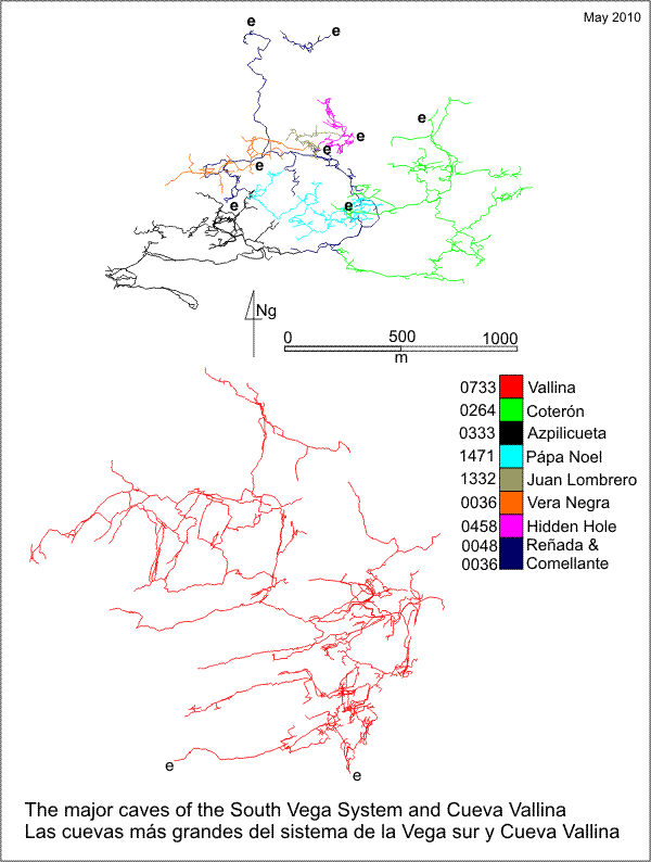
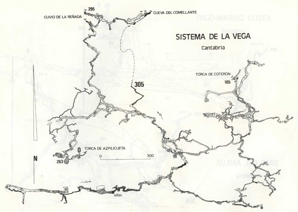
The length of the South Vega System includes Cueva-Cubío de la Reñada (48), Torca de Azpilicueta (333), Torca de Papá Noel (1471), Torca de la Vera Negra (36), site 1338, Torca
de Coterón (264), site 675 and Cueva Comellantes (40). A table of the depth within the South Vega System from each entrance can be seen here.
This is one of the high level entrances to the South Vega System. The other entrances
to the system are Cueva-Cubio de la Reñada (048)
(lower and upper), Torca de Azpilicueta
(333), site 1338, Torca
de Cabaña (036), site 675, and
Torca de Papá Noel (1471).
The South Vega System (line survey) has developed broadly on 4 levels:
A hydrology diagram for the South Vega System can be seen here.
| batch reference | note | drawn by | batch description | total surveyed (m) | incl new (m) |
| 16-01 | level 4 | AN | no | 694.4 | 175.9 |
| 16-02 | continues 16-01 to top of 2nd p | RN | no | 98.1 | ? |
Back at the junction, a boulder floored passage to the left descends to a
small dripping chamber with a pop-up on the right into a tall hading rift.
After a short walk and slither down, the large continuation of the rift is
entered as a walk down over boulders (past a choked 15m shaft) to the head
of the second pitch. Belayed to a massive boulder, the 3 ladders slope down
over sloppy debris to a 13m vertical climb against the wall of the rift.
The landing is on a steep slope of boulders with the route being down the
slope to a short drop between boulders. A further climb down over boulders
and a gentle stroll descends to the Edge of the World and the horizon
which has many kilometres of passage dissolved out of it.
Possible black holes above the second pitch proved to be nothing when investigated in 2014.
Level 3 passages
The sandy floor at the Edge of the World ends abruptly with a jumble
of boulders 5m down with the far wall of the chamber barely seen 30m away.
Explorations have been carried out down in the boulders - a depth of 30m
was reached and a connection with the first floor hole along the main route.
Over to the right of the Edge of the World is the entry point to Marvin's Marvels. A short scramble between boulders joins a large passage which continues for 400m to a calcite choke. The large tunnel is essentially horizontal though in places magnificent calcite formations and flows have conspired to force the odd clamber, slither or climb. Best after rainfall when the pools fill up, this passage is a photographers paradise with the full range of glistening calcite deposits; the best 'ooh-ah' passage in Torca del Coterón.
At the back wall of the Edge of the World is a steep sand slope which is the start of the 92m Ramp Series. Access to the slope is best gained by walking south into the hill and then doubling back along a smaller 3m high passage. At the top of the climb a short duck under the wall enters a roomy ramp which rises to the left over boulders passing a choked drop on the left. A short scramble over boulders leads to another boulder floored chamber.
At its far end there are two ways on. The first, up to the right, has a short phreatic tube descending sharply to a small chamber and the start of a complicated series of smallish phreatic passages containing a number of holes that have yet to be descended.
Lugger ...?
The second route is down to the left where a short hand and knees crawl around a dog-leg leads to a traverse over two holes to reach yet another large, boulder-floored chamber. A walk along the right hand wall leads to the passage just described while a climb down into the chamber and a short walk meets the chamber wall. Down to the left is a series of crawls between boulders that lead nowhere . Up to the right is a steep calcite slope and a short chimney up between boulders that pops up at the base of the ramp. The 20m wide passage rears up at 30 degrees and is initially floored with monster rocks and finally with calcite. A group of thick stal bosses give an excuse for stopping halfway up and a damp pitch in an alcove on the left at a slightly higher level has been descended for 15m to a very tight stream passage. The ramp ends with tricky climbs on calcite, having risen to within 15m of the entrance altitude (although still 70m below the surface at this point).
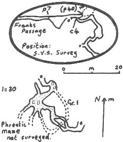
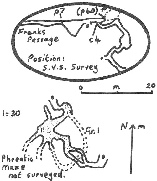
Back at the Edge of the World, a short walk into the obvious tunnel meets the hole in the floor previously mentioned. On the left of the hole are the twin entrances to Frank's Passage.
Of comparatively claustrophobic dimensions, the route starts as a walk on sand and rocks. A short traverse over a rift in the floor ends at a 7m pitch into a sandy-floored chamber. A chimney up the continuation of the rift enters a boulder-floored passage which ends at the constricted head of a 40m pitch, choked at its base. By negotiating a chossy climb on the right hand wall just before the pitch (2004: now has a rope), the main way on is entered. (1987 pitch down around here to connect with Bootlace Passage??)
A stooping height tunnel meanders about before entering larger passage and
a short climb up (2004: roped with a rusty ladder) into a tunnel which ends
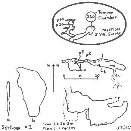
at a short crawl into Tampax Chamber. Cotton wool-like formations
lying on the sandy floor of this low chamber are gypsum. Back above the climb
is another short one up into a tunnel which slopes down to the head of a
20m pitch. (Just back from here, on the right in an alcove, is another short
pitch which chokes). At the base of the drop are two pitches both dropping
about 12m to a short crawl and an 8m pitch. Another ladder shaft drops into
a large chamber which is at about 197m altitude. A couple of leads (one a
hammer and chisel job into bigger passage) still need attacking. During the
summer of 2004, a small hole at the base of the p20 was enlarged into a small
chamber with a hole into a larger solution pocket. A crawl at floor level
led in a circle round to join the next shaft (p8) as a window.
Back at the top of the 20m pitch a steep ramp leads up on the right. This
was climbed (at Easter 2004; rope left on) to about 50m of new passage ending
in a mud choke. Two downwards ramps were passed where tackle is needed to
check out the bottoms.
According to a trip at Easter 2004 a good study of the survey is needed before
any effort is put into the leads as they could just be routes into Bootlace
Passage.
At Easter 2004,
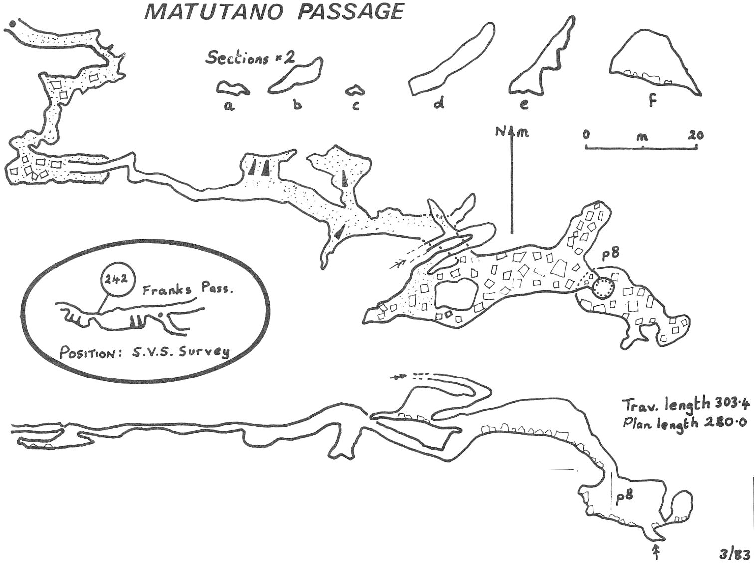
Further back in Frank's Passage, to the west of the 7m pitch is the small entry to Matutano Passage. The smallish, sandy- floored passage ends after 250m at an 8m pitch into a blind chamber with a draught emerging from the floor.
Popping back out of Frank's Passage and turning left, the main segment of Level 3 looms ahead. (Floor deposits are rather interesting along the whole of this level: sandstone cobbles, limestone breccia, sand with gypsum needles underneath and occasionally some spongy gypsum). A 70m walk in an 8m wide by 4m high passage drops down through a blowhole to the right and more walking to a junction.
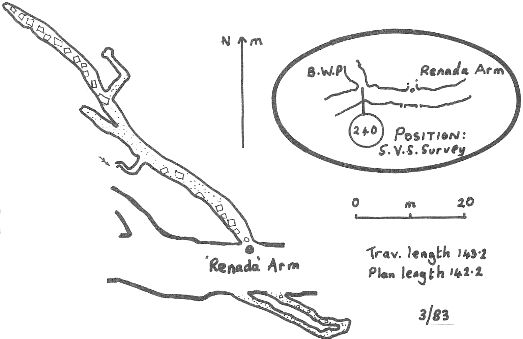
To the right, mostly walking progress ends at a 5m drop with an up and down bypass on the right. At the base a complex series of smallish tubes and rifts are almost joined with the middle chamber in the 92m Ramp series - pushing is still needed here. To the left at the junction, a slope of breccia is reached and the splitting of the routes down into Cueva-Cubio de la Reñada (048). At the top of the slope is the start of the Codisera Arm (which in fact goes nowhere near to that cave) and to the right, halfway up the slope is the draughting entrance to the Reñada Arm, heading off to the west.
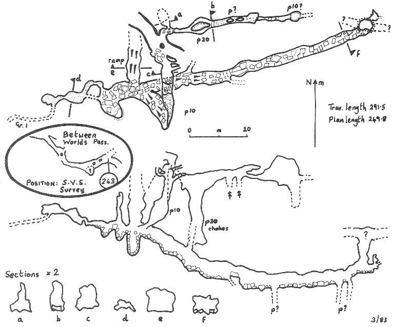
The whole of the 400m length of the Reñada Arm could be done at a trot; a spacious sandy-floored tunnel lures the explorer on, tempting him to forget about the smaller ones off to the sides. But taken in order from the start these are: a) on the right after 50m in a large cross joint, 2 tight slots unite in a flat out crawl, joining the tubes and rift passages just before the 5m pitch; b) on the right after a further 50m, a tight grovel at floor level; c) after another 30m, again on the right, a short walk to a roof collapse which should be easy to clear - has someone tried?????; d) Station 62, where a small grovelly loop lies at the base of the left hand wall and the opening on the right is Between Worlds Passage (see below).
The end of the Reñada Arm is heralded by a pleasant group of
orange and white stal and the passage then becomes rather smaller, ending
in a complicated collapse area. By sticking to the right wall and forging
straight ahead the passage appears to bypass the choke but ends, after a
5m pitch, in a choked, funnel-floored chamber (apparently not far above the
Ramp beyond Castle Hall in Cueva-Cubio de la Reñada (048)).
Just before the pitch, a boulder choke on the left holds the route up into
Paper Plane in Torca de Papá Noel (site
1471). This was discovered in the summer of 2003 and would now appear to
be the route of choice to the far reaches of Papá Noel.
Slightly further back and still on the right is a low crawl round to the
right which enters walking passage. The passage rises to the right, through
a section walled with limestone cobbles. Who remembers the rest of this
bit???
At Easter 2004, Roof Passages Extensions at the end of the Reñada
Arm added 85m in passages that rose 25m above the main level and ended in
a very low mud dig and at the base of a very narrow pitch up.
Down amongst the boulders ... Steve???
Down in the choke, a 15m pitch drops into 50m of passage ending at the head of an undescended 40m pitch - the base of which should be at about 180m, Reñada level.
A number of other dripping shafts have been descended in 1983 and looked at again at Easter 1994. These are reached on the left where a climb down followed by a climb up calcited boulders arrives at a pitch in the right hand corner. At the base of this 10m pitch a number of possibilities exist. Two pitches are found on one wall, one beneath a flake and another in a corner. Another pitch, which is entered through an eyehole leads to a 5m drop onto a large ledge. A rebelay allows a descent in two directions: to the left goes to a 20m pitch in a hading rift in crappy rock ending in a series of pits - the draught is lost here; to the right is a squeeze onto a sandy ramp popping out at a 5m drop into an aven. The floor of this has potential but is down through boulders and has not been pushed. The draught in this area is enticing since the Ramp must be very close.
Pushing over the choke - description.
Between Worlds Passage is a homely, boulder-floored passage with a number of pits. The first, on the right has been looked at and ends in two draughting, undescended pitches of about 25m(??). This presumably is what is on the computer survey.
Thirty metres on and passage goes off on both sides of the route: the right branch splits immediately as it comes to a rift, the northerly pitch of about 10m being unexplored(?) and the easterly pit choking 20m down. By traversing over the top, two draughting holes are passed over to another undescended 10m pitch with passage carrying on on the other side.(?)
The left branch is a steep climb down which levels out at the head of a 10m pitch into a large passage. Another steep slope down ends at a three way junction. Straight on is a steep, unfinished(?) ramp; to the left peters out after 40m, while to the right the bouldery floor conceals a couple of undescended pitches. This passage seems rather out of place, being perched between the Cueva- Cubio de la Reñada and Torca del Coterón levels.
Between Worlds Passage continues for 10m to a large step over or
tight squeeze around a hole in the floor. Immediately on the right is the
pitch entry to the 81 Depths, while ahead the passage enlarges and
a climb up boulders to the left enters a short walk down to the Edge of
the Universe. In the summer of 2001, site 1338
was linked to Coteron in this region, and part-way down the 81 Depths.
The Edge of the Universe is a pleasant spot away from the edge, the
top of the pitch is guarded by a semi-circular balcony of sand and loose
rocks. Luckily a short, narrow 'path' exists along the left hand wall to
take the explorer beyond this mess and to solid rock where convenient belay
anchor points are to be found in a couple of small alcoves. At Easter 2008,
a traverse over the pitch on the left entered passage which closed down after
15m.
The 70m pitch is straightforward, though rather damp. Initial landing is on a pile of large rocks jammed 20m off the floor; touch-down is on water-worn cobbles. The obvious passage from the base of the pitch chokes in dank phreatic tunnels. The route through to Cueva-Cubio de la Reñada is over a hole in the floor to the right and stepping into the body sized passage. After a short squeeze down through boulders, the route is obvious and ends, 30m or so from the ladder, on a veranda looking out into the start of Gallery of the Dead in Cueva-Cubio de la Reñada.
The 81 Depths is the technical route down to the same level, although frustratingly, not to Reñada. The entrance pit of about 30m is broken by a large ledge half way down and the passage then degenerates into a meandering, narrow canyon until a 16m pitch is met. From the foot of this a large chamber is walked into with a pitch at each end. Descending the westerly, 15m sloping pitch leads to a sandy passage ending below the right hand pitch. A climb down through boulders enters a small inlet and a choked way on. From the foot of the sloping pitch, 10m forward, there is a blind 8m shaft under a boulder on the right and immediately forward of this is a low, short crawl under the left wall with a 15m pitch in the floor. At the base, a scramble over boulders enters a large passage containing a small stream between mud banks. The water sinks about 30m further on, under the right hand wall, into a small phreatic passage with deep pools and an unpushed duck. (The water is presumably next seen as the small stream before Castle Hall in Cueva-Cubio de la Reñada). Beyond the water sink is an inlet which can be followed over boulders to an aven. The roof of this is passed over at the base of the Edge of the Universe on the route through to Reñada.
The Codisera Arm is another trunk route and this way becomes small after 300m. At this point the shattered limestone roof has collapsed and a flatout crawl is necessary, but for only a few metres. An enlarging passage is entered which swings to the right and rises dramatically on a sandy floor to a 20m vertical drop down the side of a rift with a high, dripping aven above. The base of the drop is reached by entering a hole on the right halfway up the slope. At the base of the rift there are several blind pots and other short passages; one of the longer passages ends at a 12m pitch with a short length of streamway at the bottom, ending at an altitude of about 186m. A connection is also made with a smaller meandering passage with some superb gypsum formations, like candy floss on the walls. A difficult steep slope remains to be climbed(?) and is one of the best possibilities for extension in this 300m series. In a small chamber near the middle of these passages lies the small entrance to Bootlace Passage and its kilometre traipse into Cueva-Cubio de la Reñada. (Bootlace is described in Reñada).
Better description of all this.
Some holes were looked at in the summer of 1993. Just past the "only formations in Bootlace Passage" a pitch in a chamber drops some 25m to a sump pool. A parallel pitch drops to the same pool. A traverse to the right of the chamber leads to a short passage and a 12m pitch. Water enters at the top from a too tight passage and exits at the base into a too tight passage.
According to Quin (BU pp59-62), in his magnetic
susceptibility studies, sediments from Torca del Coterón show
similar k values to sediments in Torca del Mostajo
on North Vega, indicating that the sites may have had a common morphogenic
agent and have been connected.
Link to entry in the Cave Diving Sump Index.
The speleo club Viana (from Guadalajara) have published a number of documents (descriptions & surveys, including gpx, pdf and jpg files) relating to the system. See their Cantabria page and the Zona de Matienzo section.
In July 2022, a three-person Coterón - Reñada pull-through trip via Bootlace Passage reported that the entrance pull-through was rather awkwardly rigged at the top ; the 2nd pitch was well rigged and that the rigging around Two Sumps Chamber in Bootlace Passage was a little worn but currently safe.
References: anon., 1981a (logbook); Corrin J et al, 1981a (survey * and photo); Corrin J, 1981 (survey and photo); anon., 1982 (logbook); Smith P, 1982b; Addis F, 1982 (survey and photo); Corrin J, 1983c (survey and photo); anon., 1983a (Easter logbook); anon., 1983b (logbook); Corrin J, 1983b (survey); Barrington P and Hanson D, 1984; anon., 1985b (logbook); Corrin J, 1986; Smith P, 1982a (photo); Corrin J, 1983a (survey); material in file; anon., 1987 (logbook); Corrin J and Knights S, 1988 (survey and photo); anon., 1990c (logbook Whit); anon., 1991 (logbook); anon., 1992b (logbook); Corrin J, 1992b (survey and photo); Corrin J and Quin A, 1992; anon., 1993b (logbook); Quin A, 1993b (survey); anon., 1994a (Easter logbook); Corrin Juan, 1995a; Quin Andrew, 1995 (survey); anon., 1998d (logbook); García José León, 1997 (survey); Corrin Juan, 1997c; anon., 2000c (Summer logbook); anon., 2001c (Summer logbook); Corrin Juan, 2001a; Corrin Juan, 2003a; anon., 2003c (summer logbook); Corrin Juan, 2003c; anon., 2003d (autumn logbook); anon., 2004b (Easter logbook); anon., 2004d (summer logbook); Corrin Juan, 2005; anon., 2006b (Easter logbook); Corrin Juan, 2006; Corrin Juan and Smith Peter, 2007; anon., 2008c (Easter logbook); Corrin Juan, 2009; León García José, 2010 (Volume 1 and Volume 2) (survey and photos); Corrin Juan, 2011; anon., 2014d (autumn logbook); Papard Philip, Corrin Juan and Smith Peter, 2014; anon., 2015c (summer logbook); anon., 2016b (Easter logbook); anon., 2022c (summer logbook)
Entrance picture : distant view shaft shaft from above shaft descending entrance shaft
entrance shaft 2004: 1 2
Underground picture(s): slope at base of entrance pitch : second pitch: 1 2 3 : photos from 1982, 1998 and 2004
Video: Espeleo50 Coterón - Reñada through trip from YouTube
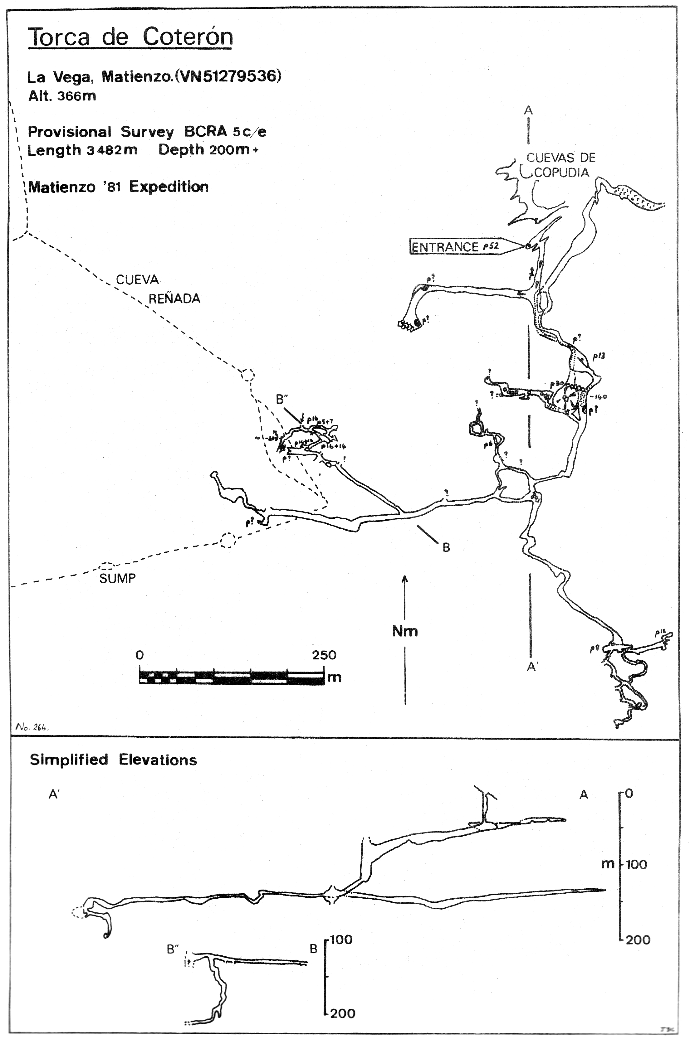
Detailed Survey :
| 1981 | known cave | low res | high res |
| 1983 | On scanned 1982 South Vega System survey | high res | |
| 1983 | extension before Tampax Chamber | low res | high res |
| 1983 | Matutano Passage | low res | high res |
| 1983 | Extension off Between Worlds Passage | low res | high res |
| 1983 | Extension off Franks Passage | low res | high res |
| 1983 | Extension off the Reñada Arm | low res | high res |
| from rescue site | simplified Azpilicueta, Reñada, Coteron | low res | high res |
Line Survey : No detail on South Vega System survey
On area survey :
Survex files : Coterón (with resurvey started Easter 2016) (Amended magnetic declination December 2013 to align with Eur79 grid and coordinates altered to fit ETRS89 datum, April 2014.)
download South Vega System
Passage direction rose diagram: South Vega System (30/6/2018)