Updated 19th February 1999; 8th November 2003; 5th November 2005; 15th April 2008; 6th January 2011; 20th April 2016; 30th June 2018
The track to the shaft was being improved with European money in the autumn
of 2005. The sign at the road junction called the area Cillarón.
The entrance is in a walled, wooded depression. This is often difficult to
locate, especially when overgrowing vegetation prevents boulders from rumbling
down the entrance pitch.
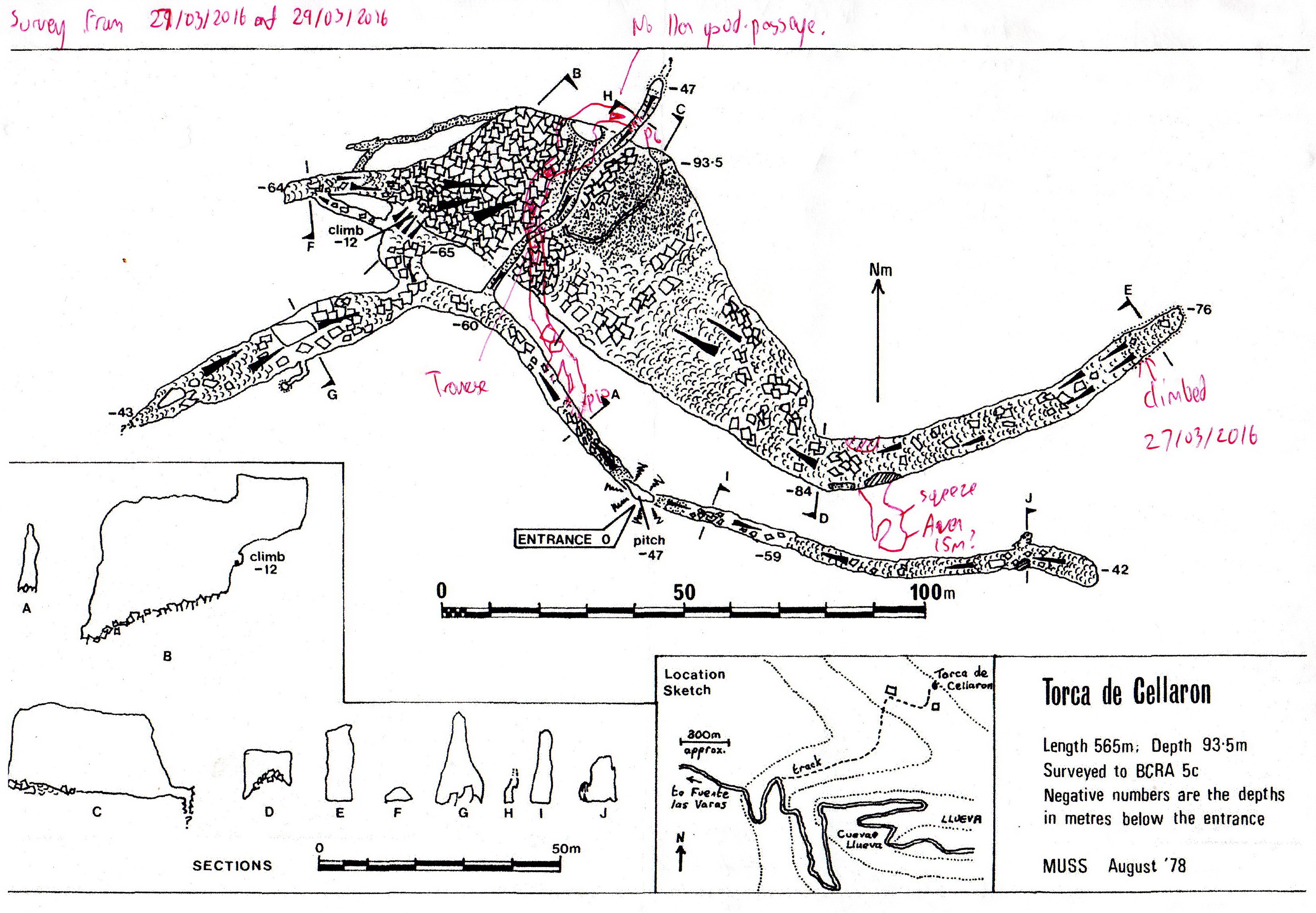
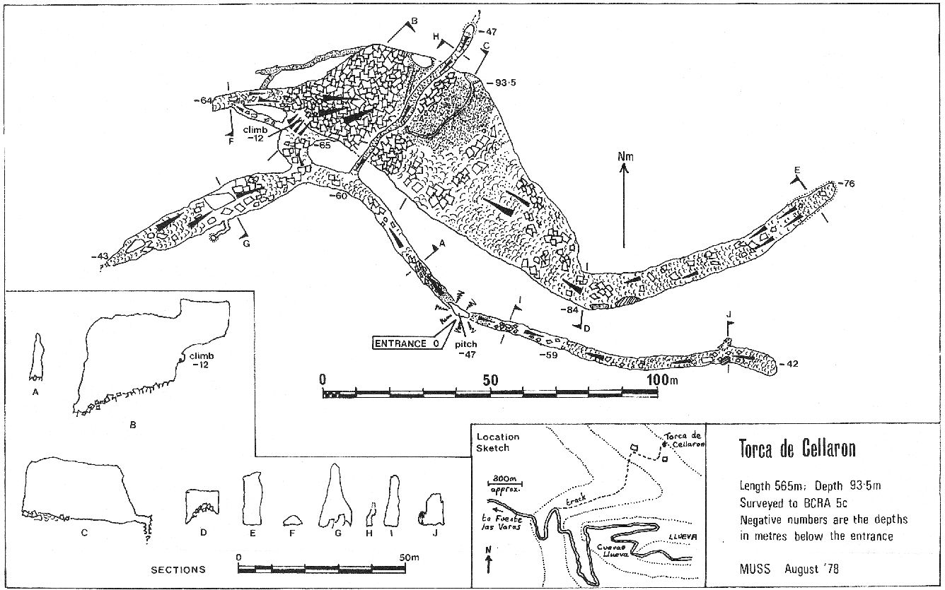
A fine shaft of 47m lands on a festering heap of remains. To the east, the walking sized passage ends at a calcite choke after 100m. About 50m from the end on the right there are some phreatic(?) rifts which could be easily climbed.
In the opposite direction, a gradually enlarging passage leads to a veranda looking down into a large chamber. just back from here on the right, a narrow, calcite-floored rift eventually closes down. On the left, before the veranda, a large passage ascends over boulders to a steep calcite slope. At the top of this, a well decorated section has a 30m choked pitch through a window on the left hand wall and a 15m choked pitch at its end. Four pitches in all? Proper description, Grovel!!?
The easiest way down into the blackness at the veranda is by stooping under the left hand wall to a boulder slope down to the right. The way on gradually enlarges until the passage attains a width of 50m. At this point a stream, cut into the sediment, sinks at a 15m choked shaft under the left hand wall. The main passage ascends gently to a calcite choke after a further 180m. There could have been high level passage here; climbing to it was started in 1993, and continued the following year, nearly reaching the top of a "very muddy bolt climb". At Easter 2016, it was described as "not going anywhere."
Another bolt route is visible in the middle of the main chamber where a roof tube comes in, although this could be associated with the 2016 Extension.
Another look in the cave at Easter 2008 failed to find any new leads. In 2016, a bolt climb up, about 20m northwest of the entrance pitch entered a passage that headed north over the main chamber. A traverse line is necessary to cross a p15 then a slippery slope up enters a small, flat-roofed chamber. The route then drops back down a slope to end at a pitch of 6m that drops into known passage - the smaller one that rises up from the entrance passage over the main chamber. The length of this extension has been estimated at about 85m and added to the length of the known cave. (See amended survey.)
Water draining from the lower reaches of this cave must drop into the unexplored streamway on the far side of the downstream sump in Cueva Llueva (114).
References: anon., 1978 (logbook); Corrin J et al, 1978 (survey); anon., 1980a (logbook); Corrin J et al, 1981b (survey and photo); Manchester University Speleological Society, 1982 (survey); Corrin J, 1980; Mills L D J, 1981; Mills L D J and Waltham A C, 1981 (survey); Corrin J S and Smith P, 1981; anon., 1986 (logbook); material in file; Garcia J L, 1987; anon., 1993b (logbook); anon., 1994b (logbook); García José León, 1997 (survey); Corrin Juan, 1997c; anon., 2005c (autumn logbook); Corrin Juan, 2007a; anon., 2008c (Easter logbook); León García José, 2010 (Volume 1 and Volume 2) (survey and photos); anon., 2016b (Easter logbook)
Entrance picture :
Underground pictures: yes
Detailed Survey : from 1978: low res high res : amended with 2016 extensions
Line Survey :
On area survey :
Survex file : yes (Amended magnetic declination December 2013 to align with Eur79 grid and coordinates altered to fit ETRS89 datum, April 2014.)
Passage direction rose diagram: 30/6/2018