Updated 19th February 1999; 3rd January, 26th October , 12th November 2001; 7th June, 11th November 2002; 14th October, 8th, 26th November 2003; 21st November 2004; 8th November 2006; 25th February, 27th September, 28th October 2007; 26th September , 20th December 2008; 29th October 2009; 6th January, 4th November 2011; 19th, 24th September 2012; 7th September 2013; 13th September 2014; 16th May 2015; 9th February, 14th October 2016; 1st, 30th June 2018; 11th May 2019; 3rd September 2021; 6th March, 4th September 2022; 9th May 2023; 6th, 19th January, 15th February 2024
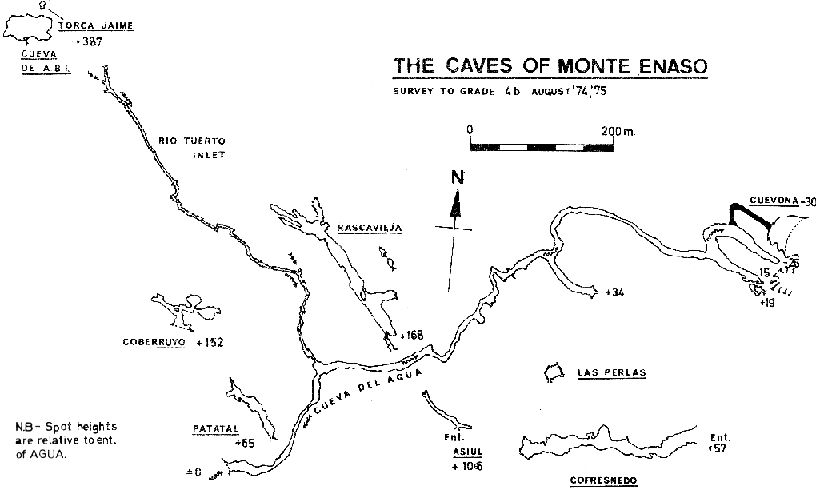
The sink for all of the water in the Vega branch of the depression. The cave provides an interesting wet trip.
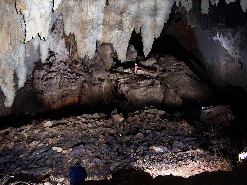
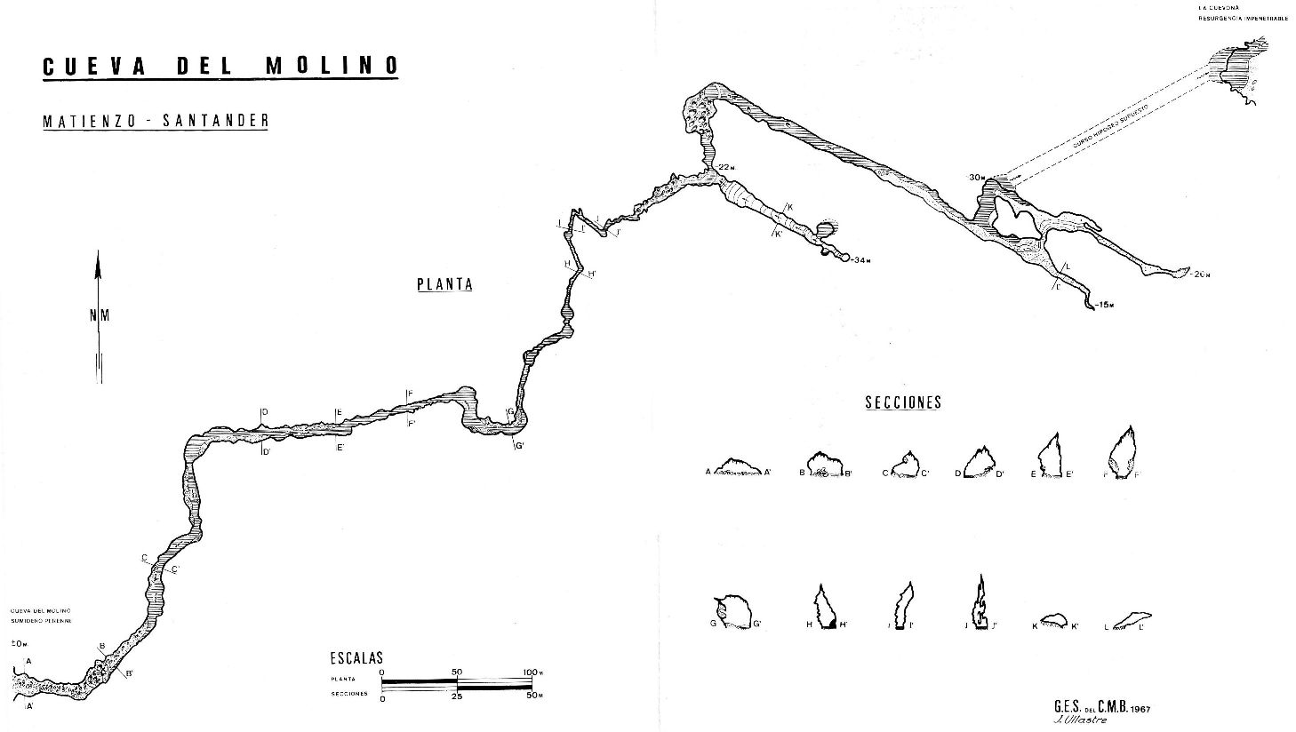
An impressive entrance at the end of the stream bed leads to a large, rock-strewn chamber at the end of which the water is met. The remainder of the main line cave is sporting stream passage - a mixture of wading, clambering and swimming in large passage. At the cascades, a high rift passage leads off for 60m with calcite flowers on the floor. The large sump pool at the end of the main passage has been dived through to La Cuevona (248), the resurgence.
On the left of the first lake, 200m from the entrance, is a strongly draughting inlet which has been followed for some 600m until it becomes rather small. In 1991 this was extended by some 45m but is impassable. This lies under Cueva de Rascavieja (077) and is heading towards Torca del Mostajo (071).
Just upstream of the sump on the right, are two calcite ramps with fine, coloured formations. One of these holds a deep, blue pool which was dived in October 2002, but led nowhere. Another viewing in 2012 took "poor pictures". A better record of this feature can be seen here.
Just after the 3rd lake, on the left, is a 4m climb to a series of small passages, Snails Pace Passage, which rise some 20m above the stream, contains excellent formations and ends too tight or in chambers. The floor is covered in white snail shells, many calcited in, and the river can be heard through a hole in the floor.
At the end of the cave, the left hand ramp contains a puzzling low wall, on which a stalagmite has formed. This, presumably, is the "prehistoric alter" referred to in the Plymouth accounts. There is a discussion, photo and drawing in Ruiz Cobo Jesús and Smith Peter et al, 2001. Ruiz Cobo Jesús and Smith Peter, 2003 has a photo (page 95) and the stal covering the stones has been dated to 10.9 - 35ka BP.
Ortiz in Algunos crustaceous y miriapodas cavernicolas de la Region de Matienzo, Santander (Ortiz E, 1968) records two species, Lithobius derouetae Demange and Gammarus berilloni Catta, while Notenboom in Research on the Groundwater Fauna of Spain: List of Stations and First Results (Notenboom J and Meijers I, 1985) includes Cyclopoidea and Insecta, collected at the start of the Ríotuerto Inlet.
In late July 2013, signal crayfish (Pacifastacus leniusculus) were seen in the cave. Signal crayfish were also observed in Cueva de Jivero 2 in mid August. The signal crayfish in Cueva del Agua were reported to the Medio Ambiente in Ramales; this was before the specimens in Jivero were seen.
Cavers from Barcelona found a mammoth molar (Elaphas primigenius) in the river passage near the large ramp.
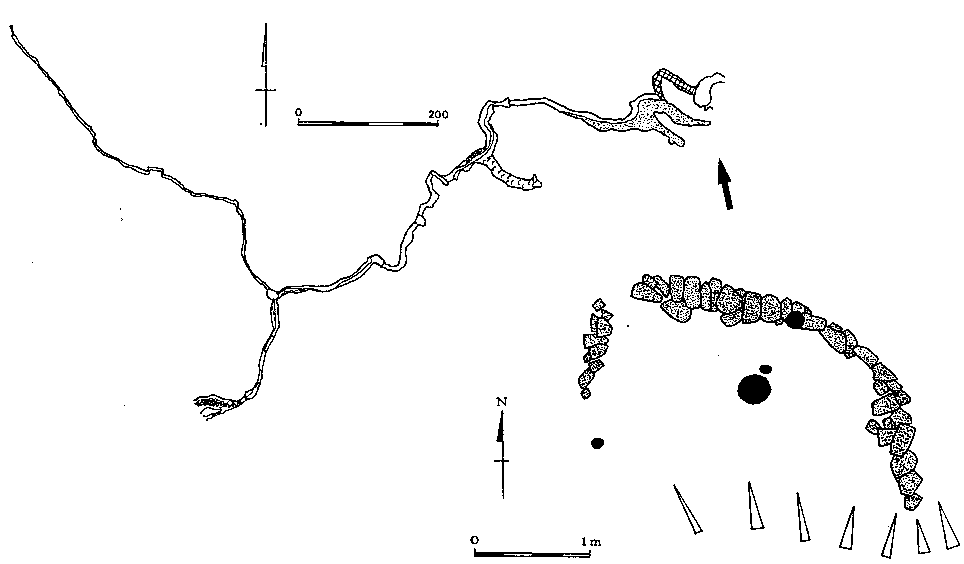
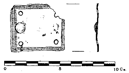
A small decorated copper plate or plaque (discussed in Fernández Ibáñez Carmelo, 2001) and small fragments of pottery were found in the first chamber, to the right of the river. A level with flints also exists under the calcite floor in the same chamber.
Samples of stalagmite were removed from the cave for dating in 1993. According to Openshaw (reference DK), only one of the stals were of use for studies of palaeosecular variation, comparing well with a UK lake sediment master curve. This gave a date of 35ka for a stal 25cm above the stream, indicating rather slow down-cutting.
To the right of the first chamber, a small passage is reached up a short climb. Sections of the roof and left hand wall are composed of a 3 - 4m(?) thick calcited bone and rubble breccia which will prove interesting if dated and the bones identified. It has been suggested that these deposits may be the remains of an ancient hyena den, in use for a long time. After 25m this passage emerges on the surface. Down to the left, a hole drops into 25m of low, dank, choked passage with anastomoses. This area needs surveying.
Some other small pieces of pottery were recovered in 2007 high on the right wall, above the bone breccia passage. These can be seen here.
A programme of water hardness data sampling (photo) was started in October 96. What were the results?
At the end of summer 2006 and into October, the river was sinking 50m upstream of the entrance. The pools on the left of the boulders just inside the cave entrance were completely dry and the water was first seen at the back of the entrance chamber, at the 1st "lake". It appears that the river has (re)opened a low level route and / or water abstraction at Cueva del Comellantes has caused less water to reach Cueva del Agua. Earlier in the summer the water had been filtering away in the river bed about 100m downstream of the Comellantes resurgence. (This point is site 2755).
Members of the Matienzo Karst Entomology Project carried out spot sampling over Easter 2019 and took photos around the entrance chamber.
The ashes of Lea Ruth Ziebold , who lived in Santander and San Antonio, and was a friend of MCP members, were scattered onto the water in the first chamber on May 9th, 2015.
On August 15th, 2021 the area around the entrance and the first chamber were used as backdrop to a TVE recording about the risks to caves from proposed windfarms. Members of the FCE and Pete Smith were interviewed, with the piece being broadcast on Cantabrian and national TV. (Interviews start at 8:33 in the Cantabrian News.) (Photos in video)
In April 2023 some searching was carried out in the main chamber for evidence of bats but stronger lights are required. (See underground photos below.)
A water trace from a sink in the Cubjia valley (near Regatón) has been started (February 2024) and is ongoing. Detectors are in Rioturto Inlet and Fuente el Escalón (Penny's Cave).
Link to entry in the Cave Diving Sump Index.
References: Puig et al, 1896; Fernández Gutiérrez et al, 1966 (survey and photo); Beardmore W and Lenartowitz S, 1972; anon., 1974b (logbook); anon., 1974a; Cox G, 1973; Fernández Gutiérrez J C, 1975; Manchester University Speleological Society, 1982 (survey); anon., 1975b (Easter and summer logbooks); Kendal Caving Club and Manchester University Speleological Society, 1975; anon., 1976 (logbook); Ullastre-Martorell J, 1975 (survey and photo); Smith P, 1985; anon., 1977b (logbook); anon., 1979 (logbook); anon., 1980a (logbook); Mills L D J, 1981 (photo); Mills L D J and Waltham A C, 1981 (survey); Corrin J S and Smith P, 1981; Smith P, 1981b (survey); anon., 1981a (logbook); anon., 1983b (logbook); Cawthorne B, 1984; anon., 1985a (Easter logbook); anon., 1985b (logbook); anon., 1986 (logbook); material in file; Cawthorne R, 1987; Garcia J L, 1987; Ortiz E, 1968; Notenboom J and Meijers I, 1985; anon., 1988 (logbook); Cawthorne B and Neill A, 1990; Cawthorne Bob et al, 1988; anon., 1989 (logbook); Neill A et al, 1989; anon., 1991 (logbook); Neill Ali, 1991; Corrin J, 1992a; anon., 1992b (logbook); Corrin J, 1992b (survey); anon., 1993b (logbook); Neill Alasdair and Jackson Keith, 1993; Corrin J, 1994a; Openshaw S et al, 1993; Muñoz E and Bermejo A, 1987; Corrin J, 1994b (survey); anon., 1995b (Whit logbook); Openshaw S, 1996 (survey); anon., 1996c (Christmas logbook); Corrin Juan, 1997a; anon., 1997d (Autumn logbook); anon., 1997b (logbook); García José León, 1997 (survey and photo); Smith Peter and Ruiz Cobo Jesús, 1999; anon., 2000c (Summer logbook); Ruiz Cobo Jesús and Smith Peter et al, 2001 (includes photo of wall with survey); Fernández Ibáñez Carmelo, 2001 (includes drawing of brooch); anon., 2002c (autumn logbook); anon., 2003 (summer logbook); anon., 2006e (autumn logbook); anon., 2007a (February logbook); anon., 2007d (summer logbook); Corrin Juan and Smith Peter, 2007; Corrin Juan, 2007a; anon., 2008e (summer logbook); Corrin Juan, 2009; Ruiz Cobo Jesús et al, 2008; León García José, 2010 (Volume 1 and Volume 2) (survey and photos); anon., 2011e (autumn logbook); anon., 2012d (summer logbook); anon., 2013b (Easter logbook); anon., 2013d (summer logbook); anon., 2014c (summer logbook); anon., 2015b (Easter logbook); anon., 2016a (January, February logbook); anon., 2016c (summer logbook); anon., 2017c (summer logbook); anon., 2019b (Easter logbook);
anon., 2022c (summer logbook); anon., 2023b (Easter logbook); anon., 2023e (Christmas logbook); anon., 2024a (January, February logbook)
Entrance pictures : From a distance : At the entrance : Entrance in winter showing the mill race wall
In severe flood : In moderate flood from above : Second, smaller entrance to the east : upstream of entrance : Easter 2013 & January 2016
summer 2016 : 360° photos (JC) - distant 1 distant 2 close up 1 close up 2 (help file) : Easter 2023
Underground picture(s): Pictures from 1975 and 1980 : Placing water hardness detector : Looking out to the entrance : entrance in moderate water conditions
entrance in moderate flood : entrance chamber, 2006 : cave life and general : pictures from ISSA : bone and rubble breccia area (2007) : pottery 2007
entrance chamber formations, 2008 : miscellaneous 2009 : entrance chamber 2011 : entrance chamber and bone, Easter 2013
main passage and ramps, summer 2013 : Signal crayfish, summer 2013 : stream passage and calcite, summer 2014 : entrance chamber January 2016
summer 2016 : stream and Snail's Pace Passage 2018 : around the entrance chamber, Easter 2019 : Searching for bats, April 2023 : entrance chamber, December 2023
Video: stream passage 2009 10Mb (Alex Ritchie) : video camera and lights trial in entrance chamber, 2011
American crayfish, summer 2013 : TVE Interviews around entrance, August 2021;
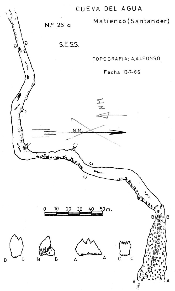
Detailed Survey :
| 1966 | known cave | low res | high res |
| 1967 | known cave | low res | high res |
| 1974 | detailed survey | high res | |
| 1975 | on area survey | low res | high res |
Line Survey :
Survex file : yes (Amended magnetic declination December 2013 to align with Eur79 grid and coordinates altered to fit ETRS89 datum, April 2014.)
Passage direction rose diagram: 30/6/2018