Updated 19th February 1999; 12th May, 12th November 2002; 4th, 26th November 2003; 18th January 2004; 30th October 2007; 7th January 2008; 5th January, 5th November 2011; 18th February, 19th September 2012; 4th December 2015; 29th April, 30th June 2018; 11th May 2019; 3rd March 2020; 19th June 2021; 14th December 2022
A route to the cave, avoiding serious 'jungle bashing', is shown on this satellite map. (This also indicates that the entrance position should be checked again - it could affect the position of passages relative to Torca Cez.)
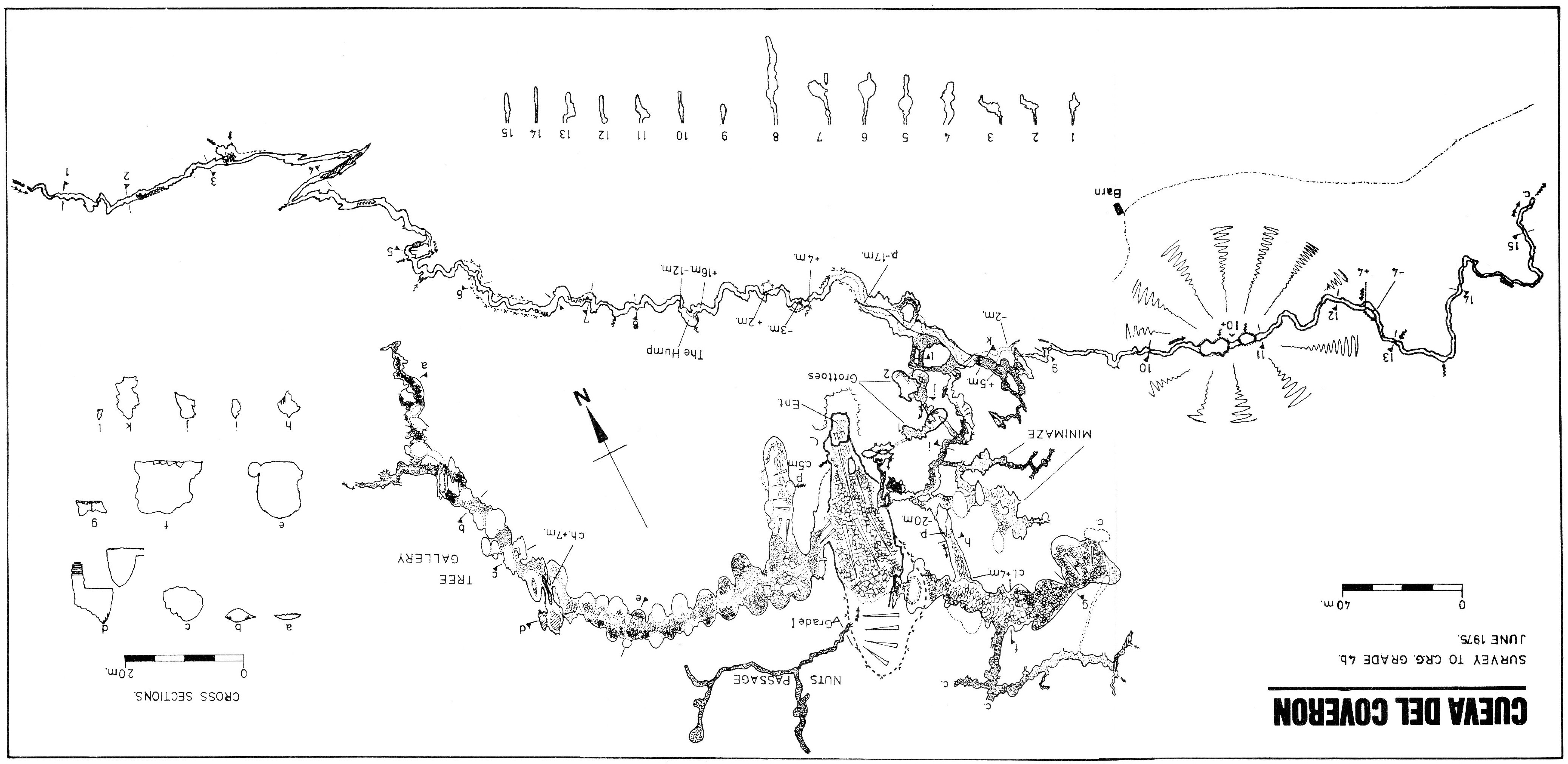
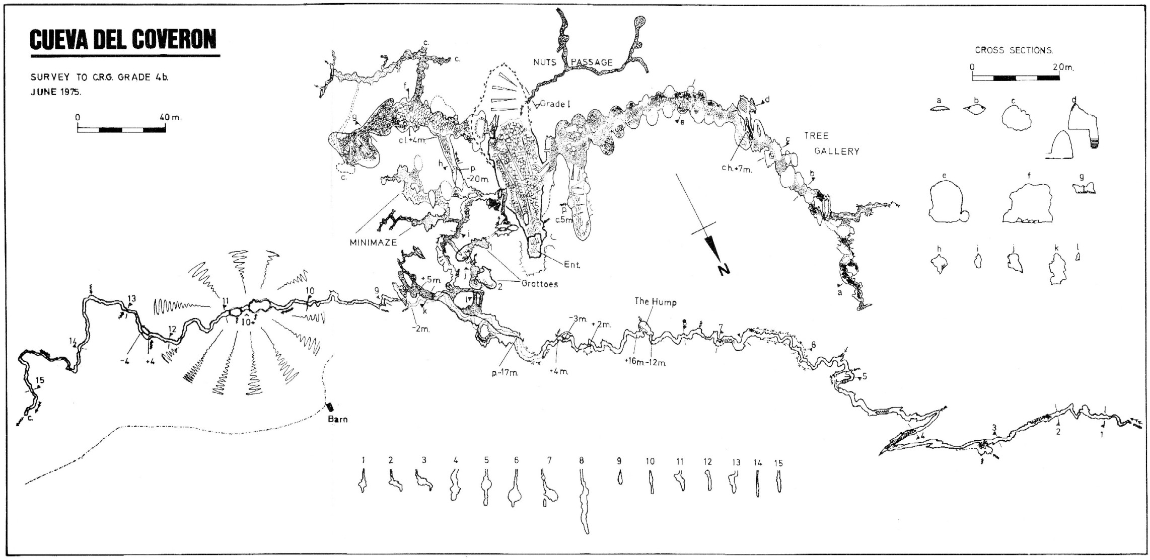
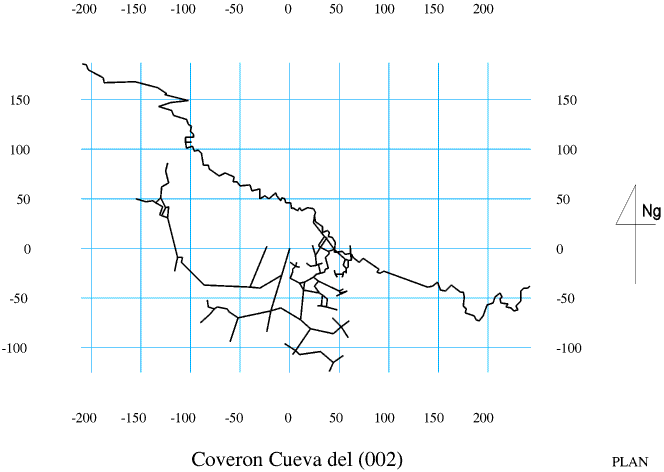
A complicated cave of great variety. The entrance "amphitheatre" has a number of small caves at the back, at least one of which provides a straight 30m drop to the main tunnel. The main entrance is a large, sloppy, leafy slope down into a sloping chamber that provides the focus to the cave. The first (and much smaller second) slope exits on the right provides access to a long series of phreatic domes, Tree Gallery. (This now has a "pathway" installed during a weekend of activities organised by the FCE, 2-4 December 2022.) The apparent end is bypassed by a squeeze at roof level possibly reached up a 7m long tree trunk. Further squeezes lead to a continuation of the domes, a division of the ways and two chokes.
Just back from the junction a rift descends to a three ways junction, one passage containing a long pool. At the far end of the entrance chamber a rift on a rock slope provides entry to Nuts Passage, a series of tubes and phreatic chambers.
The main way on is down through a squeeze on the left of the entrance chamber. Large phreatic chambers soon close down to the right and straight ahead, while to the left a 5m climb leads to the head of a 20m pitch. At the base of the pitch is the complicated Mini Maze, the route on being a tight squeeze to walking passage which runs to the top of a 17m pitch. This drops straight into the vadose section of the cave. Upstream leads to a 4m climb and drop down over a barrier. The next obstacle is a 16m high climb over greasy calcite where, near the top, pitons are useful. A 12m pitch back to the stream follows immediately. The passage then continues for 200m to a tortuous route in rotten rock until it becomes too tight.
Downstream the cave passes the odd obstacle in a mainly narrow streamway to end after a couple of hundred metres at a calcite choke. The stream is thought to resurge in the Hoyo Mortiro on the east side. Another resurgence on the west of the depression has an unknown source but could come from Torca CEZ. A water trace from the end of the Orillón system in November / December 2015 showed a strong positive at the Esquileña resurgence near Riva. Weakly positive results were seen on detectors left in the eastern resurgence in the Hoyo Mortiro. Full details of this trace can be found on the Orillónzuco site.
Several flints were found by C.A.E.A.P. in 1989 in the rock shelters around the entrance, and fragments of human skull on the entrance slope. A photo of the medieval vase is to be found in Ruiz Cobo Jesús and Smith Peter, 2003, page 41.
The cave has been extended by the AEC Lobetum, adding about 730m to the length.
The San Mateo series off Tree Gallery is shown
here.
Valero Enrique y Soriano Ángel, 2007 has the length as 3200m
and a depth of 75m. The same publication also has an
area map showing the following
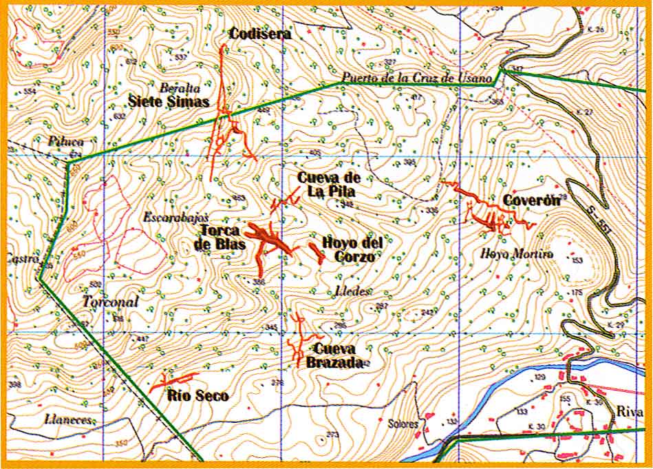
sites: Rio Seco, Cueva Brazada, Torca de Blas,
Cueva de La Pila, Cueva de
Coquisera and Cueva del Coverón.
Additional length was added during the
AEC Lobetum September 2012 visit - another 350m upstream. This extension starts before the original upstream end and bypasses the "too tight" section. There is then another 200m of streamway which ends at high avens which bring in water. These are apparently close to Torca XLs which has a cobble dig at it's base. There is possibly about 100m height difference between this dig and the floor of the avens.
With the 2009 discovery of Torca CEZ by the AEC Lobetum, lower down in the Hoya de Mortiro, a new system looks to be close to linking with Coverón. A trip by Matienzo cavers in January 2012 (by invitation) went to a couple of ends and there are various leads apparently still open, including at least one draughting dig. Both Coverón and CEZ should be resurveyed. A partial resurvey of Coverón was carried out in August 2012 (batch 0002-12-01.svx) which put the nearest point to CEZ at an altitude of 225m, possibly 20m above (inaccurately surveyed) CEZ and about 40m distant. However, see next paragraph.
Cavers from the Colectivo Piezo investigated an area in Coverón supposedly close to Torca CEZ in February 2020.
A Google Translation of their log follows:
From the entrance we descend the strong slippery ramp and to the left, at the bottom, some blocks on the ground leave a space to access a large room. From that room we reach a landslide that is consolidated by calcite precipitation. We believe that it is the closest part to Torca CEZ and we do not find any possibility of union. A little further to the SE there are some small galleries with branches that end in a meander with water. The size of this meander is reduced and, as you go, it becomes smaller. There is also no air blowing and there is no sign of connection. This area seems to have no topography, although it is not significant. At the junction of the ramp with the large room cited there is an inscription with scratches on the rock that puts 9/01/72 Martín. There is another that puts "Manolo" in the area of the collapse of the same characteristics. On the other hand, the installation of the fixed rope to access the tree gallery is in terrible condition.
New grid references for CEZ and Coverón seem to show the two caves 40m vertically apart, with CEZ below.
Colectivo Piezo have also manually put drawn surveys of CEZ and Coverón together (Spring 2021) and the result can be inspected here.
Over Easter 2018, the Matienzo Karst Entomology Project (led by Tom Thompson) followed up previous work by collecting bugs, spot sampling and setting pitfall traps in a number of sites under a Cantabria-wide permit. Traps were retrieved and spot sampling was carried out over Easter 2019. Photos were also taken.
References: Fernández Gutiérrez et al, 1966; anon., 1975b (Easter and summer logbooks); Kendal Caving Club and Manchester University Speleological Society, 1975 (survey and photo); anon., 1975a; Manchester University Speleological Society, 1982 (survey); Mills L D J, 1981; Mills L D J and Waltham A C, 1981 (survey); Corrin J S and Smith P, 1981; material in file; Garcia J L, 1987; anon., 1988 (logbook); anon., 1993a (survey); Corrin J, 1994b (survey); García José León, 1997 (survey); Corrin Juan, 1997c; anon., 2000e; Ruiz Cobo Jesús and Smith Peter, 2003; Valero Enrique y Soriano Ángel, 2007 (survey); León García José, 2010 (Volume 1 and Volume 2) (survey and photos); anon., 2012a (January, February logbook); anon., 2012d (summer logbook); Papard Philip, Corrin Juan and Smith Peter, 2014; anon., 2018b (Easter logbook); anon., 2019b (Easter logbook); anon., 2020a (January, February logbook); anon., 2021b (Spring logbook); Simonnot G, 2022
Entrance pictures : 2002 & 2008 : Spanish team (2009) on Facebook : Easter 2018 : Easter 2019
Underground picture(s): Entrance slope and Tree Gallery 2008 : Spanish team (2009) on Facebook : Easter 2018 : Easter 2019
Detailed Survey : 1975 high res 1975 low res Tree Gallery extension
Tree Gallery extension - San Mateo (anon., 1993a; AEC Lobetum) high res low res
combined 0002-3603 (Piezo)
Line Survey: coordinates taken from paper survey (z-coords will be way out)
On area survey : line survey with partial Torca CEZ line survey
Survex file : partial Coverón survey with partial (inaccurate) CEZ survey (2012 - Amended magnetic declination December 2013 to align with Eur79 grid) :
Off drawn survey with approximate z - Amended magnetic declination December 2013 to align with Eur79 grid and and coordinates altered to fit ETRS89 datum, April 2014.
With CEZ, Orillón and Mortiro-Esquilón (amended Feb 2020: USE THIS ONE; new entrance grid references & altitudes)
0002 solo - note batch 12-01 makes the orange level above redundant (Feb 2020)
Passage direction rose diagram: generated 30/6/2018